Topsy Turvy.
That's how my life has been lately. Twisted around by work and weather and eventualities, I barely feel like myself. On the one hand, it's kind-of nice to get a break from the routine, but on the other hand, I really like some parts of the routine and I don't really want a break from them. For example, I've been stuck in the house and I haven't seen the sun or set foot on dirt in weeks.
Weeks!
Last Saturday I tried to end that run though, with a little trip to Roswell. It's not really "the woods" but there are trails there, and thus I must hike.
I parked at the Old Mill Park. The kids and I had stopped by a few months back on the way back from riding the Riverside Trail but we just looked around a little. You drive down to the lot from Hwy 9 and it seems like a good way down, but then there's an even more precipitous drop from the lot down to the river.
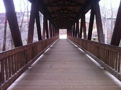
There are some ruins of an old cotton mill down there and a covered bridge down there that takes you across the river.
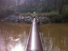
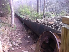
Down by the river itself there's a network of pipes running up and down and back and forth.
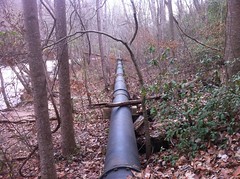
I'm really curious about the pipes, actually. Where do they go? What are they for, exactly? They don't look big enough to be drainage or sewer lines. I guess they could be part of the water supply, but they're way down in the creek, lower than I'd expect supply lines to be.
There were a dozen or more people walking around down by the river, not all together, but in a couple of little groups. It looked like a popular place. Aside from the pipes, there were other interesting sights down there too.
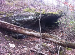
There was this crazy cave-rock.
And it rained torrentially for days last week so the creek was raging over the little shoal under the bridge.
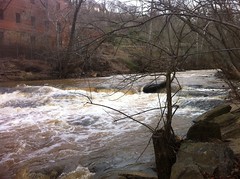
The creek, by the way, is Big Creek - the same Big Creek that the girls and I ride along so often, just further downstream. On the west side, where I parked, the land is owned by the city. Across the creek, the land is part of the Chattahoochee NRA, in the Vickery Creek Unit. In antiquity, Big Creek was known as Vickery Creek, named after a Cherokee woman who owned a farm somewhere upstream.
I didn't find a trail map online (though I must admit that I didn't try all that hard) so I was really just kind of winging it. I had a topo map, and it looked like basically there was just one big hill in the area, hemmed in by Big Creek, the Chattahoochee and some neighborhoods.
The trails along the river looked kind of unofficial, so I headed back to the bridge and up some stairs. I figured if there were stairs, then there were probably real trails at the top. And yea, there were.
Most of it was doubletrackish.
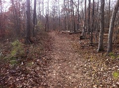
But the park wasn't entirely without singletrack.
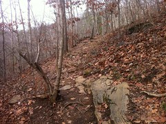
Along the river there appeared to be dozens of scramble paths too where people climbed down over the rocks to get to the water. Those are very common, up and down the entire Chattahoochee. Further upstream they have become cavernous but with all the rock in the area down there, they weren't so bad.
I headed up to the northwest corner of the park and followed a trail back along the river. It was wide and clear, and then ended abruptly at a bridge of sorts.
Hmm. It appeared to be the right way to go.
When I was a kid in Texas, we used to cross pipes like that all the time. There was one in particular that I had to cross to get to the school behind my neighborhood if I wanted to skate there, otherwise I had to go like a mile around the other way. The pipes in Texas were generally suspended 10 or 15 feet above a dry canal but still, it was similar enough to trigger a flood of good memories.
Across the creek the trail led along the creek but there was a dense tangle of Autumn Olive blocking the view. Here and there little side trails led down to the water, but not for any immediately obvious reason. The water looked deep and slow there though and after a while I started to wonder if you could swim there.
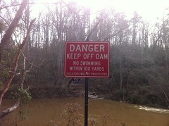
The further south I went, the more I could hear the roar of the dam, and as I approached it, I got the answer to my question.
Apparently so. I know what I'm doing this summer.
The river raged over the dam with furious effort and a deafening howl. If the dam had cracked and burst and gone tumbling downstream, it wouldn't have surprised me in the least.
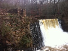
The main torrent was impressive, but I was more interested in the raceway outlet.
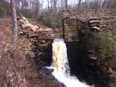
Water would pour through that outlet, run along a long flume...
and drive a wheel at the end which ran all this crazy machinery.
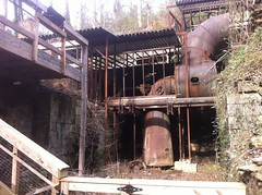
Apparently the flume was first made of wood but eventually they replaced it with that metal pipe.
There are interpretive signs all over with old photos but man I really want to see one of those old mills in action. There's got to be one somewhere in North Georgia still running. Standing there, looking at all of it, it was amazing. The things that people put together back then... There was no gasoline, no electricity, barely even steam. A water-driven mill was the height of technology, built by hand out of rough timber, brick, mortar and cast-iron. The scale was amazing too. It was enormous. There was a dam and multiple buildings packed full of pipes and wheels... It consumed acres, and that's just the part of the mill that generated the power, never mind the rest of it. Today you could get the same work out of a little engine sitting on a concrete pad with a natural gas line hooked up to it. I'm sure in another hundred years the enormity of even that will seem preposterous though.
As impressive as it might have been, it's all falling apart now.

I don't know though, that might make it even more interesting.
I crossed the covered bridge again and explored along the east side of the river some more.
There was a rope swing...
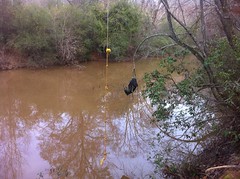
...and an old shirt tangled up in the tree revealed a recent high-water mark.
A rough trail followed the creek for a long time and eventually petered out in some thorns. Leave it to me to find thorns. I will find them. That is one thing you can count on.
I ended up backtracking a lot on that side, looping back to pick up trails I'd seen earlier.
The whole system is situated at a big bend in the river and along the north side of the property there was another pipe that you could cross to get to the parking lot for the aptly named Oxbo Trail.
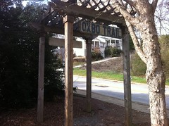
The Oxbo Trail is a wide gravel trail running along the north bank of Big Creek. The Historic Roswell Trail tees into it near there too. I wonder if either or both are open to bikes? If so, they looked like good places to ride with the girls.
I headed back across the pipe, backtracked some more and found a nice piece of singletrack that paralleled the river, higher up the bank. Later I would discover that it was not part of the official system trails. Until you just know the system, it's difficult to tell where you're supposed to go out there.
Eventually the trail went under another pedestrian bridge, upstream of which was another dam, the purpose of which wasn't entirely clear.
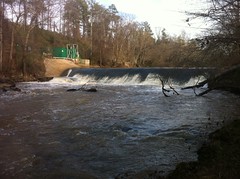
The lower dam was there to run the mill, but this one was modern and didn't appear to have any machinery attached to it. At some point, I will have to inquire further into the matter.
Just south of the bridge, somebody appeared to have abandoned their guinea pig.
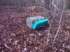
Maybe it bit them. Beware the feral guinea pig of Vickery Creek. It can't be tamed. It kills for sport.
Witness it's fury:
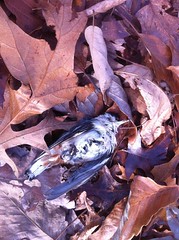
I'd say 9 times out of 10 when I see a dead bird, all I really see is a patch of feathers. Whatever killed it apparently de-feathered and ate it right there. But now and then I see one just lying there, dead and uneaten, except partially, by ants. Did it die of natural causes? Did it taste bad? Was the killer scared off? How?!
The entire trail system runs around and over a single hill and eventually I made my way up to the top of it. The topo map showed a square clearing up there, but there was no discernible clearing any more.
There was, however, this interesting little pen.
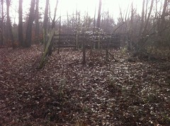
Or at least the ruins of one. I'm not insufficiently well-versed on farm structures to identify what kind of pen it was. Corrals are typically round. Poultry is generally completely free-range or kept completely indoors. On the opposite side, there was a small chute that didn't look big enough for cows or horses. Pigs? Maybe?
As interesting as all these little points of were, my body was falling apart on me. My right leg, in particular, felt like it had been transplanted from somebody who had never walked a mile in their life. The front of my hip was sore. I have actually wondered if I have a bone spur there that the tendon just grinds across. That's what it feels like. If I stretch, it's manageable but sometimes it really hurts. My knee felt like I'd landed wrong on a 12 stair ollie. My calf was sore. MY calf was sore. How does that happen?
It was Christmas Eve too and I didn't want to be out in the woods by myself ALL day. I'd only explored about half of the system, but it was time to pack it in.
There's still a bunch more to see out there, including the ruins of another entire mill. Maybe I can coerce the girls into joining me next time.


No comments:
Post a Comment