It's funny, this was only a week ago, but I remember it less clearly than the last 3.
When Billy and I most recently explored the upper Blood Mountain Wilderness, I was surprised when we didn't run into an old road leading south along upper Dick's Creek. The USGS map showed one. Long ago, I'd seen what I thought was the bottom of it. We did see an old overgrown thing that might have been it, but it didn't look like a good candidate. I figured I'd attack it from the bottom, and see what was what.
I parked at the switchback and got to it.
It appeared that FS34 itself used to continue directly up along Dick's Creek at some point. There was a weird fill there too. Rather than sidehilling into a little draw, whoever built the road filled the heck out of it. It wasn't rock-armored like the rest of the old railbed fills I'd seen in the area, but it did remind me of some of the fills I'd seen up on Pigeon Mountain for the light gauge ore rail they'd built up there way back. The only reason I puzzled about it at all is because I have this book that alleges that the Morse Brothers ran a rail up along Dick's Creek. One spur followed Blood Mountain Creek. Another followed Dick's Creek proper, presumably along the current corridor of FS34. Both of those had secondary spurs. I think I found the one leading along Blood Mountain Creek last time. It's not clear from the map in the book exactly how far up Dick's Creek proper the main line ran. That fill seemed to indicate that it went farther up than the switchback.
It was actually tricky getting on the old road/rail at all. There was a tangle of trails up there. One was the old road/rail, another led down to an old campsite. Another led along the little ridge in the area. There were several connecting it with the old road/rail. It was a mess. To make matters worse, there was apparently a trestle/bridge there at some point. It was long gone there was dense overgrowth to either side of where it must have been. Nobody seemed to go that way any more, and I wasn't looking forward to pushing through miles of completely abandoned railbed.
Fortunately I noticed where people do go now, and quickly found the trail I was looking for.
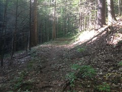
Looked like an old rail that had been converted to a road. The grade was really consistent, but it was wider than necessary for a railbed, and here and there it had rolling dips cut into it.
The hike up was pleasant. No brush to speak of. It was a popular route, as unpopular routes go.
There was one very odd feature though. Paralleling the length of the old road, there was an older-looking, narrower bench cut, directly above it. This little cut went into and out of every little draw, where fills had been built for road.
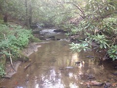
It reminded me of a similar thing that's visible along Hwy 52 coming down off of Fort Mtn toward Chattsworth. My best guess was that it was the original trail that had been built, or maybe just worn in, and for some reason, rather than build the rail/road directly on top of it, they cut in to the left of it. I'm not sure why they would have. There's a similar thing on the Dockery Lake trail, but it's only about 100 feet long. This one was like a half mile long or more.There were several little feeder streams too.
And when I followed the trail to its furthest extent, I ran into this waterfall-ish thing.
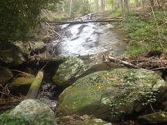
That would have been the end of the line for the rail. Unless there were some amazing set of trestle-switchbacks, there was no getting over that falls. There could be a skid up above it. There might have been a slide. I'll have to go look for that some day. At the time, I didn't feel like scrambling up over the falls.
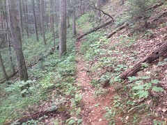
I'd seen a spur to the left earlier. Two, actually, and upper spur looked like the way people go these days.
That trail was a little weird too. The lower spur looked like it had been constructed with equipment. The upper spur looked like it had just been worn in over the years.
I couldn't imagine why at first, but I eventually saw that there was a big gap in the lower spur. It had either been washed out, or spanned by a trestle/bridge that had been washed out. The upper spur eventually joined the lower above the break.
Way up, someone had dumped a bunch of old cans off to the side.
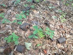
That's just what I could get a photo of. There were a lot more. Trash or artifact?
You decide.
I guess at some point, fairly recently, it was possible to get a vehicle up there. Though, it seemed more likely that whoever had driven out, had done so from the other side. I was in the general vicinity of Miller Gap. There are properties to the north even today. Maybe it was somebody's granddad.
The trail eventually got cleaner and cleaner, and I even started to hear voices. I wasn't going crazy. The AT was above me, and the old road had been converted to a camping spur. There were three older gentlemen settling in for the evening, and they were a little surprised to see me coming from that direction. There was a small maze of trails up there too, and it wasn't immediately obvious which was the AT. I actually had to ask a second group where it was.
Oh! Also, I got to talking with the first three guys and found out that they were super confused by the bear lines, so I showed them how to use them.
I took the AT north, expecting to have to hike to Jarrard Gap before dropping back in. I found another little spur leading down a few hundred yards up though, and it just put me back on the same trail I'd taken up.
Good enough.
The hike back was uneventful. No people, no wildlife, no trouble of any kind.
I still don't know why the map says that the trail along Dick's Creek tees into the trail coming down from Burnett Field Mountain, but those old quads have errors like that sometimes. This quad alone has several such errors. I guess I'll just have to do more some exploring to figure it out.
"Darn."


No comments:
Post a Comment