Catching up. Two weeks ago...
Actually, lets back up a bit from that even. Paulding Forest is basically right next door. I'd ridden the Silver Comet across it several times, and I'd ridden the PACO Mixed Loop with my brother, but otherwise I'd never given it that much thought. A few months ago this occurred to me, and I couldn't really justify why not. I pulled up some maps, studied them, and realized how much land is actually out there. It seemed ripe for exploration, but I knew that Dawson Forest had some odd rules. Specifically, in Dawson Forest, bikes and horses are only allowed on trails, and not on gravel roads. Vehicles are, but not bikes or horses. I knew that the Georgia Forestry Commission managed both lands, so the same rules might apply to both Forests. I didn't want to assume, so I emailed Tony Pope at the GFC. He was pretty sure that bikes were allowed on ungated roads (because they were county-maintained), but not on gated roads, but he recommended that I check with the DNR and let him know if they thought otherwise. So, I did that and the DNR rep said she believed bikes were allowed on any road, gated or not. So, I emailed Tony again, and he sorted it out with the DNR. I felt bad about creating all of that work for him, but he seemed grateful that I had uncovered the misunderstanding. Unfortunately for me, the correct understanding was Tony's. No bikes on gated roads.
Dangit!
But! There were still plenty of ungated roads. They crisscrossed the map left and right, and I wasted no time exploring and mapping them in my truck. After a couple of days of that, I had a loop worked out. Really, it wasn't much more than the PACO Mixed Loop with some extensions, but the extensions looked really promising.
That was months ago though. As quickly as I had put the route together, I sure took my time getting out there on the bike. Other things to do. Other places to be.
Finally, a few weeks back, I checked out the route.
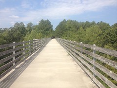
I parked at the Rambo Trailhead on the Silver Comet, and headed west. It had been a while since I'd been out that way, and I'd forgotten about the high trestle out there.
It took longer than I remembered to get to the turn-off. I worried that I didn't have an accurate idea of the scale of the map, and thus the length of the route. The start was near Dallas, but the route would eventually take me way up by Cartersville. I'd done a road-ride like that once, and it was long. Almost 100 miles. This route was shorter than that, but I wasn't sure how much shorter. I'd done that other ride on the road bike too. This time I was on the mountain bike. Yeah, I wondered if I hadn't bitten off more than I could chew.
I did find the turn off though, at McPherson Church Road. That led to Johnny Monk Road.
From there, I rode north to High Shoals, Raccoon Creek, and Thomas Road.
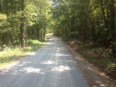
Driving in the truck, I'd declared some of those roads to be gravel, but on the bike I realized that they had once been paved with asphalt, and had just deteriorated into a terribly rough state over the years. They were awash with top-off, but there was still a layer of asphalt deep underneath.
I'd gotten a reasonably early start and it had been reasonably cool, for a Georgia summer at least. High 80's. As the morning wore on though, it was getting warmer and warmer, and there were long stretches along Braswell Mountain Road and Hwy 61 with a lot of sun exposure. I was burning through my water ahead of schedule. I had identified a number of opportunities for resupply along the route though, and I was sure I'd hit one of them before I ran out. So, I didn't worry, and just pressed on.
On Lucas Road...
...I was passed by a couple in a BMW. Further on I found them stopped on the side of the road, consulting their GPS. It seemed they'd been told to go that way, but weren't too happy about the dirt and gravel. I passed them back and never saw them again.
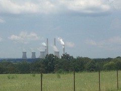
Lucas road crosses back and forth across a right-of-way, buzzing with high-tension wires leading directly to Plant Bowen. I could see it in the distance, and it grew each time I crossed the right-of-way again, but it seemed tiny and it just underscored how long the ride might actually be.
Further down the road, I came around a curve and I saw a woman standing on the opposite side, dressed in street clothes, with a phone in her hand, seemingly taking a selfie. I was confused at first. I saw no vehicle in her vicinity. There wasn't anything interesting in the background.
????
Well, my assumption about the selfie was actually wrong. These days, I apparently assume selfie when I see someone holding up a phone. She was actually filming something else. There was a vehicle, just up the road. A Jeep, in fact, driven by her girlfriends, excitedly, at high speed, toward a mud puddle on her side of the road. The puddle was deep, but it wasn't very wide, and only the passenger-side wheels actually ended up in the puddle. This, of course, yanked the jeep toward the edge of the road, directly at the lady with the phone. She managed to step out of the way, but it was pretty close.
I'm pretty sure the video was pretty amazing. I can only imagine how the expressions of the lady driving must have changed during the course of the stunt.
Woohoo! I shouted, and carried on.
Before long I was back on pavement.
And eventually on Hwy 113.
Plant Bowen loomed in the distance, but that was as close as I got to it.
My water was running pretty low, so I stopped at the Dollar General along the highway there, grabbed a couple of 20oz Gatorades, and got back on the route.
The last time I was up that way, I'd ridden straight up Hwy 113, which wasn't that much fun. Since then I'd explored the side roads to the east, and figured out a way to connect them together and avoid the highway as much as possible.
Unfortunately there's no dirt on those roads, but there was a county-line sprint:
(which, of course, I took)
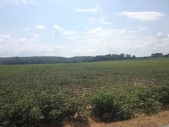
Field after field of cotton:
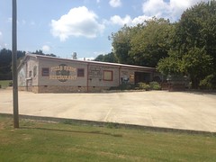
A Pizza Farm:
...and plenty of shade.
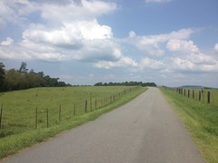
There was a bit of a kick leading into the community of Braswell, but aside from that, the roads rolled gently.
I'd burned through my first bottle already, and started into the second one. I hoped that the convenience store was open, but I was out of luck.
Yeah, it was a quiet afternoon in those parts. A police car sat outside of the local city-hall/police-station/catch-all-government-building. A lady was milling around the lot outside of her apartment building across the street. Nobody drove by.
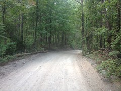
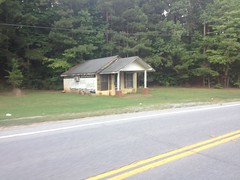
I took Skyline Drive past whatever the abandoned building down it is. The road quickly became dirt and gravel, crossed a neighborhood street and continued on to the railroad tracks that crossed the forest.
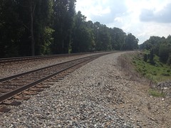
The same road picked up on the other side. They had clearly been connected in the past.
From there I took Brushy Mountain Road and Yorkville Pass into Yorkville proper. That's where I did most of my climbing, but it wasn't really all that much. The toughest part was the burning sun, and my dwindling supply of Gatorade.
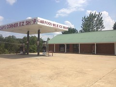
The Yorkville Market was nearby though.
And I'd barely run out when I arrived there.
My ride was mostly done, but I still had a few miles left on Goldmine Road and a mile or two back to the start along the Silver Comet. Two more Gatorades later, I was back on the bike.
I passed the old Jefferson Island store...
...and I crossed Hwy 278. I was surprised how good I still felt. I hadn't felt "strong" at any point, but I hadn't bonked, or cramped, or developed any particular pains. There had been a few times when my 30 tooth 1x11 was a little undergeared, but only a few, and only on the road.
Willow Springs led to McPherson Church, and that led back to the Comet. I pondered the idea of hitting the side trail, but I'd had a decently long day, and I didn't want to push my luck.
I still don't know how many miles it was, but it took about 5 and a half hours to ride. Except for the heat, it wasn't too tough. The mountain bike might have been unnecessary too. I suspect that I could have ridden it all on the road bike. Skyline road was the only sketchy part.
There are plenty more dirt roads to the south. I think that I can put together an even longer route. I might wait until it's a little cooler outside to ride it though.


No comments:
Post a Comment