This past Saturday I had the option of riding in Ellijay with Baldwin, or doing trail work at the new Yonah Preserve with Clark, but I ended up doing neither! Late Thursday afternoon, the power went off at one of my client's sites, and I spent all day Friday getting things straightened out again. Then, Friday evening, a UPS failed and I spent Saturday morning straightening that out. Dangit! No ride. No trail work. I took the opportunity to catch up on sleep though and woke Sunday morning refreshed and ready to explore my world.
Saturday morning was Father's Day, but my family is out of town, so we're going to celebrate it when they get back. I had the whole day to myself.
All that exploring I've been doing at Pinelog has gotten me interested in the mineral history of Bartow County. Seems they did a great deal of mining around those parts, way back, and still do. Iron, Manganese, Limestone, and Ochre seem to be, or have been, the principal industries, and since they were for so long, relics still stand from the bygone times. I've found some of them, but many more remain.
Seemed like a good day to go searching for some of them.
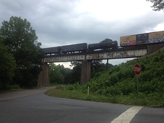
First up, the old Etowah Train Bridge. You can see it from Hwy 41. I'd see old photos of it, back when it was in use, and it was on the way to other stuff, so I figured I'd check it out.
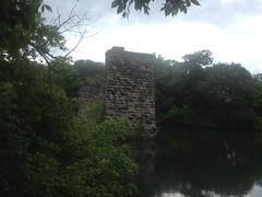
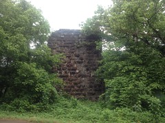
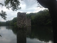
The bridge was built in the 1840's, burned and was rebuilt a couple of times during the Civil War, and was finally decomissioned in 1954 and replaced with the new bridge.
All that remains of the old bridge are the piers and some small amount of who-knows-what on top of them. I guess the iron could be scrapped, but there was no profit in tearing down the piers. As such, I imagine they'll be around for a pretty long time.
Next up, the Akin Lime Kiln. I'd seen photos of it, and it looked pretty cool. Also, the description of its location was pretty good: about halfway between Cassville and Kingston, on Limekiln Branch, near the old Cave Station.
Cassville and Kingston are easy to find. Modern topo maps show Limekiln Branch. Historical topo maps show "Cave" as a stop on the railroad, right at the branch. It ought to be right there.
Yep. The side of the road was slightly worn, and there was a bit of a hole in the woods there, leading to a nice old roadbed.
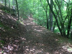
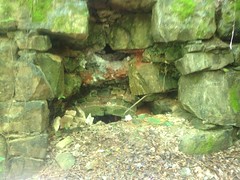
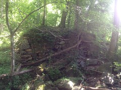
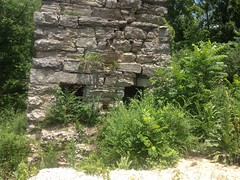
And just up the road, the kiln emerged from the backslope.
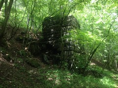
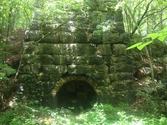

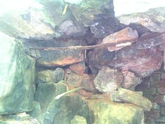
My understanding of lime kilns and their operation is somewhat limited. But, as I understand it, there was basically a refractory brick chimney in the middle, surrounded by a stone structure for support, with dirt packed between them for insulation. Brick-lined arches provided access to the bottom of the chimney. The chimney was stacked loosely with alternating layers of wood and lump limestone. A fire would be built at the bottom and would burn its way up through the stack. Air would be drawn in through the arches. Lime would be converted to quicklime. Eventually the fire would go out, the furnace would cool, and the good stuff could be raked out through the arches.
Arches (or what's left of them):
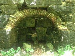
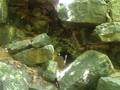
Chimney:

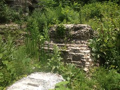
There were a lot of bricks in the exterior of the kiln. I wonder if they patched holes, or if they were just always there.
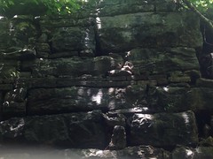
There were also a bunch of metal straps sticking out here and there. Their purpose wasn't obvious at the time.
The kiln was operated around 1912, I think. I imagine they must have used the quicklime to make cement and mortar, and maybe in agriculture. I'm not sure what else.
The old road kept going north, and there was plenty limestone lying about, as might be expected.
The map shows the creek continuing way up the draw, but in real life, it disappears into a boulder field. It may flow at other times of the year, but Roger's Spring, slightly east of the field...
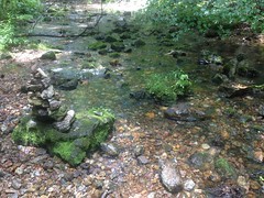
...appears to supply all of the water in the summer months. I wonder if the mountain is mostly limestone, shot full of underground passages, and the creek flows as much below ground as above it, just emerging conspicuously at the spring.
Uphill of the kiln there were 2 distinct quarries.
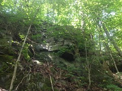
It seemed like there was one along the creek too, but I could be wrong. It might have been a natural formation.
On the way out, I noticed abutments for an old bridge.
I guess the main road used to cross there instead of in its current location.
Not sure how I missed them on the way in.
All right!
Next up, the Howared Cement Kilns.
Again, the description of their location made them easy to find. They were located in Cement, Georgia, north of Kingston. The town is gone, but both old and modern topo maps both still show "Cement" as a place, and if you're looking, the kiln is hard to miss.

Unfortunately, the ruins mostly lie behind a gate, with big chunks of rock placed to prevent people from driving around it. There were no "keep out" or "no trespassing" signs, but still...
Cement kilns of that era operate much like lime kilns, just at a higher temperature. At the higher temperature, you get alite rather than quicklime, which is the main component of portland cement.
There are allegedly ruins of a cylindrical kiln to the left (north) of the main kiln, but I couldn't go over there to check it out without crossing the gate, and it was so overgrown that I couldn't make out anything distinctly.
To the right (south) of the kiln, on this side of the gate, there were footings of some kind.
One of them appeared to have a cylindrical, brick-lined hearth.
There were allegedly up to 6 kilns running on the property, at some point. Maybe they lay in a line from north to south.
Old photos show various processing buildings to the south and in front of the kilns, but only the double and cylindrical kilns are visible in the photos. Any other kilns are obscured by the buildings.
The whole are is super, super overgrown. I couldn't make out much else with all of the brush.
One thing did strike me though... It's not clear how everything was powered. The nearest creek is across the road, and across the tracks. There's a small creek to the north, and the map shows a pond on it. Maybe water was piped over from there? Why wouldn't the kilns have just been built closer to it though? Maybe everything was powered by steam engine? I can't find any info about any of that.
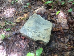
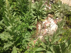
Oh, also... I found something in the brush that I recognized, but don't remember what it is. What are these?
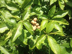
At first I thought paw-paw, but they're too small for that.
???
Ok, that was it for the Howard Cement Kilns.
Next, I made a half-attempt at locating the Pumpkinvine Kiln. All I know is that it's located on Pumpkinvine Creek. That was easy enough to find, but it's very long, only accessible in a few spots, and the kiln could be anywhere. I did see one trail that looked promising, but it was apparently just a fishing trail.
Blah! Onward...
No trip to Bartow County would be complete without a trip to Pinelog, and my day ended with one of those. The details would read much like any other trip to the area, so I'll just get to the discoveries.
Pit mine on the ridge east of Alexander Hollow:
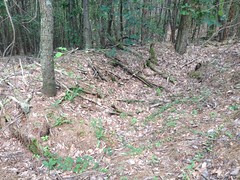
Looks like nothing. Again, a hole in the ground is difficult to photograph.
Flooded mine shaft just uphill from the pit mine, on the other side of the old road:
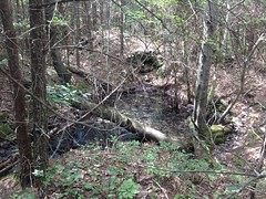
I say shaft because the pit itself was much smaller than the waste piles surrounding it. It must, at least at one point, have been an actual shaft.
Some of the rock in the waste piles had been organized into low walls.
A long trench had been cut from the shaft to the road too.
Mylar ballon:
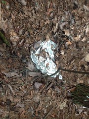
I realized recently that I'd stopped mentioning seeing them. Rest assured, I have encountered at least one per hike or ride.
Eastern Hognose!
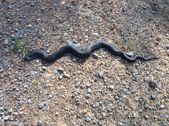
At first I thought it was just a run-of-the-mill black rat snake, and I wasn't even going to take a photo, but it looked a little heavy bodied, so I stopped for a second and it had already started to flatten out.
I've read that they play dead if threatened, so I hoped that it would do that, but instead it got super mad, hissed, and acted like it was going to strike.
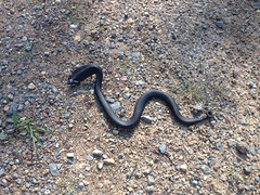
Ok, sorry buddy, I'll leave you alone...
Later I read that they try to scare you first, by flattening out, hissing, preparing to strike, and striking, but not actually biting during the strike, just head-butting you. Then, if that fails, they flip over and play dead, sometimes sticking their tongue out, and even emitting some stank from a stank gland in their cloaca. Nice! The hissing and strike-preparation was enough for me. Good job snake! Faked me out.
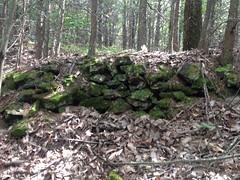
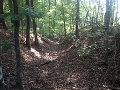
Conner Ore Bank:

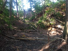
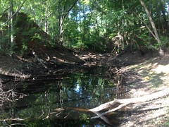
One of the iron mines along the old Iron Belt Railroad.
It consists of 3 large pits that stay filled with water most of the year. One of them was mostly dry yesterday.
I presume that this is the Conner Ore Bank, as it sort-of matches the description of the location given here. I guess it was worked a bit more since that was written. I can't find any other reference to any other ore bank that it might be.
Someone hammered a light-gauge rail into the bottom of one of the pits.
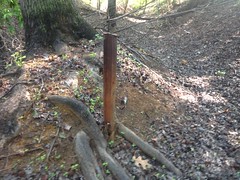
It looks like it's almost rusted through at the base.
There was also a long trench cut south of the pits, leading to a nearby dry stream bed.
It wasn't just an old roadbed, for sure. Its location and design suggested drainage. Maybe for an ore washer? Maybe water had to be pumped out of the pits regularly?
Historical topo maps show a pond across the road to the east, but I haven't explored that area yet. Maybe it will shed some light.
And that was it for Pinelog.
I wrapped up the day with some delicious Wendy's and headed home.
Ok, so that was my Father's Day. I explored my world and actually found stuff! I win!
There are still a dozen more things to be found though: Pumpkinvine Kiln, Donaldson Furnace, Cooper Furnace (actually I know where that is, you can see it from space), Etowah Furnace (which I think is submerged under Lake Allatoona), Etowah Manganese Mill, various mine cuts that I can kind-of see from the road, some old bridges, cemeteries... Not to mention everything else in the rest of north Georgia.
Enough to keep me occupied for a long time.


No comments:
Post a Comment