Where in the world is Tickanetley? You know, up north of Amicalola, south of Noontootla, east of Nimblewill... Tickanetley.
It's been a while, so I can't remember now what possessed me to ride that particular route. I remember that I wanted to get in 3 decent climbs, and that it had rained recently, so I didn't want the route to be singletrack-heavy. Also, I couldn't remember the last time I'd been up there. Seems like maybe it was with Johnny and Norma and Russel on Superbowl Sunday the year the Saints won, which was in 2010, I think.
Well, whatever my reasons were, I drove up to Bucktown and parked at the gate of the long-defunct Anderson Creek ORV trail system, put the bike together, got dressed, and started climbing.
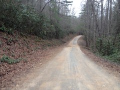
The road there is FS28-3, AKA Old Bucktown Road. Last year the Fools Gold riders climbed it over Nimblewill Gap, spun a loop around Bull and Jake, and then climbed back over. I planned on doing an abbreviated version of that.
FS28-3 once had a reputation for being completely trashed - rocky, rutted, and dangerous. Ten years ago it tested my 4WD skills to the limit. One ride up there Billy and I triple flatted and I had to ride out to the Hightway on a flat tire while he went and got the car to pick me up. The last time I rode there it had snowed, the ruts were obscured, and I kept breaking through the ice and dropping down into them well past my hubs.
Not so any more.
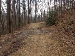
It's still pretty rocky.
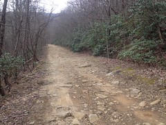
But I doubt I'd have any trouble driving it.
There was a guy behind me that was having a little trouble though, or at least was taking it slow.
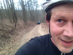
He gained on me little-by-little, but I managed to outpace him all the way up to Nimblewill Gap, and then I was gone and never saw him again.
Oh yeah... It was in the 60's when I started, I was dressed for the 60's, but it a lot colder as I climbed. I could see my breath at the gap. Tearing down into Nimblewill Valley was the ultimate conundrum. It would get warmer as I got lower, and the quicker I got lower, the warmer it would be. But the actual process of getting lower was freezing, and the faster I went, the more freezing it was. I could imagine the differential equations that would be necessary to model that and found myself thinking about that I as I rode, and then laughing at myself for being such a nerd.
Nerd!
On the way down, I passed a couple with fly-rods, coming up from the creek. I guess it's finally just barely warm enough to fish.
My loop around Bull Mountain would be well short of anything worthy of the Fools Gold. I didn't even plan on riding much of Bull Mountain proper.
On the 83 Bypass, it looked like Debbie and Co. had done some mitigation of the really bad spot.
If that holds up, it would be worth considering armoring it all the way to the switchbacks. That first chunk is a mess, but the rest of the trail is pretty much fine.
I took trails to the Bull Mountain Lot, climbed up to the road, and took the closed bit of 83 around to Booger Holler.
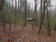
Some dudes were milling around that cabin for some reason. I've been riding Bull Mountain for 18 years, at all times of the year, and I'd never seen anyone at the cabin, or any sign that it was still even partially inhabited until this past ride.
From there, I climbed up the Whoop-de-do's, back to Bull Mountain proper.
The rocky rolling dips were performing superbly.
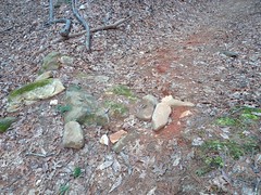
We laid those rocks on the left in late 2017 and they look like they've always been there. The ones on the right are a bit loose, but they're not important. Those big foundation stones anchor the dip, and they appear to have gotten pretty well cemented-in.
I rode down the lower piece of Bull Mountain, took FS83 and the bypass back to 28-1, hung a right on Nimblewill Creek Road, and started climbing back over the gap.
Wooo!
My little engine could, but just barely.
I kept trying to spot the gap in the ridge, but however close I got, it always seemed interminably far away.
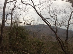
I meant for that to be a photo of Springer Mountain, but it could be Black Mountain. Or, maybe it's neither of them. My mind wasn't functioning correctly at that point, so who knows...
It was even colder at Nimblewill Gap on the way back, and my shoes weren't doing my any favors. I bought them off of eBay instead of trying them on in a store, and they're a little tight just behind the ball of my foot. So, if it gets a little cold, and/or I've been climbing for a while, my toes get a little numb, and it's not a lot of fun.
The run down the back side to the car was fantastic. Lots of chunky rock to dodge, but nothing that required a lot of braking.
I thought I'd made it back unscathed, but it turned out that I ripped a little hole in my rear, right sidewall. So, I guess I caught something on the way down. Eh... Whatever it was, I didn't flat, so it wasn't a big deal.
I can't remember the drive back, or what I did for dinner. Seems like I might have just met the family somewhere around the house.
All-in-all, not a bad day. I liked it better when I could climb all day without having to pace myself, but hopefully I'm on my way back to that.


No comments:
Post a Comment