A few weeks back Mark B. texted like 10 people seeing if we wanted to ride the general Blue Ridge WMA area. The route he had in mind included some trails that I used to ride in the mid 2000's, like 2004-2007. Back then, I'd tried to get other people to ride them with me, but nobody wanted to. I got Eddie O out there a few times, and Russell once. But the trails were too remote, too steep, and involved too much hike-a-bike, or hopping downed trees to be interesting to the general public. I even lost interest myself after learning, that while not technically illegal, riding such trails was discouraged by the Forest Service. The more I learned about trail construction and maintenance, the more I understood why, and I basically limited myself to hitting those trails about once a year. And I hadn't even done that in 6+ years.
Turns out, these days, some of those trails are almost mainstream, with cute names like "Ace of Spades" and "Gold Coin" instead of the dry and clinical "Horse Gap Connector" and "Little Sal Mountain Ridge Trail" as I'd gotten into the habit of calling them.
Sounded good to me. I'd count it as my once-a-year on those trails, and I was interested in seeing how much they'd changed.
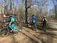
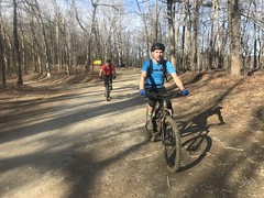
I grabbed some Waffle House on the way up - order scramble well, dry toast, hold the grits... And we all met at the old game check station lot off of FS77. "All" being Mark B, Marc Hirsch, Aaron, Aaron's friend Chris (who I hadn't met before), Eddie F (who I didn't recognize without his helmet and glasses), Patrick Jones, and Mike who I'd ridden with before but only knew as Bromley's guy, except that I also knew his name but didn't know that it belonged to him. If that makes sense. It was a popular place. Like 5 other riders came by while we were getting ready, as well as a trail runner. Two guys and one of them's daughter were heading down to Jones Creek to fish it between the lake and FS77A too. Super popular.
It was like 33 on the way up, but the temps were rising quickly. Last minute, I ditched my windbreaker, heavy gloves, shoe covers, and arm warmers, keeping only the base layer and knee warmers. Turned out to be just right.
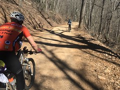
We started by climbing up and over Jones Creek Ridge, then up Winding Stair.
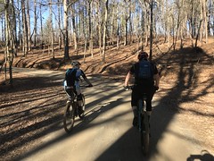
I felt good on both. No trouble keeping up with anyone except Patrick, who was riding a single speed, despite knowing exactly what kind of climbing we'd be doing, and crushing everyone.
At WSG we met the E and a guy who I recognized but who's name I forget, and were supposed to meet Peter Josky. His car was there, but he was nowhere to be found, and after multiple attempts to contact him, we were eventually like "Well, bye" and continued on our way.
At Puncheon Gap, we climbed up Puncheon Knob and dropped down East Penitentiary Cove Ridge. This was obscure trail number one. 15 years ago, it was a barely distinguishable ribbon of singletrack, threaded around and over exposed rock and deadfall. The very bottom was indistinct to say the least. You just had to pick a route through the spindly little trees down there and hope it didn't lead off into to thick brush. The Rangers used it. I rode it. That was about it. These days, a lot of the deadfall has been cleared and the trail is super easy to follow. I even saw what looked like motorcycle tracks. The leaves were thick and deep though, and I mostly rode it in the summer way back, so I'd be curious to see it again in the summer for comparison.
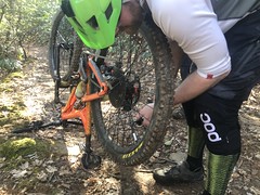
Hopping deadfall was no longer a challenge, but it was still super steep in a few sections. I managed to flat pinging over a rock, and fix it before the next rider came through. As I was fixing it, I noticed an ammo box on a stake about 10 yards away, very well obscured by brush. Super random spot too. I'd never seen it before, and I wondered if I'd ever be able to find it again.
We gathered up at the bottom, headed out to Montgomery Creek Road...
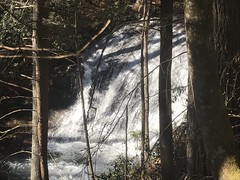
...took the Bee Trail past False Black Falls...
...and rode out past Camp Merrill.
Two Blackhawks were parked on the helipad there, and one was warming up, so we all stopped to gawk. Some locals with a jeep were there too, as curious as we were.
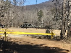
We watched for like 5 minutes, but they never took off, so we crossed the Etowah and headed toward Cooper Gap Road. I managed to get a foot wet crossing, not because of any clumsiness, but because I was like "ok, it's shallow enough to stop ratcheting now..." but it totally wasn't.
Fortunately the temps were still climbing. It was at least 50 on the south side of the ridge, so it never really presented a problem.
The Blackhawk did take off though, right as we were passing the entrance to the camp, and it was really cool. It popped up, started moving forward, then dove to tree level as it climbed up the valley to Hightower Gap. I met some Rangers at Garrett's Farms once that called it "map of the earth" navigation or something similar. Where they basically hug the terrain to wherever they're going. I'd seen almost the exact same thing from Hightower Gap once. A Blackhawk followed the valley up to near the gap, then headed up the face of Hawk Mountain. It's surreal when you see it. I can't make it sound nearly as impressive in words as it is in real life.
Post-spectacle we climbed Cooper Gap Road...
Just past the "Sky Orchad" we ran into another guy who hadn't ridden it before and was happy to hear that he was getting near the top.
At the gap there were a bunch of folks camping where the AT crosses, and some motorcycles passed us from the east.
We reorganized and headed west, only to stop again at the quarry for a couple of quick photos.
"The Night Watch" style:
And traditional:
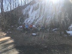
Darn sun, right in my face the whole time.
From there we hit the Ace of Spades, or Horse Gap Road Connector as I'd been fond of calling it. Eddie O had to bail there to go find the guy he rode up with. Eddie F bailed somewhere in there too, but I forgot exactly where. The rest of us carried on. I could not ride the hideous chunk on my 80mm 2.2x26'er but everyone else on their 120+/100+ 2.7x29'ers had an easy time of it. Actually, Hirsch rode it on his hardtail. I'd ridden it before, but it was a very long time ago, and I just didn't see a line this time.
On Horse Gap Road, there was a guy walking his dog. Of all things.
Chris had flatted, couldn't get the Stans to seal it, and eventually had to put a tube in.
We took Horse Gap around Greasy Mountain, to a trail that I'd never ridden before. It's on old topo maps, but I'd hiked it end-to-end way back, and it was nearly impassible, even on foot. So much deadfall. Since then, enough of it had been cleared to be nice and rideable, and what remained was basically exactly what you'd do on purpose, in a road-trail-conversion. A happy accident, I guess.
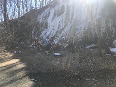
We crossed Cochran Creek, hung a left and climbed up to Edmonson Gap. About 80% of that was rideable, but the top 20% was a difficult hike-a-bike. Difficult, mainly because of the freeze-thaw. On the shady side of the various ridges, there was a slip layer. The top 1/4th inch was dry, but that just insulated the 1/4th inch below that, and kept it from drying out, so the next 1/4th inch was wet and slippery, and the top bit would slide along the bottom bit with enough pressure.
Terrible!
Unrideable. Even hiking was difficult and slippery. Our feet were all slipping and chewing up the soil. All of this right along the creek. Worst conditions to be on that part of the mountain in. I felt irresponsible being there. I felt bad about my impact on the forest. Under different circumstances I'd have turned back.
When we got to Edmondson Gap it was fine for a while. The slope was north-facing. There was a more hike-a-bike on the way up and over to Frozen Knob, but a lot of it was rideable. Somewhere in there, my glasses went flying off of my helmet as I hopped over a log, and Patrick ran them over. Of course he couldn't have seen them, so it wasn't his fault. And, it didn't do any real damage. I just straightened the nosepiece, clipped the lens back in, and they were fine. That's the one really bad thing about my helmet, it just won't hold glasses, and I hate wearing them while climbing. I'm thinking about somehow putting some little rubber strips on the temples for a little extra grip.
Coming down off of Frozen Knob was ridiculous. I've always called the trail that leads up Frozen Knob from Williams Gap, and over it to the gap above Gooch Creek Cove the "Frozen Knob Trail." Well, these days, the bit of it that drops off of Frozen Knob proper down to Williams Gap is referred to as Mario's Run. I'd hiked it forever ago, but never considered riding it. It's super steep and rocky, and short of hike-a-biking up Mauldin Knob, dropping down to Edmonson Gap from that side, the hike-a-biking up to Frozen Knob Ridge, I could never figure out a way to even get to it. And the trail between Frozen Knob and Greasy Mountain doesn't actually go all the way to Greasy Mountain. It kind of fizzles out about 2/3rds of the way up. So, I didn't think much of it. Somebody did though, and while not exactly popular, it definitely gets some traffic these days.
At any rate, it was also north-facing, and incredibly slippery. Like touch-the-brakes-and-lock-up-both-wheels-then-put-a-foot-down-and-that-foot-starts-slipping-then-put-another-foot-down-and-that-foot-also-starts-slipping slippery. Me and Mike basically jogged next to our bikes down about 60% of the trail. I could finally ride the last 40%, but even that was sketchy.
We regrouped at Williams Gap and apparently everyone had been having trouble, though most fared better than I did. I'd like to hit it again in the summer when I have a chance at riding it.
We hit Frozen Branch next. I immediately got a big chunk of mud in my eye, had to stop, got passed by Mark B and Chris, and struggled to catch back on. There was a time when I was fast. Seems like a long time ago now though.
From there, we climbed up, past Rock Creek Lake, to Hightower Gap. Water was blasting over the dam at the lake. Some people were fishing. A little past that, there was a truck parked on the side of the road, and a guy and a lady were poking around on the downslope. They both had grocery bags that appeared to be full of something, but I couldn't tell what. It didn't look like trash. They didn't appear to be picking up trash. No idea. In the bed of their truck though, there were two young girls, like maybe 4 and 5. Maybe younger. They were very excited to see us coming, and the younger one ran to the tailgate and was like:
"Hello! My name is Stacy and my sister's name is Violet!"
Maybe not Stacy... Some "S" name.
Her slightly less extroverted sister smiled kind of nervously and waved.
I replied with: "It's very nice to meet you!" and she seemed very pleased with how well it all went, smiled really big, and danced a little.
The whole exchange was heartwarming. The guys behind me were like: "What was that all about?" They couldn't hear what we'd said, they just heard us both talking, then saw her smiling and dancing.
Ha!
It was a bit of a grind up to Hightower, and a bit more of a grind over to Winding Stair Gap, but we all made it. Nobody bonked and nobody had to walk.
Me and Patrick almost caught two dudes in black jerseys at WSG. They were barely ahead of us. I figured they might stop at the gap and we could say hi, but they just kept going and bombed right down it.
After a quick regroup, we bombed down as well. I caught and passed Patrick, but then managed to front-flat (and thankfully not crash) about 2/3rds of the way down. Dangit! I'd already flatted once, and I was fresh out of spares. I had to patch that one. Fortunately Hirsch and Patrick stopped to help out, and the repair went quickly. Good thing I'd brought two CO2's.
Done!
Woohoo, Blue Ridge WMA! And it only took 12 years and dramatic advances in technology to get those guys out there. There are a dozen more trails back in there, and routes that don't include the ones we rode last weekend. I wonder if they'd be interested in any of those?
Back the lot, I ran into Stan Crane! No work party that day, so he'd been out riding too, and ran into some guys in Jeeps on some of the trails off of FS877. They were planning on doing some work the next day, but I had family stuff to do and it didn't work out. Hopefully March 2nd works out better. I haven't been able to do any digging for months now, and it's been pretty discouraging, actually.
On the way home, we all stopped at Johnny's Pizza in Dawsonville. The restaurant was full of smoke from the kitchen, for some reason, and the sun was just above the horizon, beaming directly into the booth we got by the window. The guys on the other side of the table had to wear sunglasses to be able to see. I got a chicken parm sandwich with no cheese. Sounds crazy, but it was just crazy-good.
I wasn't all that tired on the drive home, but I slept really well that night and could only manage a 45 minute recovery hike the next day.
Good times, good times.


Mario's Run is actually the trail from greasy mountain down to edmondson gap then it hangs a left and heads towards edmondson pond area. Some guy works on the trail up there and its all more defined now where edmondson gap trail connects to greasy mtn trail. Conditions were better up there this past weekend. Some moto guys passed up at the top of Frozen Knob and I think they went down towards little frozen knob and we went down to williams gap. We used to ride down those steep rocks really fast but it's super sketchy now and I slow way down before I hit the steepest part.
ReplyDeleteDavid, I have spent a few minutes on your trail site and strava trying to trace this route. Do you happen to have GPX from this particular outing? I am trying to become familiar with some of the unofficial trails. Thanks!
ReplyDeleterob dot kelly at ung dot edu