I used to ride all over the Blue Ridge WMA, all the time. By "used to", I mean like more than 15 years ago. The trails that I used to ride aren't system trails. In fact, most of them predate the system, and many of them predate the National Forest itself. I discovered some of them by just noticing them. Others by looking at the map the Ranger candidates carry around. Others by looking at old topo maps circa 1889. Being non-system trails, though not outright illegal to ride, they are not, by any stretch, ideal to ride, at least from a sustainability perspective. As such, for the past 15 years, I've ridden them pretty rarely. Like once per year, and for the past 10 years or so, just as a matter of course, it's been even less than that.
A couple of weeks back though, the rare opportunity to get back up there presented itself, and I really felt like taking it, so here we go...
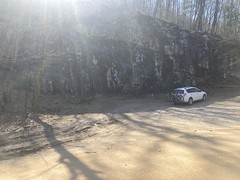
When riding the Blue Ridge WMA, one generally parks at the Mt. Zion Church, across from Camp Merrill, and heads up FS80 to Cooper Gap. I parked there, and was almost immediately joined by a guy with a motorcycle in the bed of his truck. The parking lot is notched into the hillside, and there's a retaining wall in front of the church that's the perfect height to unload a motorcycle. I've seen people use it for that a few times over the years. We joked about how someone must have been planning ahead when they built the lot.
From there, I began the climb to Cooper Gap. I've probably climbed FS80 more than any other road in the NF. I love that climb.
A little over half way up, there's this chimney off to the right.

I can't tell you how many times I passed it before I finally saw it. Seems hard to miss now.
Right before it gets steep, you pass a house, which, for a while, was pominently named "Sky Orchad". I guess someone let them in on their mispelling though, as that time, the sign was missing. Google Maps still shows the mispelling though.
A lot of cars passed me on the way up, in both directions. The AT lot at the top was full, and a bunch of people were milling around. I'd gotten a late start myself, and I was surprised to see other people getting an equally late start.
There was a truck at the quarry, with bikes on the back.
I didn't recognize the truck, bikes, or riders, and they were intently studying something on their phone as I passed. I don't think they noticed me at all.
The road was fast and fun. In the summer it gets really dry and loose. In the winter, it gets soft. It wasn't any of those. If anything, it was a little chilly on some of the downhills, being north-facing and all, but I was kind-of happy with that, as it was otherwise a little warmer than I'd expected.
I passed Horse Gap, Mauldin Gap, and Hightower Gap. I felt very comfortable on the descent to Hightower Gap. It usually feels loose and sketchy, but not this time. I realized at the time that I don't think I've ridden any of that stuff on my current bike. I wasn't sure if it was the bike, the conditions, or a combination, but it felt better than I remembered.
At Puncheon Gap, I noticed a sign: "Illegal Trail..." and threatening language indicating that motorized use would involve a mandatory court appearance. Defintiely a new sign. Unless the laws have changed a lot, and recently, then there's actually no such thing as an illegal trail, only illegal use of the forest, some of which could be construed to be illegal trail construction or use.
That said, I knew why the Forest Service was upset. I'd ridden that trail a few years back, and it was in comparatively bad shape. 15 years ago you had to know what you were looking for to be able to follow the trail at all, you had to hop or carry over quite a few downed trees, and there was no discernible trail for the bottom hundred yards or so. Since then, it probably gets dozens of riders a week. It's really well defined, all the downed trees have been cut out, and I imagine the average rider isn't as light on their back brake as I try to be. Worse though, motorized riders climb it. And by "climb it", I mean spin their back wheel all the way up the steeper sections, piling up duff to either side.
I'd have taken photos, but I didn't feel like stopping, and it just made me sad anyway.
I guess it's what I should have expected though. It was kind-of like that a few years ago, and the trail just runs right down the ridgeline. Gotta carve the mountain, people. Carve the mountain.
On the way over to FS141, I noticed an ammo box that I didn't specifically remember.

It's a super old orienteering marker for the Rangers. It's either always been there, and my memory is failing, or it was moved from somewhere else. Their modern markers are a lot fancier.
Speaking of Rangers...

I was looking for a connector trail. It should have led northeast from FS141, over to the Puncheon Gap Trail (old FS141A). On my map there were 2 little spurs to the south and across from the first one, a trail leading north that bent around to the east. I explored all of this in the early 2000's though, and these days, one of the spurs to the south is now a food plot, and to the north, it had been logged pretty heavily and the woods was trying hard to grow back. I couldn't find the trail or any remnant of it.
That humvee was parked right across from where the trail ought to be, and just downhill from it there were like 5 rangers hiding off to the downhill side of the road. They looked super anxious. I ended up riding back and forth on that section of road a few times, looking for the trail, and passed them three times in the process. I'm sure they were expecting "the enemy" at any time, and seeing me probably gave them a good shot of adrenaline every time I rode by. Sorry guys.
I planned on climbing The Puncheon Gap Trail (Old 141A), but didn't want to climb it from the very bottom. A few years back, no trespassing signs went up all over, in the vicinity of the base, including two near the bottom of the Puncheon Gap Trail. Historically, you could ride all over the base. There was even an official mountain bike loop in the late 90's, and a marked jogging loop more recently. I went on base a few times to get a look at the Rangers' map and I talked to the CO extensively about the trails once. But that was before the signs. It seemed like they might only apply to a few hundred feet of the trail, if even that, but I didn't want to risk it, so I rode down to the guard house at the base, and talked to the guard on duty. Turns out they won't arrest you if you're on base property. Depending on what you're doing, where, why, and for how long, they may just ask you to leave. If they have to ask you to leave several times, then they'll "get more serious about it", but probably still won't arrest you. The guy even described the areas that they really care about, and that little bit wasn't one of them, so I felt reasonably OK about cutting across it.
In the old days, the first mile or so of the road would go through cycles of being perfectly graded, then developing a two foot deep rut down one tire-track or the other, eventually becoming completely impassible by vehicles, then getting graded again. The presence of the rut, and the accumulation of pine needles and deadfall seemed to indicate that it may have been finally abandoned for good, but I guess we'll see what the coming years bring. At the end of the formerly-maintained road, it gets super steep, and the old roadbed lies many feet below grade. Way back, when trees would fall across it, the dangling branches would get cut out, and it wasn't always completely impossible to ride. I was able to climb the whole thing once, but usually only had to walk under a downed tree once per attempt. No longer! The tangled mess of downed trees was extremely difficult to get through. I walked the entire thing, crisscrossing back and forth from one side to the other, over and over. "Strenuous" is inadequate to describe it. That trail that I'd been looking for used to tee in just below the top of that steep section. I found the location, but the trail was indiscerible. Interestingly though, it looked like someone had excavated the backslope there. I hadn't noticed it years ago, but having seen all those mine cuts at Pinelog, it really stood out.
Interesting!
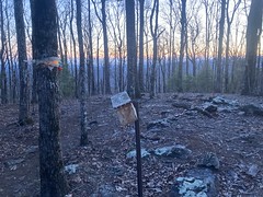
There's a bunker at the top of the climb.
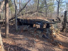
It's been there forever, and I've seen it many times, but apparently never got a photo of it. I've only ever seen 2 other bunkers in the vicinity of the base. One on Conner Mountain, and I don't remember where the other one was. I wonder if they're still there. I wonder if there are more somewhere.
The trail itself is pretty steep. Way back, I'd usually ride it as a downhill, but of the various trails between FS77 and FS80, it and the Hightower Express are the only ones that are even possible to attempt. So, I'd occasionally try. I used to ride it on my triple-ring 26er, and I had plenty of gear with a 34 in the back. I never tried on my 26er when I had a 1x11 - 34 up front and 11-52 in the back. I've got a 29er now, with a 1x12 - 32 up front and 10-51 in the back, and I felt a little under geared. Just a tad, compared to the 26er. I need to redo the math on it. It seems like I ought to have right about the same gearing, but maybe not. It certainly felt like I didn't. Maybe I'm just getting old.
The trail was super, super braided, but really, it's always been like that. The old roadbed was always discernible, but it was rarely the worn-in route. I could see some evidence of motorycyle use, but nothing compared to East Pen Cove Ridge. It looked like mostly foot traffic.
Partway up I ran into another old orienteering marker.

I remembered having seen that one before though.
There's a little knob about 1/3rd of the way up, with a grid of 2-foot tall metal stakes all over the top of it. I'd forgotten about its existence until I saw it again. There used to be a huge spool of barbed wire lying next to the trail with a blue ribbon on it too. I looked for that, but didn't notice it this time. I have no idea what the metal-stake-grid is. The only thing that even comes to mind is a live-fire course, where you have to crawl under barbed wire with live-fire going over your head. That's a boot-camp thing though. I wouldn't expect Ranger candidates to have to do that. Also, I'd expect a backstop of some kind. I wouldn't expect it to be on the top of a knob. Who knows though?
Near the top, it becomes a rhodo jungle, and back in the day, you had to keep an eye out for a white ribbon, and bear right at that ribbon. The ribbon was long gone though, and I ended up bearing left on a trail that I'd been on before, that goes straight uphill to the East Pen Cove Ridge Trail. Not the direction I wanted to go. Fortunately I recognized all of this, and whacked east until I found the other branch. It popped out of the rhodo onto a pretty nice sidehill that I followed for a while.
The sidehill leads to Puncheon Gap. In fact, old enough topo maps show the trail as a well-maintained road, leading up to the gap. The road leading up to the top of Hawk Mountain starts immediately across FS42 from where the sidehill hits Puncheon Gap. I always wondered if they were ever contiguous - like if that's the road you'd have taken to get to the lookout tower. The map I have predates FS42, but also predates the Hawk Mountain tower, and I don't have a map that shows all of it together. I don't imagine anyone's still alive that could answer that question either.
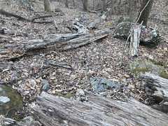
I stopped climbing about 1/3rd of the way up the sidehill, and whacked downhill through this...

...to the head of the Puncheon Express Trail.
I managed to aim pretty well too, and ended up only about 20 feet from the top of the old roadbed.
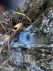
I'd consumed one of my bottles, and there was an ideal spot to refill it there, so I took the opportunity, just in case.
I've never been able to ride all of Puncheon Express. There are always downed trees, and there's one spot where there was once a bridge, but it's been gone since like 2004. There's also "the chute" which is like 300 yards of steep trail, filled with like a foot of leaves, year round.
The downed trees were especially prevalent this time.

I probably never coasted more than 200 yards, all the way down.
I did notice a waterfall that I'd never noticed before.

Toward the bottom, the trail started looking a lot more well used, and the connector over to Hightower Express was completely free of debris.
I noticed a rock pile to the north, that I hadn't seen before as well.
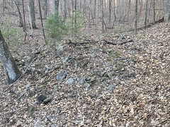
It looked unnatural at first, like mine tailings, but after climbing all over it, maybe it was natural. I don't know. I didn't see any other indication of a mine nearby.
I also noticed that the connector went through a pretty deep cut in one of the little spurs coming down from the ridge. I hadn't noticed that in the past either.
The Hightower Express was clean and largely free of debris and downed trees. The rangers use it a lot though, so I guess that's to be expected. I didn't immediately notice any indications of motorized use, but it was honestly a little hard to pay attention. Again, I felt just a little undergeared.
My inability to pay attention hurt me too. About halfway up, you can bear left, or bear right. The trail is equally clean in both directions, but it really looks like you ought to go left. If you do, it gets extra-steep at the top, and then the old road bed ends and you have to take a really steep kick up to where you should have gone.
I ended up doing that.
The mistake did make it possible to examine the other side of the creek though, and I noticed another, very distinct roadbed on the other side. I couldn't tell how overgrown it was, but man, it was steep. Much steeper than this side. I couldn't really see where it came from, I just kind-of noticed it was there, eventually. Way back, I'd explored a old road that paralleled Hightower to the west and eventually became too overgrown to keep following. Maybe it kept going and became that road that I saw. Who knows? That same old topo map that I keep mentioning shows the Hightower Express as being the main drag in the area way back. I can imagine it got rerouted several times before eventually being abandoned. So steep though. Hard to climb on foot, even. The idea of "going over the mountain", even on a road, must have been a pretty daring prospect in those days.
Finally.

The climb from Hightower to Mauldin Gap, on FS42 is one of my least favorite, but that's usually because of how loose and/or soft it is. The condition of the road was so perfect, that I really didn't have a bad time of it, and was surprised by how quickly I climbed it. If there was a Strava segment there, I'm sure I'd have PRed it.
The sun was getting low, and it got pretty darn cold as I approached the quarry. In that area, it's always pretty to the north, late in the day, this time of year.

The photo doesn't really do it justice.
The Ranger map used to show (and probably still shows, actually) a trail leading from the AT, down the ridge of Sassafras and Conner Mountains. I don't remember where it went at the bottom end, but way back, I tried to find it, and with less than 50 yards of whack, was able to pick it up from just around the first corner at the bottom of FS80. It was really easy to follow for quite a while, but I would always lose it where Conner Mountain started getting kind-of steep. I later found an old logging network leading from FS142, up the west side of Conner, to an exposed slab of rock on the ridge, and there was a bit of a trail leading in both directions, but not enough to follow for more than a few hundred yards in either direction. I eventually gave up trying to find it, marked it overgrown on my map, and went about my business. Well, apparently, some years back, it became a lot more discernible, and riding it has become a thing.
Some educated guessing led me to believe that I could gain access to it from above the quarry, and in fact, I could. I'd only been up there once before, on foot. At the time, modern topo maps had shown a food plot up there, and the trail from the top of the quarry led to an area of denser vegetation than the surrounding forest, which I guess might mean that it had once been cleared. But the trail petered out into all of that, and I didn't try circling around to find more of it. I did notice though, that there was an old, narrow roadbed above the quarry, paralleling FS42, and I'd followed it in both directions a little bit. Since then, I've seen that it goes and goes to the west, eventually joining and then diverging again from FS42. It makes me wonder if it was the original route.
But I digress...
I pushed up above the quarry. Yep. Trail. There was also an old metal stake up there, that probably had an ammo box on it, ages ago. The trail meandered up to the top of Sassafras and crossed the AT. I actually shouldered my bike and crossed the AT in one step, as not to sully the sacred path. Heh. The last time I was up there was with my brother, on that hike where I got that wicked metatarsal tendonitis.
But again, I digress...
From there, it was almost all downhill.

Though the trail was in much, much, much better shape than East Pen Cove Ridge, I still felt a little discouraged riding it, for many of the same reasons. It was, undeniably, a lot of fun - fast, kind-of rocky, plenty of logs to hop, some had rocks that you could send... but, it mostly followed the ridge line, and where it's especially steep, it's already getting worn below grade. You can kind-of see it, a little bit, in that photo even, and that's a not-particularly steep section. I did see some evidence of motorized use, but it didn't look like the whole trail had that characteristic spinning-all-the-way-up look to it. When that's been happening, you tend to see long tracks of loose dirt piled up to either side of the trail as the bike swings back and forth under the rider, rooster-tailing to either side the whole time. These get kind-of washed down by rain, but over time, they accumulate, and there's usually evidence of it having happened recently. Normal use of a steep trail just loosens the soil in-place. The soil washes directly down the trail and you eventually get accumulation where the trail turns. That's what it mostly looked like to me. It doesn't just happen on downhill mountain bike trails though. It happens on any trail that's steep enough for the force exerted by typical taffic to overcome the shear strength of the soil. In my experience, in North Georgia, for a mountain bike trail to be even vageuly sustainable, it has to be under 10% grade if it's not ideally placed (eg. a fall-line or ridge trail), or a half-backslope sidehill under 15%, with short kicks under 20%. Otherwise, even normal traffic will perpetually loosen the soil, water will wash it downhill, the trail will become a funnel, the impact of water will get magnified, and the trail will just steadily eat itself below grade.
There are a many examples of this happening to roads in the Blue Ridge WMA itself. It happened on Hightower Express, but was eventually mitigated by the roadbed eventually exposing so much rock that the average shear strength of the soil is just below that of rock. It's hard to say where that will happen, or how deep the trail has to dig before it happens.
I guess... The trail was fun, but with the level and type of traffic it's getting, it's not sustainable, and I'm not a huge fan of that. On the upside, it follows a ridgeline, so it's as far away, as possible from any stream. The only streams it could even possibly impact are the high headwaters of the Etowah, and the Etowah is much more affected by Camp Merrill's leech fields, old garbage dump, and developed areas downstream than by sedimentation.
So... ehh...
All that said, there were, actually, long sections of it that were shallow and reasonably sustainable. But! There was also one steep section, where I was like "Goodness, people ride that?!" I walked. I'm not ashamed. It was just too sketchy for my XC/BP rig. Maybe if I had a dropper post... Or a proper bike... Or proper skills... Or broken ribs fewer times in my life... Or some other excuse :D
There was another ammo box up there somewhere.
And the sunset was glorious.

Again, the photo doesn't do it justice.
The very last bit, where you hang a left and drop down to the road was super sketchy. It looked rideable, and I even stopped to examine the drop to the road itself before just going for it, but with the failing light, I couldn't see that you drop down, then flatten out a bit, then drop again. I didn't see the second drop until I'd committed to it not being there. It wasn't a huge problem, but my seat whacked the crap out of my crotch, and I was lucky I didn't rack myself to death.
Woohoo!
It was almost officially dark, so I just took FS80 back to the truck, which was all alone in the lot when I arrived.
Ok! Well, now I can say that I've done that! Not sure if I'll ride that last one again, even a year from now, without more capable equipment, and/or skills.


It's too bad there is not more documented history of the old roads and trails up there. It's wild to think that some of that was cleared out and wide enough to drive vehicles on. It seems like it must have been quite an effort to create the roads too.
ReplyDeleteEast Pen Ridge is such a disappointment now. Even just a few few years ago when I first rode it it was in way better shape. I think that was about the same time it started to get moto traffic. I don't have much of any desire to ride it now.
Hightower express is a pretty epic climb. I used to ride it often when the base was more accessible.
That trail down Conner is fun on the upper part but that steep section is a bit much. I can't see it holding up well at all. I walked part of it too. The motos will inevitably find it too.