Oh, the backlog...
Where to begin. Looks like Two Run. Yes, some weeks ago, I rode all over the Cane Creek/Two Run area. This was kind of a reprise to the previous week's Blue Ridge WMA ride, in that it was a bunch of trails that I ride like once per year, at most, and like the previous week's trails, it had been way more than a year since I'd ridden them.
I parked at the church again, and recognized a truck parked down the road a bit. I'd seen the same truck the previous weekend. It's quite recognizeable because it has some kind of rear bike rack that you can hang 4 bikes off of, vertically. I have no idea what that rack is. I've never seen it except on that particular truck. Pretty cool.
Instead of climbing FS80 like I usually do, I actually headed downhill to old FS879, crossed the creek and headed up that trail. In antiquity, it went maybe a quarter mile back before becoming a good bushwhack, but some time ago it became much more well defined. I hiked it once, while checking out Old Cooper Gap Road, but hadn't yet ridden it. I think most people ride it as a downhill, but I needed to climb, and it was a good opportunity, so, there you go.
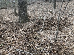
Part way up I found this metal band.

Trash or artifact?
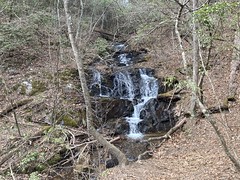
There was also this falls up there that I'd seen before, but it was really raging that day.

Trilliums were starting to pop up all over the place, too.

At the very top, a huge tree has fallen across the old roadbed, and across the spur that the trail becomes, so the current line is straight up the fall line, bypassing the trees. As I was climbing, there was no freaking way, so I ended up finagling my way through the trees. It looked like I wasn't the first person to try that, but it also looked like I might have been the first on a bike.
I popped out on FS80 about half way up an climbed it the rest of the way. At Sky "Orchad" I noticed a trail leading back downhill that I hadn't seen before. It appeared to be skirting the private property signs, in a specific attempt to stay outside of them. While interesting, it was definitely going the wrong direction, so I left it alone. For now.
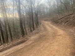
Ahh, FS42. In recent years, I've rarely headed east on FS42 from Cooper Gap, but it was high time, and so I did.

There's some neat stuff over that way. Ward Creek Falls, for example.
To the south, it's the face of the Blue Ridge, and it drops precipitously to the Piedmont. To the north though, there's a bit of a Highlands kind of area. It's hilly, but the hills rise above a large area that sits at about the elevation of Cooper's Gap. Or, at least that's how it seems. I've hiked all through it. There used to be farms and homes back in there. It's still dotted with old fences and crumbling chimneys, not to mention a maze of old farm roads and more recently, logging roads. The AT runs through all of it, but I've only hiked that once. One interesting thing... There's a good bit of American Chestnut back there. It's all stunted, like you might expect, but there's a lot of it. Or at least there was 10 years ago.
I wasn't heading that way though. I planned on diving down off of Hogback Mountain. Like Old 879, I'd last been up there 10+ years ago. At the time, the Ranger map alleged a trail running down the ridge, and I had been able to follow it for a while, but eventually lost it when the backslope got really steep. In fact, to get out of the woods, I'd had to do that "go downhill until you find water, then follow it downhill until you find civilization" thing to get off of the mountain.
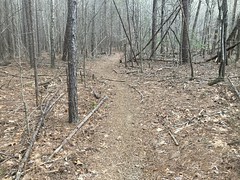
It is alleged that the trail is more discernible these days, and in fact, it was.
But, I did have some trouble with it. I took the old road up to the top, like I had before, only to find trees down every few hundred yards. It looked like blowdown though. The Forest Service hadn't dropped them across the trail on purpose or anything. I could see where people went around them, but it looked like foot traffic. Rangers maybe. I walked most of that. When the road ended, I followed a thin ribbon of worn in footpath up over the top. "More discernible" is not how I'd describe it. But, then, from behind me to the right, a very well-worn trail joined right in. It must lead up from FS42, but I can't explain how I missed it. I guess I just wasn't looking for it.
At any rate, after dropping over the edge, the trail actually carved back and forth across the ridge quite a bit. This was largely due to the need to dodge an abundance of downed trees, but the fortunate side effect is that it made long stretches of the trail into a sidehill, and introduced (however accidentally) many grade reversals. While no paragon of sustainability, it was decidedly finer than EPCR. I also wasn't just full-on deathgripping the brakes the whole time, which was also a bit of a relief. Or, at least, that's how I remember it.
There was an enormous amount of hog rooting up there too.
Appropriate, given that it was Hogback Mountain, but I mean, it was A LOT. More than I'd seen in a long time.
Further down, there were fewer downed trees, and I remember a couple of extremely (to me) steep sections, some of which looked like they'd been climbed on motorcycles. Sigh. Maybe some trees will fall in just the right places.
Do, you kind of ease down for a while, then drop hard, then it eases back up, and you have to jog west a bit. If you lose the trail, it's very easy to end up on some little spur of the ridge, thinking that you're heading down the main ridge. This happened to me however many years back. I figured, with the super obvious trail, it ought to be no problem.
Ha!
Hog rooting.
Where it flattened out a bit, the trail just disappeared completely into the rooting. I could see where people had gone different ways, hoping to find the trail, but all those attempts disappeared into the rooting as well. I ended up swinging increasingly wide arcs back and forth as I descended until I picked up the trail again below the rooting. For a minute, I was worried I'd have to pull that survival maneuver again.
The trail put me out on FS878. A trail led east, but I didn't want to take it at the time, so I headed south on 878.
The trees to either side were marked for logging.
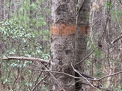
No idea how long ago they were marked. The paint looked super, super old. It's funny. The Forest Service will have a timber sale, some company will come in and mark the trees, then wait like 10 years to actually cut them. In the intervening time, the company might go out of business, or change owners, or the land might get swapped, or some other eventuality. There are trees by Black Branch that have been marked for 20+ years, and every time the company gets ready to cut them, something happens, and they end up not.
This also caught my eye.

"Wrapped around a tree" for sure. Maybe running from the revenuers.
Near where 787 joins with Hidden Lake Road, there was once a trail leading back north, directly over the top of the little ridge there. I intended to take it back north to the top of 787, then hang a right over to the Ward Gap Trail. I found what I thought was the trail and followed it for a few hundred yards, but it dead-ended at a campsite. I couldn't discern a trace of it beyond. It seemed impossible that it could disappear so completely, considering that most of the old roadbeds I follow are like 100+ years old. But, it's not a sidehill, and maybe some specific effort was made to decomission it...
Looking at the GPS data later, it appeared that I just missed the turn. The campsite trail was some new trail that wasn't there way back, and I just didn't start looking for the ridge trail early enough.
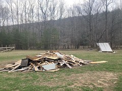
I could either backtrack or follow the old route up through the Hidden Lake camp. Or, Life Teen Hidden Lake as it's now called. I've detailed the controversy surrounding Hidden Lake, and that girl that I'm pretty sure I saw escape before, so I won't go into it again here, but it was a weird place, and I wonder how much less weird it is now.
Judging by the debris scattered everywhere, it looked like it might still be pretty weird.
At the back of that field, I found the old trail, and the old sign for the cemetery.

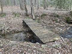
...and the old bridge.
But for a while, it looked like nobody had gone that way in a really long time. The trail was super rocky. Was I still going the right way?
Turned out yes. Much like Hogback, the modern route joined in from the side. I was following the old route.
Healen Cemetery.


With it's weird, low fence.
I'd seen it a dozen times, but never gotten a photo. Always meant to though. Finally!
The Ward Gap trail is pretty steep. Like Hightower Express and the Puncheon Gap Trail though, it's at least possible to climb, and I managed to climb most of it, except where I had to get around downed trees. And, there was an abundance of those. The old roadbed is a bit below grade, so getting around a downed tree means first climbing a few super steep feet up to the grade of the backslope, then getting around the tree. Those first few feet... Terrible.
Near the top, there's such a tangle, that like an eighth of a mile of trail is just bypassed entirely, right up the side of the mountain. Definitely more fun in the other direction.
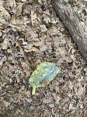
Oh yeah. Mylar balloon. Somewhere on that trail.
Ok. Back on FS42.
Still headed east. This time to Long Mountain.
Same story - ranger map shows a trail, long ago it was broken and barely discernible, now allegedly more discernible. I picked it up where Long Mountain joins the ridge, and it was a lot easier to follow than it had been, though it wasn't super well worn, and quite pine-needly. At some point, it seemed more like it went left than right, so I went left, but apparently in the past (according to my GPS data), I'd gone right. To the left, it followed an old bench-cut for quite a while before rejoining the ridge. More of that "old FS42" kind of thing. One day I'm going to go up there and explore those old 42's. It seems like there really are a whole network of old benches following FS42 from about Mauldin Gap east to who-knows-where. Horseshoe maybe.
But I digress. I picked up the main trail somewhere that I didn't recognize. I only know of 3 landmarks on Long Mountain - this one outrcopping with blue grafitti on it, "the coffin rocks", and a side trail leading down toward Lumpkin Ridge. I eventually found the side trail, but I must have rejoined after the other two. That, or the trail dodges them, which would be a shame.
Long Mountain ridge is not exceptionally steep at any point, and there are some climbs here and there. I don't remember the trail being chewed up by bikes or motorcycles at any point. But, honestly, I don't remember a lot of detail about the trail, except that I got wicked arm pump from descending for so long, and that it was a lot of fun - less demanding than the other descents in the area, and I didn't feel like I was in over my head on my XC rig.
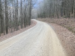
I took the forest road out to pavement and headed further east.

My plan was to climb FS55 up to Horseshoe Gap, hang a left, take FS42 back to Cooper Gap, and drop down back to the car.
It was getting late in the day though...

...and I was on the exact same road that my car was parked on, so it took a bit of will to actually press east, and even more when Black Mountain Road was further down than I remembered. And it took even more when I realized how far up it FS55 was.
It wasn't "dark" but it was definitely "dusk" when I started climbing, and I was a bit more tired than I thought I was.
I may or may not have walked a few hundred yards, a few different times.
Ooooh, getting dark.
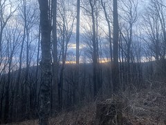
Yeah, really getting dark.
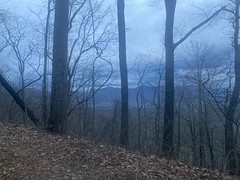
God, look at that though. How often do you get to see a dusky blue sky like that through the trees halfway up the face of the Blue Ridge. It was starting to cool off too, and there was a good little breeze.
Up near the top, it looked like some rocks had fallen "recently".
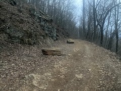
Yeah, just leave em there, they're not hurting anybody.
It was officially dark when I hit FS42, and the only lights I had were my little Spok commuter lights, which are much better for being seen than to see by. I'd planned for this though. I've ridden FS42 in the dark so many times, and that particular stretch has always been a piece of cake. It's a gentle downhill until about Ward Gap, then there's a kick up to Cooper Gap. The gentleness of the downhill makes for good road conditions too, so low visibility isn't that big of a problem. Plus you're on a road, and in the dark it shines white compared to the woods, so it's not too hard to stay on it. You just have to watch your speed in case there are holes or rocks or whatever.
I made it to Ward Gap in good time. There were a surprising number of people on the road at that hour though - a dozen or more motorcycles, and at least 3 cars. The climb up to Cooper Gap was rough. I may or may not have walked a few hundred yards of it, but only once.
The descent from Cooper Gap back to the car in the dark is a lot more dicey than rolling along FS42. I know the road pretty well though, and managed it without incident.
Oh yeah! Another good long one. More fun than the previous weekend, but ultimately longer and tougher, despite involving less overall climbing.
The bright lights from Camp Merrill cast long shadows across the church lot at night - one more thing that's different than I remember.
I tried so hard to find something to eat on the way out. There was no where to park at whatever that Mexican restaurant is on the square. I kept trying, only to find that the spot was the handicapped spot, in 3 different lots, and then there'd be someone walking behind me when I'd try to pull out. It took me like 5 minutes to not park. I couldn't find that other Mexican place that me and Eddie ate at that one time where they gave him that huge Dos Equis. Yahoola Grill was closed. My blood sugar was probably 60 at that point.
I ended up at Roosters, which is usually good. I usually get the Little Hen Strips or something with a goofy name like that, but I wanted a chicken sandwich that night, for some reason, so I ordered that. Aaaah, it came with american cheese on it instead of swiss. Did I read the menu wrong? Did I forget to "sub swiss"? IDK My brain wasn't functioning and I was starving, so it could have been either or both ...and I forgot that they give you pickles even though their menu doesn't mention pickles anywhere, and somehow the pickle makes the fries taste like pickles, even if the fries aren't touching the pickle.
I felt a lot better AFTER dinner, and it was satisfying in retrospect, but on the front end, it was just a comedy of errors, each more painful than the last, but only because I was so hungry.
The drive back was smooth, and I slept so well that night - nothing better than a long, fun, exhausting Adventure, followed by good food, followed by good sleep.


No comments:
Post a Comment