I've been on a kick, lately, of exploring the various trails to the southwest of Atlanta - Douglasville, Newnan, Chattahoochee Hills, Carrollton, etc. I've been hoping to put together a loop that involves some of them, but I figure I ought to know what's out there first.
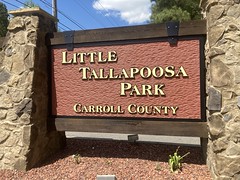
Enter Little Tallapoosa Park.
I'd seen it on maps, and it rung a bell, like maybe I'd heard someone mention it before... I don't know. Seemed like a good idea to check it out. So last weekend, I did just that.
Right away, I was confronted with one of the most potentially-frustrating things a park-goer can be confronted with - a parking fee. $5 no less. I don't mind actually paying the fee, though $5 is on the high side as parking fees go. It's that you almost always have to pay it in cash. Like put $5 in an envelope, tear off your pass, drop the envelope in a pipe, and put the pass on your dash. This was no big deal in the '90's and even early 2000's, but it's 2021. The only people who still use cash are all just trying to dodge paying taxes. I had a twenty on me, and who knows how much change in my "ashtray", but change never works, it makes the envelope so fat that it doesn't want to fit in the slot. Of course I could just cheat the whole honor system and tear off a pass without paying, but only a dick would do that...
Fortunately! The park office...
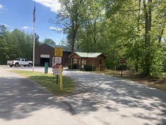
...was right across from the honor pipe, and I could just pay with a card inside.
Faith in humanity restored.
I also asked the guy inside, just to be sure, whether mountain bikes were allowed on the trail, because though the park is listed on many trail sites, the official site for the park just says that there are trails. "Yeah, I think so" was his not-so-reassuring response. Good enough for me though.
I took a photo of the posted trail map too.
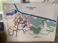
It reminded me of the first maps I made of North Georgia back in like 2001, which would eventually become maps of the TNGA.
I parked in the day use area, got changed, and started milling around. If the system was a clean set of stacked loops, I'd have hit the trails right away, but whenever it's a spiderweb like this one was, I find that it's better to ride the various park roads first, to get a sense of the layout of the place. Then when you end up popping off a trail somewhere, it's hopefully familiar.
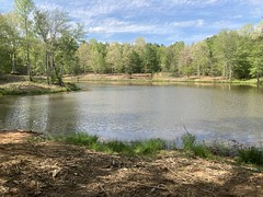
It looked like there were various camping areas - equestrian, RV, and tent, as well as some parking areas - day use, day-use overflow, and equestrian. Also, there were a couple of maintenance roads. There were 2 lakes too, the "Back Lake"...
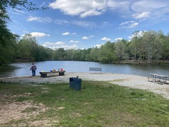
(with a little waterfall pouring out of it)

...and the "Small Pond"...
...which could only kind-of see through the woods until later.
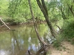
There was also the Little Tallapoosa River, which I thought was Little Tallapoosa Creek until checking later. Full-on river, it turns out.
I did find a traihead sign that mentioned bikes, so I was somewhat more reassured that bikes were actually allowed there.
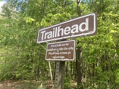
Though, it didn't specifically say that they were allowed on the natural-surface trails, so who knows, for sure?
The first proper trail I hit was this paved trail.
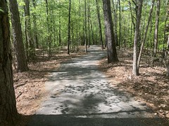
There are 2 stacked loops of that, which run all around the interior of the park. Lots of people were out walking on them. I passed a kid on a BMX bike riding the other way down by the river, but I didn't see anyone else on a bike all day.
The natural-surface trails were extremely difficult to decipher. There were many more than shown on the map. Some of the ones on the map weren't there, and a lot of them started at the back of a campsite. Like you literally had to walk through someones campsite to get onto the trail. I only found those by coming the other direction after picking the other end of it up.
The trails themselves were a mix of singletrack...

...doubletrack...
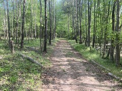
...and unmaintaned roads.
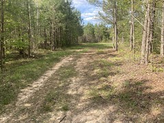
So, along with the paved trails, they get an A+ for diversity of trail experience. But none appeared to be purpose built. Most that I found looked like old strip-cuts and just worn-in stuff.
I did see some trail markers, here and there:
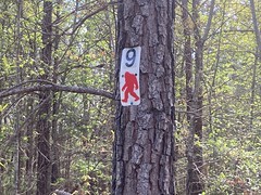
But after spending like 3 hours failing to make sense of it, I finally ran out of time and headed out. I had dinner plans with friends, and I wasn't going to cancel just so I could keep turning circles in the woods.
Oh yeah, one last thing... On the way in, I'd noticed this road sign, so I got a photo of it on the way out.

Heh. That's me. Old Muse.


No comments:
Post a Comment