Yesterday was my birthday. Happy birthday to me. My Dad says I'm getting seasoned, but that I shouldn't feel bad about it because I can always say that I'm not yet as seasoned as he is. Ha, ha.
It was also Presidents Day so the girls were off of school, but since they had gym and dance all day I couldn't reasonably do anything with them. Solo! Solo, it is. And therefore I chose something that they would never want to do, ever - climb back and forth over ridiculously steep mountains all day.
I parked at Mauldin Gap. If you've ridden the Winding Stair Loop, you might know where that is. From there, I walked uphill to the top of the knob. There is a "trail" in the vicinity but it sort of comes in from the side and it's not obvious at all except in the summer. In the summer, the hillside is so overgrown with thorns that you can't possibly go any other way, but in the winter it's wide open and clear, and gets a good bit of use by the Rangers, and the shuffled leaves marking the route that they last took up to the top looks as much like a trail as the "real" trail. I don't think I've ever taken the same route up twice.
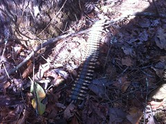
At the top, the shredded remains of this sleeping mat could be found at every turn.
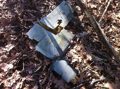
It looked like the wind had had it's way with them. I'm not sure how the mat got so shredded to begin with though. I looked at it for a while. The cuts were extremely geometric. More than I would expect from somebody hacking at it with a knife, or an animal tearing at it either. It made me wonder if the fabric just deteriorates in that way. It is made of threads running along the X and Y axes. It might just naturally fall apart like that.
Weird.
There are "trails" up on top of Greasy Mountain in the sense that you can tell that people have gone that way before, especially in the summer, but in the winter they are somewhat more difficult to follow. Sometimes the leaves just look slightly out of place. I searched for one that I'd seen up there last time and eventually found it. It led to an old roadbed. When that ended I followed more disturbed leaves down into Edmondson Cove.
At the bottom end of the cove there was once a pond, but beavers and weeds have all but reclaimed it. For a while it was renamed the Edmondson Wetland, but recently, somebody just went and removed the sign altogether.
There was a maze of old logging roads, or something near the creek. I'm not totally sure they were for logging though. It would have been a nice place for a farm and there were a lot of old-looking artifacts lying around - coffee cans, bottles, cinder blocks. The roads might just have meandered around the property. The proliferation of stumps on the hillside implied logging, but the lack thereof in the flats implied otherwise. Who knows. Maybe it was both.
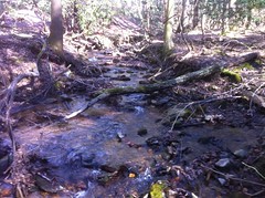
Eventually I made it down to the creek itself, which was much like any other North Georgia Creek. Shallow, clear and cool. Full of rocks. Some of the rocks had moss and some of the moss had lots of other little things growing on up through it. "Ecosystem on a rock" a friend of mine once called it.
I kind-of wanted to explore the entire cove but some of the old roadbeds were pretty overgrown. Others appeared to get frequent use by hunters and Rangers. Unfortunately, it was easy to tell who used them from the trash. There wasn't much trash, but the little that there was was telling. The tear-off part of an MRE wrapper, spent rounds - blanks from Rangers, real rounds from hunters, shotgun shells, beer cans... Beer and hunting seem to go together like bacon and eggs. Every year after deer season there are new beer cans lying in the middle of nowhere and half burnt ones in the backwoods fire rings.
Eventually I abandoned the maze and headed toward the "pond" and the road. Along my route there was a tree with a weird appendage growing off of it.
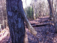
Weird.
At the road there was a truck parked with the engine running and a lady sitting in the passenger seat but no driver. I figured maybe her husband was peeing somewhere. I waved. She waved back.
I took the northern side of the Edmondson Pond Loop back into the cove. With the drying up of the pond, nobody seems to use the trail that much any more. It was more overgrown than anything I'd been on all day. The old interpretive signs were still there though.
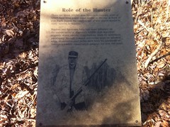
This one was interesting. There may have been 350,000 hunters when the sign was put up, but that's been declining by 10% a year since 2000 in Georgia and the revenue from licenses and taxes has been dwindling. The DNR recently gave up the Blue Ridge WMA (of which Edmondson Cove was a part), instituted general user fees for many of their WMA's and kicked around the idea of renaming them Recreation Areas. The management costs, even above and beyond conservation, were traditionally covered by hunters and fishermen, but there just isn't as much money there these days. If you hike or bike or anything in the participating WMA's, you have to buy a pass. I guess that's only fair. It seems odd to me that hunters were subsidizing it in the past. I had no idea. Of course I have no idea what the breakdown is - how much money is spent on what or where it comes from, exactly. That would be interesting to see.
I cut through the woods to a food plot road and as I prepared for the second significant ascent of the day I heard a rustling in the bushes to my right, down on the trail that I'd just come off of. There was an elderly gentleman with a gun, walking the trail, in the opposite direction. It then occurred to me. I think it's small game season. He must have been the driver of that white truck. "Hang out here honey while I go hunting."
I've seen trout fisherman pull up to a bridge, jump out, cast a few times, jump back in and take off. I've even seen bass fishermen do it at park ponds. "Drive-by's". I'd never seen a hunter do it though. I imagine for small game, it's somewhat effective. Jump out, make a loop around a field, or a pond in this case, shoot what jumps up and move on. I'd seen a dozen or more squirrels already that day. I never heard a shot though, so maybe he wasn't so lucky.
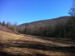
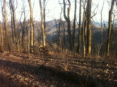
As I began my ascent up the south face of Frozen Knob I was afforded a nice view of Greasy Mountain. I had just come down from there. My car was on the other side at the northern end.
Up on top, it was again clear who spends the most time up there.
Rangers...
...and hogs.
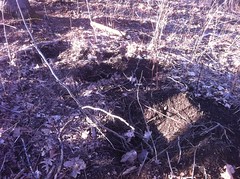
The rooting was indescribable. I say that, yet I will now attempt to describe it. Those holes are about 8 or 10 inches in diameter. If you were to mark out a 20 foot by 20 foot square, there would be at least one set of 2 or 3 holes like that in each square, over the entire top of the mountain. In between you couldn't go more than 3 or 4 inches without seeing a more casual instance. It was like what I'd seen along the road on the way up to Anna Ruby Falls a few weeks back, except over a much larger area. I imagined a herd of pigs, swarming like locusts over the mountain, devouring every buried thing. While I would have loved to have seen that, I would have been terrified to have seen that. On the upside though, the pigs didn't seem to be all that huge. The last time I saw little pits like that they were several feet in diameter with 40 pound rocks casually excavated from them. I could only imagine the beast that did that. This time, there appeared to have been a much larger herd, but of much smaller individuals.
Still though. Wild pigs. Scary.
I headed east and then south to Edmondson Gap. To call what I took down to the gap a trail would again be a very liberal definition of the term. At the CoTrails weekend we had a few weeks back though, we were all asked to define what a trail is and I realized that I tend to define "trail" very liberally. A lot of folks had complex definitions that involved renewal of the mind and spirit and getting exercise and experiencing the outdoors and maintenance requirements and lots of other things. The definition the Trail Dynamics guys has was complex and precise and I remember that it involved the word "facility". My definition was something like "a route where you can tell someone or something has gone before". I don't think my definition will work in a planning or maintenance context, but it certainly works in the woods.
I half expected to see an ammo box on a stick at Edmondson Gap. It looked like a likely place for one, and I'd recently seen one even further out than that. I was disappointed though.
The "trail" back up to Greasy was the steepest yet, and I was on the north face of the ridge so it was cold too. There was even ice on the ground here and there.
My dad called me about halfway up and I sat on a log, facing down into the cove, with a reasonably majestic view for miles around, talking with him for 20 minutes or so about birthdays and computers and auto repair. While that might at first sound like sacrilege, at the time, it seemed like the perfect union of so many of the things that are important in my life.
The trail, vague to begin with, disappeared entirely about halfway up and widened like a delta into the dozens of routes taken recently, only discernible by a footprint here, a trampled thorn bush there, a broken stick smashed down into the ground, an indention on a rotten log, and so on.
Eventually I reached the top and coming out of the shadow, bathed in waves and waves of sun. As I walked, the sun would appear and reappear. When I could see it, I felt 10 degrees warmer.
I headed west to Mauldin Knob. Again, I was afforded another nice view, this time of Sassafras Mountain and the Blue Ridge in general. The AT runs along that ridge.
I managed to find the "actual" trail back down off of the knob. It's super steep, the descent made my legs tired, I'd forgotten to bring a snack with me and all I'd eaten that day was a pair of yeast rolls. I could see my car from almost all the way up to the top but it seemed like it took all day to get down to it.
On the drive in, I'd passed a guy on a road bike on Camp Wahsega Road, a guy on a mountain bike climbing FS80, two hikers at Horse Gap, several people out for a drive, and then there was that hunter and his wife down at the pond. It seemed like the woods up there was the place to be, but on the way out it was definitely closing time and I was locking up the joint. It wasn't quite desolate though, there were a few folks at the quarry, making camp, and a lady pedaling two miles an hour on a hybrid back toward Dahlonega. Her partner was up the road a bit, at a church, with his bike turned upside down, lying on the ground, with his feet crossed and propped up on the top tube. He appeared to have been waiting a while, and by the look of it, he'd be waiting a while longer. I couldn't help but smile.
I grabbed a snack at the gas station and headed home. That night we ate with my brother at Pappadeaux which is one of the few places in Atlanta that has good fried seafood. Mmmm. Fried seafood.
It was a good day. It's been a while since I've crawled all over random mountains. I'll have to do it again soon.


No comments:
Post a Comment