Good lord, I'm sick. Sick, sick, sick. I've got a head cold and it just won't give up. I think it was this past Sunday night, I was up late and over the course of an hour, I went from feeling totally fine to having a total cold. It's terrible. Terrible!
I felt almost good on Wednesday so Kathryn and I went for a little walk in Roswell. We tried to hit the Martin Lake Trail but apparently they don't want none of our kind about.
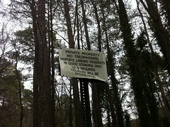
They check ID's. We didn't want to get our ID's checked, so we just walked all over the Wells Tract again. It was... OK.
Thursday morning hit like the proverbial ton of bricks and it was difficult to even get out of bed. The whole day was like that and I fell asleep at like 8:00. It must have done some good though because I was wide awake this morning and feeling about 15% better. Not good, but definitely below the threshold of miserable.
If I'm able to do it at all, a small amount of exercise seems to help with a cold. Maybe exercise is the wrong word. "Activity" might be more accurate. If nothing else, it definitely clears my sinuses. Hoping for that, Kathryn and I went for another walk today on the Oxbo and Historic Roswell Trails.
The Oxbo Trail just parallels Oxbo road for the most part. It can't be more than a quarter mile long. At the west end, it runs up behind some houses and there's all kinds of ancient-looking rubble to either side - bricks, metal and piping. It's right near the Old Mill, so I imagine all the rubble had something to do with the mill. There's a HUGE tree over there too. I have no idea what kind. It kind-of looks like a water oak but I'll have to wait until this spring to find out for sure.
At the other end, Oxbo tees into the Historic Roswell Trail. To the south it enters the Vickery Creek unit of the Chattahoochee NRA via a pedestrian bridge. From the bridge you can get a good look at a dam on Vickery Creek (AKA Big Creek) that Kathryn and I debated the purpose of for a while.
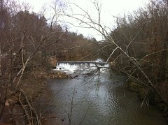
The internet knows nothing of this dam and as we all know, if it's not on the internet then it doesn't exist. Therefore the dam has no purpose because it's not on the internet and thus doesn't actually exist. Case closed.
We took the Roswell Trail north, following Waller Creek.
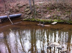
There is some kind of old waterworks at the south end of the creek. Up the hill there's an old concrete tank or something, obscured by ivy and kudzu and surrounded by a fence. Along the bank there are more old structures too - bridge pylons, a weir, some odd concrete tank... I'm sure each of these things had a distinct purpose back in the day. I wish I knew enough to put the pieces together.
The creek itself was really cool. Near the bottom end, it was pretty much one long shoal with little pools here and there. Further upstream there were bigger pools and unfortunately they had collected quite a bit of trash. I imagine when it rains, all the residential runoff just inundates that little valley.
A bike had apparently joined the runoff some time ago. Kathryn pointed it out to me but I didn't even see it at first.
At the northern end the trail joined up with Waller Park and we went walking all around.
They have a skatepark there!
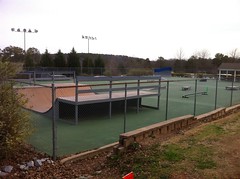
Man! There are skateparks at Waller, Settles Bridge and Fowler Parks, and well-constructed ones too. They're just common features of a modern public park. I'd have killed for that in my teens.
Next door to the tennis courts, they also had a raquetball jail.
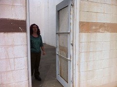
I'm not sure what else to call it. It was a two story, white-painted cinderblock enclosure with a steel door. I literally didn't know what it was at first and all that came to mind was "jail". Kathryn guessed raquetball and that turned out to be right. Raquetball jail.
The trail allegedly continues north of Waller Park and I know I've seen signs for it elsewhere in Roswell but we couldn't find anything that even vaguely looked like more of a trail so we headed back.
There were three different sets of stone steps leading down from the main park area to the trail, so we took one of those this time. It looked like maybe people used to just walk down the hillside and eventually they built steps in the popular locations. The steps looked old, but maybe they were just made to look that way. If so, it was a nice touch.
The creek looked especially scenic at the foot of the steps.
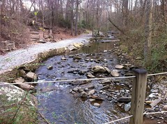
It reminded me of the creek that runs through Life University - surrounded by development but still naturally beautiful.
It was almost entirely downhill on the way back and Kathryn was happy about that. Cold-wise, I felt way better than I had that morning but before we even got home, all the symptoms were back. Hey, it was nice while it lasted.


No comments:
Post a Comment