In the late 90's, if you lived in Baton Rouge and rode a mountain bike then you pretty much had two places to ride: Hooper Road in Baton Rouge - a mostly intermediate course, or Clear Springs in Mississippi, an I-hope-you-don't-mind-dying-in-the-woods course. Then, suddenly there was Liberty. First it was just rumored to exist, then there were rumors of organized group rides and then finally somebody I knew had actually ridden there.
It was a New Trail. Beginner-to-intermediate, and it was fun, and as an added bonus, scenic. I threw it into my rotation and rode there every couple of weeks.
Then one day I got a speeding ticket driving into town in late '99, then we moved to Atlanta, and then I forgot about the ticket. For years and years, I'd find it, put it somewhere that I was sure I'd remember, then just forget about it again. I didn't actually pay it until 2009. Terrible.
I'd only remember about it when I'd visit the in-laws, usually when I drove into Mississippi. Though I'd always wanted to go back, fear of jail kept me from Liberty. And yes, I appreciated the irony of the name.
My debt paid though, earlier today I returned to the scene of the crime.
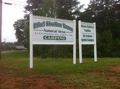
We all called it Liberty because that's the name of the nearest town, but technically the trails are at Ethel Vance Park.
I kitted up and rode to the trail head, started my GPS and read "Low Battery Warning" on the screen. Oops. No problem, I've got spare... Oh... Wait. The spare batteries are already in there. Yay. I'd seen a gas station a mile or so back up the road though, and in a fit of what must be the most backwards logic of all time, feeling too lazy to throw my bike back on the car, I "just" rode to the gas station on my bike.
Twenty minutes later I was back with new batteries and a smile.
Hmmm. I didn't remember routes. It has been 12 years though.
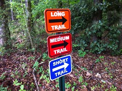
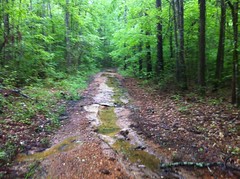
I started with the Blue route. At first it was primo, perfectly undulating, bench cut singletrack, just as I remembered, and it led around the back of a campground into what I used to think of as vertical switchbacks, more accurately described today as fall line climbs and descents. Thirteen years of Mississippi rain had taken its toll though and they were as rutted, chunky and abandoned as one might expect. It didn't look like they got much traffic any more. A shame.
It had rained the night before, pretty heavily, actually, and I was slipping on every root. At the top of a short climb, I reached out to a nearby stump to steady myself and the whole thing gave way and toppled over under my weight.

It turned out that it was just the hollow shell of a stump, barely hanging on, like a loose tooth waiting for an apple.
I moved on. The rest of the Blue loop didn't look like it had seen much use either. One section was so overgrown that I missed it and ended up on some half-flooded doubletrack for a while before circling back and picking it up.
Blue led to Orange and I remembered Orange being mostly flat.
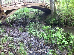
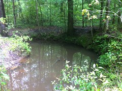
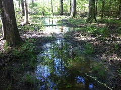
My memory was more or less accurate. It wound around along the edge of various bayous that threaded themselves through the park. Occasionally there was a bridge to get you across. Some of the bridges were big eagle-scout-project-looking structures, others were just old corrugated metal plating haphazardly spanning the gulf.
In particular, I'd remembered one bridge over a huge field of cypress knees and I kept looking for it. Way back it was a sketchy little metal thing and I was always scared of slipping off and getting impaled. Today there was an 8-foot wide wooden construction with railings and I was a lot less nervous.
The field of knees was still there, though I struggled to get a photo that captured it's massiveness.
I wasn't nervous about crossing the gigantic bridge, but it turned out that I should have been. It was really steep, covered with leaves, and not covered with grip tape or wire or anything that might create traction. I had to walk up it and trying to walk down the other side was like trying to walk in that ice in the Canyon. About halfway down I remember thinking "Lean forward on the bike like if it were poles so you don't lose..." Wham! I hadn't even gotten the thought out and I'd already not done what I was thinking about doing and suffered the exact fate I was thinking about how to avoid suffering. Woohoo.
I was unhurt, but also unhappy.
The Orange loop didn't appear to get much traffic any more either. In fact, if there hadn't been plenty of signs and ribbons, I might have had a hard time finding the trail. It reminded me of Lake D'Arbonne, and it was a far cry from it's former singletrack glory.
The scenery was just as good as always though. The cedar trees and the frogs and the slow-moving bayous were all still there.
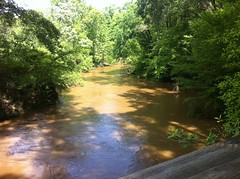
So was the Amite River. Eventually the trail skirted it as well. I'd once seen a herd of deer cross that river not 30 yards up the trail from me. There were no deer today though.
The trail had always gone right up to the edge of the river and occasionally dove down into what remained of little landslides along the edge. Things have changed a bit along the edge there and today, in several places, the trail led directly into thin air.
Two of them had obvious reroutes. One did not. It could well have given way in the storm the night before.
There was an observation tower that hadn't been there in the 90's.
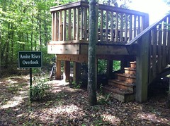
It provided a nice view of the Amite River, which was torrential.
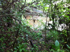
Eventually the trail led away from the river and back toward the park but a loooong section of it was deeply flooded.
Should I ride in the middle and chew up the trail, walk in the middle, get wet feet and chew up the trail or ride/walk on the side and widen the trail? It's like the "paper-or-plastic?" There's no good answer. Oil or timber? I guess these days, both are recycled, so maybe that's not the best analogy. I did a bit of all 4. It turned out that the puddles mostly had solid bottoms and mostly weren't more than an inch or two deep, but I rode in them for over half an hour.
Eventually I got back around to the car. There was still a Red loop though and it took a while to figure out exactly where to go to ride it. The Red loop seemed to get the most traffic and also seemed to be designed the best but it was only a mile or two long and just wound around randomly through the woods, a long way from any specific scenery.
It did have this massive root ball though.
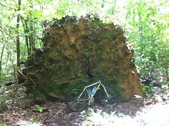
That was cool.
When I got back to the car, I'd ridden around for almost 3 hours and I doubt the system had more than about 10 or 12 miles of trail. I guess I should subtract out the trip to the store and back, and getting dressed. Still though, that's how tough it was to pick my way around the route.
One great thing about Liberty is that the bathrooms have showers, and man I needed a shower. Not only was I covered in grit and spider webs but I hadn't washed my kit since getting back from Florida. It was disgusting and by the transitive property, so was I. Ahh, showers. The hot water even worked.
The ride was anticlimactic. I'd been looking forward to it but it didn't really turn out like I'd hoped. Oh well, sometimes things just aren't what they used to be. That's what I get for procrastinating. I should have paid that ticket and ridden there years ago.


No comments:
Post a Comment