A few weeks ago, Debbie and I got an email from the USFS indicating that some new money had come in for the Bull/Jake system. Debbie's long had a list of work, ready to go, and within a day we'd coordinated and submitted our recommendations. I think it was last Monday or Tuesday then, that we got an email asking if either of us could make it up to Bull Mountain to flag some reroutes. Who says the government moves slowly? If you're proactive and prepared, which Debbie is, they move right along. Yet another reason why it'll be a hell of a thing if I can ever live up to half the example she sets.
I'm busy but my schedule is somewhat flexible, so Friday afternoon Isabel and I met Taylor (the new trail tech) up at the FS28-1/FS77 intersection to go traipsing around in the woods for a couple of hours. We'd recommended reroutes for the bad section of No-Tell, the descent on Jones Creek from the ridge to FS77A, the entire old Moss Branch Connector and perhaps most importantly, some singletrack above Booger Holler to get traffic up off the old, unmaintainable road bed. She'd been up there all morning checking out No-Tell and Booger Holler. We'd have joined her earlier but I had a doctors appointment.
On Jones Creek, there's a road leading up to a food plot on a ridge, some fine trail beyond that and then it deteriorates pretty badly where it drops down to the road.

I know it just looks technical and fun in the photo. It looks much worse in real life. The entire trail is so far below grade, water is hemmed in, runs straight down the trail, and for the most part, there's no hope of creating turnouts. I never noticed before, but the current route is not the original. Multiple, overgrown, parallel, former routes exist up there, each more eroded than the current incarnation.
So, that last drop off the ridge needs to be addressed.
We basically just need a shallower sidehill up to the food plot - probably 10% grade, max. IMO the reroute should reflect the character of the old trail though, as much as possible - mainly, aside from the requisite grade reversals, it should be a straight drop from the ridge to the road. Also, there's a beautiful view to the south from the food plot, a view unique in the system, and the plot itself is beautiful this time of year, not to mention bordered with blackberries, so we want don't want to route around it entirely.
The west side of the ridge gave us the most room to work with and we started flagging the corridor.
I'd walk up a bit, Taylor would check my elevation from the previous flag...
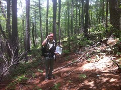
...and wherever it looked good, I'd flag the nearest tree, dangling the tail of the flag to whichever side the corridor should lie. As much as possible, we ran the corridor around trees and usually uphill of them, so as not to expose their roots too badly. We actually found an impressively large oak back in there and ran the corridor just uphill of it.
We joined the old trail at about the mid point of the food plot. Later we realized we'd need to move the end a little further south but that actually made it an even shallower grade, so win-win there.
Where we tied in, there were blackberry bushes everywhere.
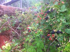
We feasted like no other before us.
Like no other! Mmmmm.
From there, we headed south to survey the trail in that direction. It'd been a while since I'd ridden it. The trail on the edge of the food plot is fine to the north, but to the south, it's deteriorating. From the southern end of the food plot, the trail actually just follows the access road. It's fine at first too, but as soon as it pitches down at about 15%, things go south pretty quickly. It's not super bad, but it's clearly not at equilibrium. The turnouts are all backfilled now too. That road could use a little TLC, from the bulldozer.
Where it becomes singletrack again, the first little descent could use some work, but it's not bad. From there to Moss Branch, the trail is in fine shape. Moss Branch itself is another story though. From Jones, heading east, at first, it's deteriorating, steadily, though not terribly, and there are patches of really nice trail, including a section that appears to just have been worn in and probably never followed any old road at all. But there are two food plots and the trail leading up to the second (in that direction) and then from it out to FS77 is probably the worst section of trail in the entire system. It's deeply rutted, there's one, extremely steep section that's becoming braided and in the few places where there are turnouts, they lead directly into active drainage and you can see the sedimentation it's causing.
I tried to capture the trenched out horror but neither photo really came out. This one kind of did, a little.

Dammit, I need a new case for my phone! Can't see anything through this one any more!
We ran around in the woods for a while, scouting Woody's prescribed reroute. The topo map we had doesn't faithfully relate the complexity of the drainage in there. What looks like a short little draw is really long, drawn out and multi-fingered at the top. Plus, there's an only-somewhat-maintained access road in the area not shown on the map at all.
After exploring for a while, it became fairly clear why the trail was where it was. It's about the only way you can get through there without having to build a dozen little culverts. As it was, they still had to build two.
While exploring, we discovered a sign:

It was chucked off into the woods next to the road, along the route. The Ranger Run route follows the traditional Winding Stair route. Did the Rangers hide it there so they could just pull it out next time, or did some vandal knock it down and throw it into the woods? We have had trouble with vandalism during the Fool's Gold. I wonder.
After crawling around for an hour, the only reasonable reroute we could come up with more or less paralleled FS77, crossing two little access roads in the process. I mean, it wouldn't be impossible to follow the existing route, just higher up the ridge, but it would literally require a dozen or more culverts, rock-armored drainage-crossing structures, or both. And the drainage is active, and leads directly to Jones Creek. Ugh.
We ultimately came up with a strategy. It's easier to draw on a map than describe but it basically the Moss Branch trail could parallel FS77 until right after the food plot access road. Jones, rather than running up that road, could continue across it, tie into Moss Branch and then continue, also paralleling FS77 and gaining elevation until it loops around back of the food plot, ties into the existing trail right above where it goes bad, come back south then switche back right at the beautiful view and join the trail we'd flagged earlier.
Maybe. There are a list of possible issues with that strategy. We'll have to vet them out before we do any flagging.
The day was wearing on and I had to get home. I had an adventure race in the morning, needed some sleep, and my mom was coming over to pick up Iz.
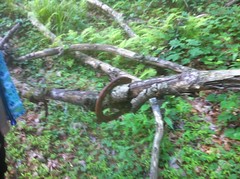
On the return hike we found a lucky horseshoe.
We also found a dozen or more unspent blank rounds like the rangers use. I always wonder how it is that they lose unspent rounds. I find them all the time. I can understand ejected shells, but unspent rounds? Did someone nervously spill a box while reloading during a mock firefight? Again, I wonder. I probably do enough wondering for three people.
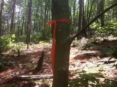
We left Taylor at FS77A. She headed home and me and Iz headed over to the Bull Mountain Lot. We had one final mission to accomplish. More than a month ago I put up a bunch of red stickers marking the "red route" up around Bull Mountain. I was two stickers short though and Debbie got me some more a week later or so. Since then, I've been up there a couple of times and always forgot to bring the stickers with me. Not this time though! We walked out and applied the last two stickers. For some reason Iz wanted to jog back to the truck. At first I didn't want to, but I figured with all the jogging I'd be doing the next day, it couldn't hurt.
On the drive out, the biggest timber rattler I'd ever seen was sunning itself in the middle of FS83.
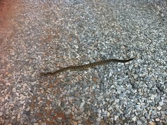
We both got out excitedly to look at him but upon reaching the front bumper of the car, some 15 feet away from the snake, Iz realized she didn't want to be any closer. I was a little braver, and possibly a little more foolish, but I got a decent picture of it and that's what really matters, right?


No comments:
Post a Comment