A week or two ago I went running around in the great unknown east of Bear Creek and, as usual, found all kinds of old roads leading off into who knows where. Actually the USGS might know where, if their old maps can be trusted, and my inner-explorer wanted to know if they could be, badly. This past Tuesday was a slow day at the office, I had an opportunity to satisfy my curiosity to some extent, and at about 4PM I was parked at the last available spot, way up near the top of Whitecliff Drive.
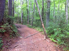
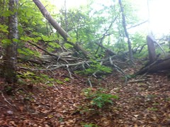
The road continues up from there but the last time I tried to go any further, I had a little trouble with this precariously balanced log...
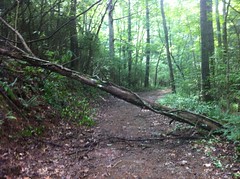
...and ultimately with this log as well.
This time, on foot, they were no problem.
Just past that roadblocking log lay an old cabin. It didn't look like anyone had occupied it lawfully in a while, but it also appeared that plenty of explorers, with less respect for the law, and less fear of angry landowners than myself, had occupied it less lawfully, recently.
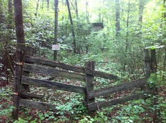
I wasn't curious enough to check it out myself.
The road ahead led into the National Forest. Despite its non-existence in their inventory, and except for that fallen log, which appeared to have been there for quite some time, it was pretty well maintained.
Eventually though, it led to an inholding and I could go no further, ahead at least.
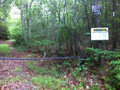
The map showed the old road leading directly ahead, all the way up to the White Cliffs of Fowler Mountain, and given that the road was named Whitecliff Drive, I figured it might actually go there, but I couldn't follow it any further. To the left though, lay a ray of hope. At first I thought it was just a fire break, as it led directly uphill and consisted of little more than a long series of 4 foot humps, one after the other. It was reasonably clean though - no ruts, mud holes or even discernible tire tracks, but it got enough of some kind of traffic to wear away the duff. On the left hand side there was a whole line of WMA boundary signs. On the right, signs marking private property.
I proceeded cautiously uphill.
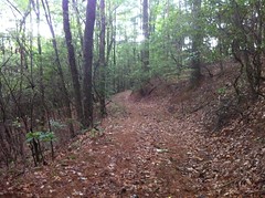
Eventually that road teed into another at the ridge. It was overgrown down the ridge and really clean and clear up the ridge. The private property signs were gone but there were still plenty of WMA boundary signs on my left. Before long the road diverged from the ridge itself and sidehilled the west side.
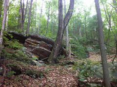
There were a lot of interesting rock formations up there but I struggled to get a decent picture of any of them.
Almost imperceptibly the road narrowed and blended into the backslope until eventually, it was nothing more than a footpath.
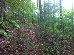
The blending and disappearance was unusual. It looked like once the road was abandoned, the backslope began to slump into it, bit by bit, and the steeper the backslope, the more it had slumped. As fate would have it, this meant that the further down the road, the more it got filled in. Maybe the weight of all those rock formations had something to do with this too. I wonder. I think I've seen this phenomenon once before, on the trail to High Shoals falls. I remember debating with myself for a while about whether the High Shoals trail had ever been a road at all.
The footpath sidehilled to a ridge and disappeared entirely.
This was actually fine with me because it had been leading away from where I'd hoped to go for a while. I'd seen what might have been another trail a ways back, a pair of them actually, and in terms of direction, they looked much more promising - they led directly up Rattlesnake Lead. In terms of passability though, it looked waaay less promising.
Both trails were several feet below grade, somewhat overgrown, and innundated with deadfall.
The trails wove back and forth, intersecting each other several times and forking minor threads which wove back and forth between them. Presumably the more deeply trenched trail, which led directly up the ridgeline, was the original route and the meandering sidehill was the reroute. It was not unlike lower Bull Mountain, below the Y. The main difference being that the reroute on Rattlesnake Lead was much steeper, had no grade reversals nor any erosion control structures of any kind. I guess its possible that they'd long worn away though. Given the similarity to East Mountaintown Creek and the number and narrowness of the little side threads, it had the feel of a once-important road that, even after a reroute, became impassible to vehicles but continued to be used by horses until, after a few more attempted reroutes, it was eventually impassible to them as well, at which point it was abandoned entirely. That's really just a guess though. I'd love to know for real. Somebody knows! But the likelyhood that I ever will is slim.
It was exceedingly difficult to follow the old trails. Exceedingly. It was much easier to walk through the woods on one side or the other.
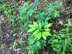
I did discover something interesting though - a 5-fingered leaf of Sassafrass.
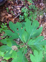
I hoped that it was lucky, like a 4-leaf clover. I've never seen one before or since. I discovered it while carefully negotiating a massive, steadily rotting blowdown that crumbled and buckled with each step. Maybe it was lucky.
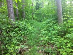
Eventually the ridge shallowed out just enough and the old road was substantially less eroded and despite being overgrown with everything a trail can be overgrown with, was reasonably easy to follow. Way up high, when the ridge flattened out, the trail disappeared. I used my imagination though: "Where would it have likely been..." and eventually found it again.
There was another major reroute as it clawed its way up Fowler. The old route didn't look worn out at all though. Had the road originally been built for horses and eventually rerouted to be wide and shallow enough for vehicles?
There was a ton of Wild Azalea up there. It was beautiful.
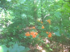
It's been a while since I've seen any of that.
The map showed the trail meandering its way east up near the top but the trail I was on was headed north toward Halloway Gap. I looked hard for any semblance of anything headed east. If there was anything there, I couldn't find it. It's entirely possible that I missed something though. It would have been easy to do.
Despite having bushwhacked for miles up an obscure old, nearly impassible road, there was clear evidence that I wasn't the only one who'd gone that way recently. Way up at the top there was a very clearly worn-in line along the outside edge of the road.
It was really intermittent though. People or deer? There were no revealing tracks of any kind.
Abruptly, the trail petered out into a big field of ferns, surrounded by a dense thicket of rhododendron. I've seen this kind of thing before. I bet there was a clearing there once. It took some searching and some imagination but eventually I found traces of the road again, and then, voila! The Benton Mackaye.
To the north, it looked like the road continued and they just used it for the BMT. To the south the BMT diverged sharply uphill and looked like purpose-built trail. I headed north and the BMT followed the old roadbed for a long time, diverging into a sidehill when the road went directly up over a knob, then eventually returning to it again on the other side.
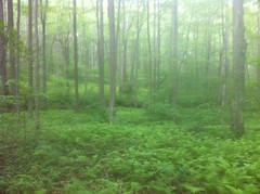
The BMT up there is beautiful. Grass and ferns abound. There are all kinds of odd little flowering plants up there too, not to mention Azalea, Rhodo and Mountain Laurel.
And it doesn't appear to get nearly as much traffic as the AT.
Initially my plan was to head north, look hard for a connector over to Jack's River Road, take that, work my way up over Sassafrass Gap somehow, come back down East Mountaintown Creek and either take the road back around or if I was feeling lucky, take the FS road up to Loggy Flats and nav back to the trail I'd been on way earlier.
I realized how dumb this plan was when I checked the time and the map. I didn't have anywhere near enough time. In fact, I had almost as far to go north on the BMT before the next turn as I'd gone already that day. Worse still, it had started storming. Lightning was striking all around me and the thunder was deafening.
I had no hope of carrying out my plan. It was time for a direct abort.
As abruptly as it had started, the rain disappeared, but it left it's mark on the landscape.
Leaves glistened.
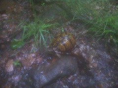
Turtles came out.
I saw three separate fire newts within 10 yards of each other.
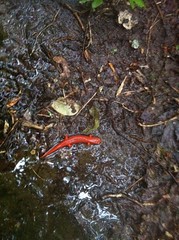
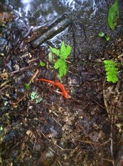
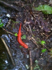
And just the other day I'd realized that I hadn't seen one in a while. Now I've seen a year's worth.
The descent was a lot faster and easier than the climb. A LOT. I even made it back to my car before dark.
I guess the hike was somewhat interesting, but it was a little disappointing that it didn't go where I thought it would and I didn't see much wildlife except tiny little animals. I hoped to see the actual White Cliffs but it would appear that the route I took doesn't actually go there. Also, when I got home, I looked hard at the map, overlaid the USFS boundaries over it and realized that the entire section of the trail along Rattlesnake Lead passes through an inholding and isn't on USFS property. It's not marked in any way, it could be state or county land, but you never know, and that kind of thing is always sketchy. I guess it's good that the trails up there are nearly impassible - I won't be too motivated to go back up that route again.
There's still plenty of stuff to see in the Great Unknown. The woods is a big place. Perhaps next time it'll be a little more interesting.


No comments:
Post a Comment