Ye Olde Rope Mill!
Kathryn fled to Baton Rouge Sunday morning to help her family move, taking the Gerch with her but leaving me the Iz. My brother and a bunch of my friends were meeting at Mulberry Gap Sunday morning for an early ride but Iz needed to meet my mom later for a sleepover with her cousins. Having worn myself out the day before at Jake Mountain, my mind could barely handle the complexity of this situation. I wanted to go for a ride somewhere but I couldn't figure out how to make it work up at Mulberry. As luck would have it though, the Padre was still in town and meeting up with him would kill many birds with one stone. Thus, I did.
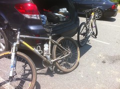
We met at his place, handed off the Iz to my mom and burned up the roads between Smyrna and Woodstock.
In the Olde Rope Mill lot, our bikes waited anxiously like a dog at the back door, eager for walk.
And we walked them all over the place.

"Walk" might be an inaccurate metaphor in this case though, as the Padre was noticeably stronger and faster than last time we rode at Olde Rope Mill, several weeks back. He's been in Georgia for a few weeks now, had his climbing legs back, and it was awesome. Just like old times.
We spun a full loop and this time I didn't forget my GPS, so now I have data for the Explorer Trails and updates for the Avalanche trail. What I really wanted to do though was explore the trails on the other side of the river.
The last time we were there, we poked around over there but we weren't motivated to do too much exploring. This time we were.
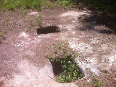
Almost immediately across the river lie the ruins of the old mill itself:

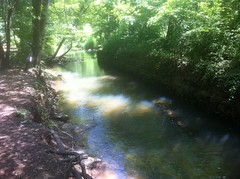
The last time we were there, we were a little confused because it looked like the river flowed south, but if it did, none of the mill structures made any sense. In fact, the river flows north. Why had we thought it flowed south at all though? How could we get something that presumably obvious wrong? Standing in the parking lot, looking out at the river, if you watch the leaves on the surface of the water, they do indeed, slowly move south. We double and triple and quadruple checked this. There was no wind to speak of either, and we watched it for a long time, so it wasn't just wind blowing leaves upstream. If you move further upstream though, the water can be seen flowing decidedly north. The only explanation that I can come up with is that the Little River is lower-lying and contributes far less water to Lake Allatoona than its other tributaries. If the lake is high, which it is, and if it has rained recently, which it has, then the Little River gets overwhelmed and water actually flows into it, against its own flow, as the lake rises. I guess that's what's happening. I can't come up with another explanation. It was satisfying to know that we weren't just imagining things last time though.
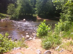
This time, we continued south, past the ruins and off into the unknown, or at least into the unknown-to-us. At first the trail ran directly along the edge of the river but eventually it moved inland and appeared to follow a drainage or sewer line. There were a dozen little side trails but we left them alone for the time being.
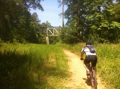
We kept running into other people. Mountain bikers, walkers, dog walkers... It seemed that these trails were fairly well known to the locals. I was a little surprised to see a train trestle materialize in front of us. I didn't remember crossing any tracks on the drive in.
Past the trestle, the trail was a little less travelled but we still ran into the occasional family or dog walker.
Way out past the trestle we rode through several sand pits and it reminded me a lot of Florida. Apparently I learned something down there because I had little trouble negotiating the sand and when I did have trouble I was able to correct it, whereas my dad couldn't have kept moving if his life depended on it. Yay, sand.
When we reached Main Street, we headed back. The trail kept going though. For all I know, it follows the river all the way up to it's origin. I'll have to discover the truth of that some day, though the City of Woodstock may beat me to it. They're working on a Greenprints Project to build multi-use trails throughout the city. If you look at the map, it looks like the trails we explored will eventually be developed in some way; maybe gravelled, maybe paved. It looks like they're planning on putting in more singeltrack all around there too. Woohoo!
On the way back we explored some of the side trails. I could probably spend a day or two out there decoding the maze. Maybe someday I will.
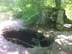
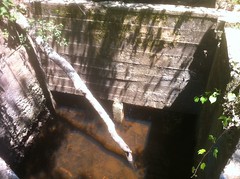
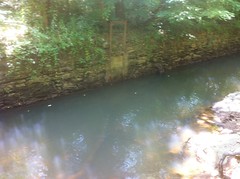
We'd noticed an old dam of sorts on the ride out and stopped to look at it on the way back...
I'd forgotten the name of the paved trail on the other side and hadn't looked at that Greenprints Map in a while, so I'd forgotten that the name of that rock pile is "Trestle Rock". So, was there a trestle here at some point or was that little dam constructed from the rock that composed the supports of the old bridge north of there, the ruins of which now lie beneath the new bridge in the middle of the park? I could imagine that a light gauge rail might have run where Rope Mill Road now lies, and it would make sense for the mill to have been built near the rail, or vice-versa. I'm sure that somewhere in Woodstock there's a pile of old maps and photos and other information about all that. How does one go about finding such little treasures?
Speaking of Rope Mill Road, we took that northeast when we got back to the bridge, but it ended at a construction site of some kind. I wasn't confident that it wasn't private property so we didn't venture into it. I'll have to check it out from the other side though. If it's not private, it could make a Rope-Mill/Blankets-Creek Big Loop a lot more feasible.
When we got back to the lot, we were not yet satisfied with our wanderings and spun another lap around the Explorer Loop. Nothing is more satisfying than fast, rolling singletrack after trudging up steep old dirt roads and plowing through miles of sand.
I dropped my dad back at his place and we talked at length about retrocomputing before I left. He wasn't too hungry so we didn't eat together, but I was starving and for weeks now, I've been hoping for an opportunity to eat at Dee Thai. I used to eat there about once a week when I worked in Alpharetta and their Pad Kee Mao might be my favorite food. No. Their Pad Kee Mao IS my favorite food. There's no "might" about it. The kids don't like Thai though, neither does Kathryn, and it's unusual that I'm by myself on a weekend. The stars were aligned though and in short order I was presented with a plate of tangible joy.

Of course, my phone washed out the color so it's true beauty can't be appreciated in that photo, but the experience was not unlike reuniting with an old friend. It's been way too long.


No comments:
Post a Comment