I have this old map of the Upper Chattahoochee from 1980 that shows a few features that aren't shown on modern maps. One of these features is a trail running along, or in the vicinity of Trail Ridge. With a name like Trail Ridge, one would expect there to be such a trail, and over the years, I've seen indications that there might be such a thing.
FS44B forms the "Jasus Creek Loop", which heads north from FS44, meanders back and forth along Trail Ridge, crosses Jasus Creek way up high and then meanders back down along some unnamed ridge before teeing back into FS44 not too far from where it began. This road is almost always closed, it's a tough climb on a bike, and, being a road, not much fun to hike. As such, I haven't been up that way too often.
But! This past weekend, I did go up that way, and it turned out to be one of the best hikes I've had in a while.
The drive up was somewhat interesting. I made good time until I got into Helen. Cars weren't backed up all the way to Sautee, so I figured it might be possible to drive through town instead of around it. Turned out that I was sort-of right about that, but not entirely. The Shriners were in town, getting ready for a parade. There were motorcycles everywhere, and those tiny little cars that they drive, and people lined up all over the place in lawn chairs, waiting for the festivities to begin. Said festivities had not yet begun, but traffic was still backed up a bit with all the staging and with everybody finding a place to park and get a good seat.
It was a bit hotter than it's been, low 90's, an there were fewer people up in the woods than usual. I saw a few people fishing, but nobody camping. I don't think I saw another car, moving at least, all the way up FS44.
I parked just up the road from the Jasus Creek Loop, gathered my things together, and got moving.
The initial climb was tough and steep, and there was fresh gravel down too. As slow going as it was, I was glad I wasn't on the bike, having to wrestle that gravel.
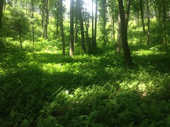
Trail Ridge and the next one to the east have really taken a beating over the past few years. Between tornadoes, logging, and prescribed burns, there are a lot fewer tall trees and the brush is super, super dense.
The upside of all of that though, is spectacular views.
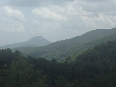
That's Mount Yonah, to the south. From other spots along the road, there are good views of the Blue Ridge and Locust Log Ridge. And you don't just get a glimpse here and there, you can see them for a while.
After climbing up to the ridge, the road bounced back and forth over it. At each gap, I searched for indications of a trail. I mean, the ridge is named "Trail Ridge" right? One would expect there to be a trail, on the ridge, and the map seems to show that too. But, the map was old and hand-drawn. It was pretty accurate for being old and hand-drawn, but not accurate enough to really pinpoint the location of the trail.
At each gap though, I did find indications that people had gone that way before. If I didn't immediately run into a wall of saplings, then at the first downed tree the trail would start to get cold, and after the third, it was gone. If could see the ground, I might be able to discern an indention, but in the middle of the summer there was just no hope of that. Maybe in winter. Or maybe not at all. Honestly, I wasn't confident that what I kept finding even added up to a contiguous trail at all.
While slightly discouraging, another, much more discouraging thing, was the bugs. Good god. The bugs. Everywhere. Not mosquitoes, but little buzzing gnats, buzzing around my ears to no end. I did all kinds of experiments to try to keep them away though, and here's what I discovered...
My hair isn't long enough to pull down out of my hat and cover my ears. Covering ones ears tightly makes it difficult to walk. Covering ones ears loosely does nothing. Somehow, the bugs still know they are there and are only very slightly less annoying. Strangely enough, putting your hands in front of your ears, perpendicular to them, hides your ears entirely. For some reason, bugs can no longer find them. But, then they just go for your eyes. Waving ones hat over one shoulder and map over the other works well, but you have to do it constantly. Neither poplar, various oaks, nor sassafras seem to be natural bug repellents, even if shredded up, but if you wave a sprig full of leaves, of any of those, like a dorky little fan, over each shoulder, constantly, it's effective, and less of a pain than waving the hat/map combination. I walked around for most of the rest of the day, carrying these two little sprigs of poplar, and waving them over my shoulders whenever the bugs would come back. I can only imagine how ridiculous I looked.
There was one good thing though... The ridge is named Trail Ridge, but it could just as easily be named Blueberry Ridge.
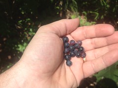
It was thick with them. I ate like 5 or 6 handfulls and eventually just got tired of eating them. There were plenty more. Plenty more.
Another good, or at least interesting thing: lizards! Dozens and dozens of lizards. They were all along the margins of the road, sunning themselves I guess, and they'd scurry off if I got within 5 feet. One didn't scurry too far though, just hid under a tuft of grass. When I lifted the tuft with my foot, it ran off, right across my other foot. Ha!
Another good thing, or maybe dubiously good thing... That whole area is bear country. Big time. And I was starting to see signs to that effect.
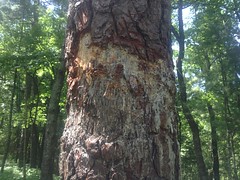
Yeah! Someone's been marking that tree for a while. I like how the claw marks are clearly visible coming down from the top.
Shred.
That tree was just north of a wildlife planting. From the planting, I got some good views of Locust Log Ridge.
At least I think that's what that is. Definitely some part of the Hickorynut Lead.
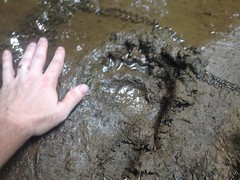
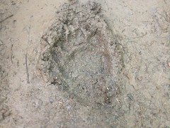
Back on the road, there was more bear sign.
A small print...
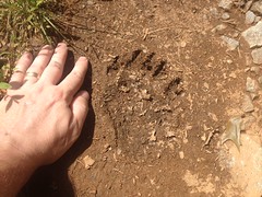
And larger prints...
But bears weren't the only notable thing up there.
There were puddles full of frog eggs.
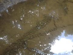
I wasn't sure what those were at first, actually. At first I thought it was one of those strings that you get if you start pulling on the corner of a piece of carpet. I had to look close to see the individual eggs.
There were really old campsites here and there too. The fire rings were scattered, and all the trash was from the 80's.

I guess it's been a while since that road's been open for long enough for people to camp off of it.
I did find a fairly new looking firebreak way up at the top of the loop, and walking along it, saw a mother bear and three cubs about 200 yards away from me. They'd seen me first though, and I only saw them after they'd started running away.
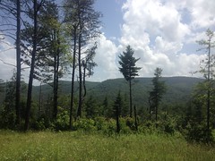
The woods was ferny and beautiful at the higher elevations.
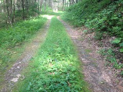
The road itself was fairly scenic too.
Where the road crossed the upper prongs of Jasus Creek, I found a trail leading up along, between, and across them, to a wildlife planting.
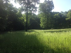
There were millions of little white flowers growing everywhere. Sophie's favorite flowers. I wish she could have seen it. She could have picked all that she could carry and wouldn't have made a dent in them.
The road to the planting led over from FS44C.
Near the intersection, my brother called me. I was surprised to find that I had service, but apparently I did. He'd been in Florida all week, he was about to go ride, and he wanted to see if I was around. Unfortunately I was decidedly, not around, but we made plans for next weekend. Hopefully those will work out and I'll have something else to write about next Monday too.
While kind-of kneeling there, talking to him, a coyote crossed the road in front of me, and headed uphill on 44C. It didn't even glance in my direction. I tried to get a picture of it, but dangit, I wasn't quick enough.
Pretty good though. 4 bear, a coyote, frog eggs and a bunch of lizards. Kind of made up for not having seen any other wildlife yet this year.
At that point, I was officially nowhere near where I needed to be. I was about as far from the truck as possible, and taking 44C back to it would definitely be the long way around. I'd so far avoided large-scale, cross-country bushwhacking, but it looked like a bit of that might be in my future. The last time I was up there though, I'd made note of the road leading to the wildlife planting, and another trail adjacent to it. Both were marked on my map. The coyote seemed to have come from the direction of that trail. It looked like it might lead at least sort-of over in the direction I wanted to go... Yes. It did. It was another firebreak, and it led directly back to 44B. Score.
So I was now back a the top of the Jasus Creek Loop, closer than before, but still darn far from the truck. Should I continue around the loop? Backtrack?
No. Option C.
Option C was to bushwhack along Jasus Creek itself and cut back up over the ridge if that turned out to be convenient at some point.
At first it was really easy going. There were little game trails here and there that were pretty easy to follow. Now and again I'd end up on a bench for a while too, but it was never clear whether it was man made or natural.
Eventually the backslope got really steep and I had to climb and climb just to give myself room to recover in case I slipped. Then it got to be hands and feet. Hands and feet. And finally, I could see ahead of me, the densest tangle of rhododendron and magnolia known to man. Or, maybe unknown to man. It seemed unlikely that man, in general, had been in the vicinity for a long time. Both sides of the creek were choked with it, all the way up the ridge, and the backslope wasn't any shallower.
Down at the creek, there were a series of small cascades.
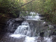
The creek itself was choked too. It wouldn't have been any easier walking down it than walking through the woods to either side.
Might be time to try to get back up over the ridge.
I climbed up through the rhododendron, emerged, and found myself on an old logging skid, or maybe an old firebreak. It appeared to end a few feet from where I'd found it. In the other direction, it must lead to something.
All right!
But, first things first. I was getting hungry, and I had both a Tabasco Slim Jim and Whatchamacalit in my pack. Mmmm, hmmm. Lunch time.
It's one of my favorite things... Sitting on a rock, in the middle of the woods, having a snack. Sure, yes, there are plenty of better things, but that one is pretty good.
The skid led to an old road. The old road had a distinct trail on it. In fact, it looked about like the Hickory Nut, only not as steep. There was about the same amount of deadfall, same amount of rock, same amount of overgrowth. It meandered along below Trail Ridge, on the east side, just like 44B did on the west. I followed it south. There were two short overgrown spots where trees had fallen and exposed the trail to the sun, but after pushing through each of them, the trail was as clear as it had been on the other side.
I made great time, but I kept expecting the trail to end abruptly at some point. I'd hiked all the way up 44B and hadn't seen it tee in anywhere. After a while, though I had to be getting close to 44B, I could see that I was approaching a gap, and I was starting to see good evidence of the burns. Just as I'd given up on the idea that the road was going to end, it did, abruptly, as if the bulldozer had stopped right there. I looked back though, and there was a really, really well worn trail, leading right up to that spot. The heck?
After poking around for a few minutes, it started to seem like there'd been a landslide. It looked like some trees had fallen and they'd been the only thing holding the ground in place above the road. I carry my GPS to map stuff, but I rarely use it to see where I am. In fact, I don't even have a topo background loaded into it. I took a look though, and at the zoom level that it was set to, it looked like I was on 44B. I was close, less than 50 feet away, but ahead of me there were downed trees and the landslide they'd caused, all exposed to the sun, covered with new brush, and especially, with thorn bushes. There was no good way to get below it. Above it was thick with the same kind of brush. I ended up spending about 10 minutes just picking through it, one step at a time. On the other side, the road was right there. I even recognized where I was. I'd seen that spur on the way out but from the other side, it just looked like maybe the guy building the road had started going that way and changed his mind.
And it was then that it occurred to me. Maybe that road was the trail on the map. It roughly fit. All day, I'd been looking for a trail ON the ridge, but maybe that's not what the map intended. Maybe I'd finally just stumbled upon it, accidentally.
I'd run into it in the middle too. It keeps going the other way. Hmm. I guess I'll have to go back and see where it goes some day.
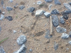
On the way out I saw tons of turkey prints in the sand.
My right knee was bothering me too. It used to do that sometimes. I'd all but forgotten about it. I guess I've got roadie knees. Until a few months ago, I'd been on the road bike, almost exclusively, for like a year. I've managed to ditch the roadie legs, but not the knees, it would seem. More miles! I've got a fever, and the only cure is more miles!
Back in Helen, I ate some good Chile Colorado at La Cabana. Aside from myself and a few others, the restaurant was filled with a single group of people. They had pushed about 6 tables together, and more of their group was sitting at satellite tables. A group that big is usually super, super loud, especially if they're drinking. Not these guys. They were all deaf. The restaurant was amazingly quiet, quiet enough that you could hear them signing. I could hear people talking outside. It was surreal.
Aside from getting kind of sleepy and grabbing a Mellow Yellow in Dawsonville, the drive home was as uneventful as the drive up.
Heck of a day though. Miles and miles, blueberries, lizards, bears, a coyote, and a lost trail! Yeah-heah!!! That's why I do it. That, right there.


No comments:
Post a Comment