My brother has been traveling a ridiculous amount lately. It's actually been kind-of difficult to get a hold of him. When I can, he's highly motivated to ride, but not so highly motivated to drive very far to do it. He calls it "windshield time." "I don't have a lot of windshield time in me this weekend." I can definitely understand that, so we've done a lot of road rides around his house. But, every now and then, he DOES have a bit of windshield time in him.
As he did today...
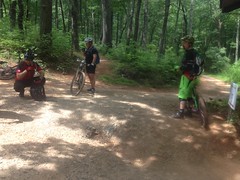
We met Marc Hirsch at the almost completely full Jake Mountain Lot at about 9:30 AM. There was room for like 1 additional car after we arrived. Cars and trucks faced the entire perimeter. There was even a short horse trailer parked over by the big gravel pile.
It was decidedly, the place to be.
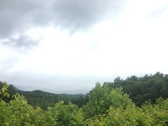
The campground was empty though. The weather forecast had been sketchy. 50% chance of rain. No, wait, 20%. No, 50%... All week. It was dry and sunny when we arrived, but we'd seen some darker clouds and haze to the north on the drive in. I can imagine not wanting to commit to a weekend up there with those odds.
The blackberry bushes around the edge of the lot were starting to get red, and there were even two ripe berries.
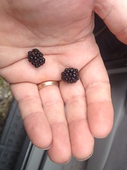
Ye-eah, first blackberries of the year.
The port-a-john had a new sign at the back, or at least one that I hadn't noticed before. About halfway down, it read something like: "There are only 3 things that go in this portajohn: URINE, POOP, and TOILET PAPER. However much fun it might be to throw things like cups and cans into it, please don't..." I laughed out loud when I read it. Just, the creative way it was written... Ha!
Marc was about 30 minutes early and so we got on the trail earlier than we expected. Conditions were perfect. We were having a great time. I've been burning laps around Allatoona Creek for weeks now, trying to get my skills back. That last ride up at Rope Mill and Blankets was pretty validating in that regard, but these are the real mountains, and no amount of spinning laps on local trails can prepare you for the real mountains. A few miles in though, I was cautiously optimistic. The trail felt good. I seemed to be paying attention to the right things, and making the right decisions.
All right.
We climbed Bull Mountain proper.
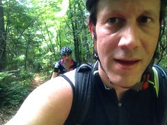
It felt just like I remembered. No idea if I was climbing fast or slow though. Marc was always right on me. But that doesn't tell me anything, he's well known to be faster than I am.
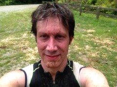
We stopped at the truck for the obligatory photo.
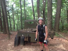
Marc took two photos, actually, and both came out blurry. The next photo I took was blurry too though. I'm not sure that the blur had as much to do with the photographer as it did with the disgusting layer of sweat that the camera had to try to focus through. It wasn't terribly hot, but it was terribly humid, and the profusion of sweat had nowhere to go except into my clothes and all over my phone.
It was nasty.
We paused, momentarily, at the top of Bear Hare and then began our descent. For the first 300 yards it seemed that my downhill shred was up to par. But I should have capitalized "seemed" in that last sentence because at yard 301 I flatted. Oh yeah... Got to be a little more wary of rocks and roots at god knows how many miles an hour. Forgot about that. And I wasn't naturally, unconsciously wary. That's what I'm talking about: real mountains. Not such a problem at Allatoona.
So, I got to fixing the flat... My tires are still kind-of new though, and not so easy to get off the rim. I've always been successful at getting tires off without levers in the past, but I guess I never flatted this early into a new pair before. Marc loaned me a pair of pink tire levers though. The first thing I thought of was: "It'd be hard to lose those." Like my phone in its purple case... Pink levers. Somebody had a good idea.
Since I was there last, the old-roadbed part of Bare Hare is now largely a foot-wide ribbon of trail with tall grass and other shrubbery growing to either side, all the way out to the edge of the road. It was still armored with gravel too, and it looked strange and unfamiliar, like some piece of archaeology nearly swallowed up by the jungle. It had just barely started to get like that the last time I rode it, which had to be back in 2012. Man. Time flies.
Around the back side of Bull, there was new signage that I didn't recognize, and a NEW TRAIL! Oh, man, a NEW TRAIL! Or, at least, new to me. To say that I was excited would be an understatement. "Elated" comes closer. Not sure what the right word is, really.
The old road we'd been using since forever ago was a mess. Straight up and down the fall line and 5 or 6 feet below grade. The the little creek that crosses it that was a perpetual mud hole and reliable source of controversy. There'd long been talk about putting a trail in back there to get users off of the road, but I had no idea that it had been done.
But it had been done. And it was luxurious. Ahh, el luxurio. They even managed to run it up the back side of a little spur and avoid crossing that creek altogether.
Win.
It looked like the Whoop-de-doos Trail had been curtailed as well. They now ended at the new trail rather than bombing down to the road. Ironically the trail's name is now invalid, as there are, in fact, no longer, any whoop-de-do's, on the trail.
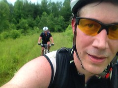
Heading back around to the bottom of Bull, we passed a blonde girl on a Niner. Lisa Randall? We all thought maybe, but none of us definitively recognized her. The last time I thought I recognized someone was on a local road ride. I called to him and chased him down, only to find that he wasn't who I thought he was! As awkward as it was not to have said hi, I, unfortunately, don't have to imagine how much more awkward it would have been if we had, and it wasn't her.
We hung a left and headed out toward the dam, and Jones Creek Ridge.
There were more dark clouds to the north, and it looked like it might be raining over that way. Maybe.
The lake behind the dam was no longer recognizable as a lake. Tall trees now filled it completely. I remember when I could clearly see the creek, and I remember when I could clearly see the overflow. Those days are long gone. What's the story with that dam, anyway? It's massive. The lake that could be backed up behind it would be huge, if it was ever allowed to fill in. Did it ever fill in? Were there plans to develop that land, like maybe make a state park or something, that fell through, or was it just built for flood control? Somebody knows! Tell me!
There were more surprises on Jones Creek Ridge. A reroute that Isabel, Taylor (from the USFS) and I had marked most of back in 2012 had been built right up off of the dam. Again, I had no idea it had actually been built! Singletrack bypassed the food plot and teed into the original trail on the ridge. When we marked it though, we weren't super sure how to tee back into the trail near the dam and left that bit unflagged. I guess someone figured it out, but I'm not so sure it's holding up all that well. There's some fairly steep trail leading up from the dam, and it's getting pretty eroded. The soil there is really sandy. It's possible that the grade might have been ok if it had been clay. We didn't have any trouble riding it, but I'm not sure how long it's going to last. The rest of the trail was the same opulent luxury we'd observed earlier though.
And, then!! At the next intersection there was yet, more new singletrack. The entire Jones Creek Ridge Trail from there on had been relocated to the north, as a sidehill, rather than running directly down the ridge. Again, Iz, Taylor and I had marked about half of that trail, and yet again, I had no idea that it had been built! We'd originally planned to tee into the original trail at the middle of the food plot to preserve the view of Campbell Mountain, but we couldn't get the grade right. I guess they solved it by circumventing the entire planting. It's kind of a drag to lose the view, but the new trail is pure shred. Fast, sweeping, long lines of sight, a little rocky, a little rough. Just right.
We ran into some guys at the bottom and gave them directions.
They were planning on climbing Bear Hare to get to the "4 mile downhill" which appeared to be the Bull Mountain trail. It's funny though. There's actually a lot of climbing on that downhill. We used to call all it "The Fake Downhill". I mean, it is a net descent, but I was always surprised by how much climbing was involved when I'd ride in that direction.
On Turner Creek I got clotheslined by a vine. I don't know how Marc missed it, but it hit me dead in the bridge of my nose, yanked my head back, and just did not give. I was all rodeo rider, whipping my hand and body back to try to get under it. John called it "the snare" and tore it down.
It rained intensely for a few minutes after that, and we debated calling it a day. We might have, but by the time we were back at FS28, it had stopped raining. This happened several times during the rest of the ride. A few minutes of rain, then sunny again, then some sprinkling for a little while, then sunny... Ugh.
If you guessed that at No-Tell I was again amazed to see that trail that Iz, Taylor and I had marked back in 2012 had been built, then you'd be partially right. I was no longer amazed, just very satisfied.
We rode that new trail, and it rained again, briefly for our descent down the old No-Tell roadbed, just long enough to get filthy and for our eyes to collect several pounds of leafy debris.
My drivetrain was pissed and complaining all the way around Black Branch, and all the way down Jake. After crossing the creek on Black Branch, my body seemed to be pissed too. I'd lost the power I'd been feeling all day. The problem? In a word, as usual: nutrition. I'd been drinking gatorade all day and I felt great, but I hadn't consumed any real calories. I had food with me, but I wasn't hungry, and the ride wasn't supposed to last more than about 4 hours. I guess, the truth is, I might not even have noticed that I was flagging except that Marc pulled past me and dropped me so hard that it was upsetting.
Actually, that's an exaggeration. I wasn't actually upset. But he dropped me hard like that.
My shoes were so soaked already, that after crossing Jones Creek, they didn't feel any different.
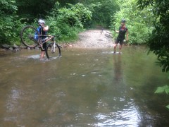
The upside of riding in that direction is you don't get your feet wet until the end of the ride. The downside is that it's only 2 miles to the car, but both of those miles are uphill.
I was tired, but the climb wasn't so bad.
What was bad though, was how filthy we were.
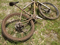
Like 90% of that came from 2 places: the sections of No-Tell and Jake that run along the old roads. Ten thousand puddles. Just awful.
"Fortunately" on the way home, we drove through some seriously torrential rain, with the lowest visibility I've ever seen, ever. Add to that, a tree was down across 285. It had torn through the highway barrier like it was made of paper. I said "fortunately" because the rain washed most of the bulk chunk dirt off of my bike. The drivetrain isn't spotless right now, but it's darn clean. It was funny though, only half of our bikes got clean. John has a hitch rack, and only the halves facing forward were exposed to the rain. My drive-side was facing forward. The other side is still pretty filthy.
Yeah, Bull Mountain! Ride there! Ride your bike. Ride your horse. Run. Walk. Walk your dog. Your time will be well spent. Spend your time well!


No comments:
Post a Comment