Yes! This is this hike I've been wanting to do!
I've been exploring the Upper Chattahoochee for a while now. It seems like if I give an area enough of a chance, it eventually pays off. My last two hikes have paid off, but today's did, especially.
I've always had fun riding up there, the gravel roads are some of the best in the state, if you're into gravel roads. But there's not a lot formally offered in the way of good hiking. The AT runs across the ridge, and there's a short jaunt to Horsetrough Falls, but that's about it. Officially, at least. There are plenty of old roads and trails, and I've been finding them, one by one, but it's been slow going, and I'd only consider hiking a few of them a second time.
Fortunately, I've been enjoying the woods, if not the trails. It's very scenic up there, I've seen plenty of wildlife, eaten wild edibles, waded in the creeks and rivers...
Last week, after searching for a trail all day, I finally stumbled onto it, but didn't have time to explore its upper reaches. That was item one on my list today: "the upper reaches." To that end, I drove up to Helen, parked exactly where I had last week and started walking up FS44B.
The bears have been busy up there, it would seem. There were tracks all over the road. Dozens of them.
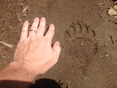
I guess they use the roads too. Must be easier than pushing through the woods. It occurred to me that I ought to get my camera ready, in case I see a bear on the road. As fate would have it, around the very next bend, I startled some deer, a mother and fawn. The mother snorted, spun, and bounded across the road, down into the brush, and the fawn followed, though not nearly as quickly.
I don't know where I learned this, but I learned somewhere that a fawn usually hides while its mother takes off to draw the predator away. I saw the direction they both went, and the grass along the road was really tall, so I thought I might see the fawn hiding there if I looked carefully.
I didn't have to look that carefully though, it hadn't even completely made it off of the road.
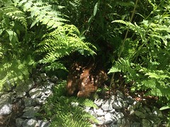
"You can't see me. If I'm still, you can't see me."
I almost didn't. I walked within inches of it. I had to take a step back to take the photo. I could have picked it up and walked off with it. Not sure what the law says about that though, and, of course, I might have been attacked by its mother. I used to have rules for the kids, in the woods... "Stay together as a group. Leave nature where you found it." That second rule came to mind too.
It occurred to me that I could touch it if I wanted, but about that time it also occurred to me that I represented pure terror. Paralyzing terror. The unknown, alien thing. No way I'd want "the unknown, alien thing" touching me. A photo would be good enough. Fortunately my camera was out and ready.
Yeah! Day's starting off right. Never been that close to a baby deer before.
Lets see how the rest goes.
My destination lay immediately ahead of me. I gently picked my way though the thorns and deadfall and the rockslide, and managed to get on the trail with less trouble than it took me to get off of it last time.
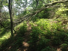
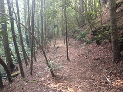
Yes. The Old Trail Ridge Road. That's what I'm calling it. If it has another name, somebody let me know.
That photo is more or less representative. Old road. Little bit brushy. Clearly defined trail. Trees down here and there. Lots of rocks, sticks and branches. Overgrown sometimes, but never for long. Shallow grade too, for the most part. It was easy to moderate going. I checked out a few side trails while I was at, and kept an eye out for more.
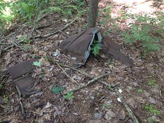
While doing this, an out-of-place-looking black monolith caught my attention, down below.
Turned out it was an old battery.
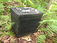
It was just sitting there. Not the trail I was on, but on a little spur of an older, intersecting, logging network. "Atlas. Farm Tractor. For heavy rugged service." It was neatly placed on the side of the trail, like it died, someone changed it, and left the dead one behind. It didn't look like it was dumped from the road above. If it was, it had a very lucky roll.
There was more debris futher on.
Another cable.
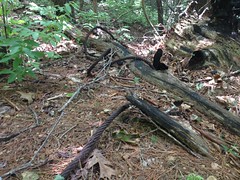
I must have found 20 of these over the years. This one was about 20 feet long. Probably the longest I've found.
There was sheet metal roofing too.
Clark says there's sheet metal roofing all through the forest. Tornadoes eat chicken houses and fling their rooves far and wide. Makes sense. That one's been there for a while.
The road ended abruptly and randomly, not far from where I'd gotten on it last week. When I say ended, I mean, it didn't look like it had been closed. It looked like the guy building it was like: "Ok, I'm done, right here". There was a small mound and the earth beyond looked undisturbed. About 20 feet further on though, there was another road coming down from above.
What the heck? I've seen this several times. Two old roads come within feet of intersecting, but don't. They would seem unrelated. It would seem whoever build the second didn't know of the first. There they are together, but their construction could have been separated by decades.
My old, hand drawn map shows a single trail leading all the way up Trail Ridge, to the AT. Either I wasn't on that trail, or maybe back in 1980 there was a more obvious little connector between the two. Not a road, but just where people walked through the woods between them. I've seen plenty of that too.
That other road led down to Jasus Creek. If it continued along the creek, I couldn't discern it. I looked all around and saw dozens of candidates but nothing that could definitively be described as "the trail". In the other direction it led up to a familiar spot on 44B.
Along the trail there were more delicious blueberries.
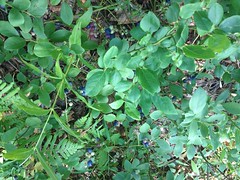
A feast of blueberries. I ate so many. SO MANY. Seriously, wild blueberries are like 10 times better than store bought. They have a ton of flavor, and they're tart.
There was some other red-violet berry growing up there too, but I didn't know what it was so I didn't eat it. In retrospect, I should have taken a photo of it so I could find out. Hmmm. Good thinking there Dave.
Well, mystery solved. Now I know where all that goes. Still don't know what the whole "trail all the way up to the AT" is, but I have a hunch. Maybe I'll follow up on it some day. Maybe.
The walk back to the car was long and semi painful. Gravel plus barefoot shoes equals feet feeling every piece of gravel. It's not terrible, but it's noticeable, and my feet are actually tired right now from it.
There were a bunch of trees down.
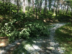
I guess that torrential storm that John and I drove through yesterday hit that ridge too.
Ok, so mission one accomplished. Pretty much.
Mission two...
"Do you know what LIDAR is?"
"I know what gaydar is. Is it like that, for lying? Like a lie detector?"
That is seriously, the conversation Kathryn and I had when I was telling her what I was going to do this weekend. She was joking, of course, but she didn't know what LIDAR is. Come to think of it, neither did I. Or, at least, exactly what it is. That wasn't the point though. The point was...
I've heard, perhaps erroneously, but I've heard, that the shaded reliefs used to make some topo maps look 3-D is based on LIDAR data. The computer places a fake sun at 2PM or so, in the summer, and what would be illuminated is lightened, and what would be shaded is shaded, more or less depending on how steep it is. "How steep it is" is based on LIDAR data that was collected by flying a plane over and scanning the ground with a laser, or something like that.
Whether it's actually LIDAR data or not, the data for the Upper Chattahoochee is quite precise. You can make out all kinds of features: modern roads, old roadbeds, even the bench cut of the AT, which, by the way, appears to vary significantly from the USFS GIS data. Oddly, it's less detailed for other areas of North Georgia, but it's very detailed for the Upper Hooch.
Looking at my own GPS data on top of it last week, I could see where a few trails went that I'd marked, but hadn't yet explored. One, I'd figured ought to be there, but could never find in real life.
My theory went... FS44 is the main loop up there. Except for an initial run along the Chattahoochee, its construction is very modern; very environmentally conscious. Bench cut, 50 foot stream buffers, concrete bridges, rolling dips, grade reversals... In the early 1900s though, Byrd-Matthews ran trains up in there to get the timber out. They needed shallow, consistent grades, and the concept of being environmentally conscious hadn't been invented yet. Or, if it had, they wouldn't have cared, they were intentionally removing "the environment." They'd have gotten in and out the most direct way. There ought to be old railbeds inside the loop. If I were them, and I wanted to log a vast, uncharted wilderness, I might start by heading directly up the river coming out of it. That's actually what 44 does, at first. Somewhere around where it starts looking modern, there ought to be something breaking off that looks much older.
My other theory was that there's no way serious fishermen were going to settle for fishing the Chattahoochee from the road. Too much pressure. There ought to be access to every single pool in the river. Given how long the river is, I'd expect a trail along it, even if it's just a really long scramble.
I'd looked for such a thing several times, with no luck. Every trail ended before the river except one which just crossed it. None were good candidates for a rail-based logging system.
But! Thanks to LIDAR, or whatever, I had a lead. There was something on the map. In retrospect, it made perfect sense that an old railbed would diverge, right there, for a number of reasons. It might be clear. It might be garbage. But, I had a lead. I knew where to look.
I drove over, parked and looked around. The map said there was something there. The brush was dense though. An old steam train could be parked down in there. I'd never have see it. Climbing down into the one spot where it was possible though, I found the old bench cut. Describing it as impassible is laughably inadequate, but that's what it was.
Hmm. Lets try again, up the road a bit.
Ha! Yep. There it was. Like so many things, once you know about them, they're so darn obvious. Without the lead, I wonder how long it would have taken me to find it. I'm sure I'd have come around eventually. Might have been years from now though.
At any rate, after about a dozen downed trees, the trail was free and clear and beautiful.
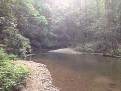
There were deep pools in the Chattahoochee, begging me to swim, but the trail really had my attention. Maybe next time.
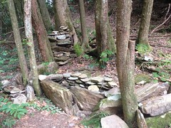
There were a number of campsites too. This one featured some interesting rock arrangements.
The trail crossed the river several times.
Always interesting. A little sketchy too.
I'm not sure, but it seemed maybe the goal was to be on the opposite side at each confluence. They achieved that, whether on purpose or accident.
The trail reminded me a lot of Raven Cliffs, but a bit less maintained.
Definitely an old rail bed though. Narrow, shallow grade, filled, cut, blasted out of the rock, at times.
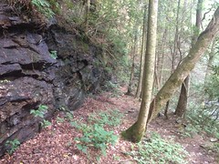
After the second crossing, it seemed to get less traffic, and it reminded me of Linville Gorge.
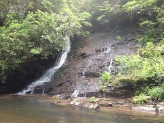
The confluence with Indian Camp Creek was a waterfall.
At Low Gap Creek, there was this fairly elaborate sign, bolted to a tree.
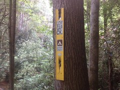
That's the clearest signage I've ever seen, on any trail, anywhere in the forest. And there it was, on an uninventoried trail, marking the location of another uninventoried trail. I wonder if those trails were actually part of the system way back, but at some point, just taken off the books to keep the word a little hushed, and the traffic down. If so, it's been pretty effective. I've been riding and hiking up there for 15 years and I just found it today, despite figuring it must be there, and specifically looking for it.
And yet, from the level of traffic it seems to get, and the look of the campsites, it wouldn't seem to be too big of a secret. Maybe if you camp and fish, you run into to it naturally, but if you ride or hike, you're looking for different things, and it consistently flies below your radar. I guess I just needed to have thought like a different kind of forest user.
It was getting late and I needed to get out of the woods so I made a loop rather than see how far the trail along the Chattahoochee went. It looks like it ought to keep going for a long, long time. Like 4 times longer than the section I already hiked. I think I know where it will end. I think I've been there before. But, we'll see. Maybe I missed something last time.
So, yeah, great day, all around. Marked by diversity of experience. ...which I give more points for than miles of trail.
I guess persistence pays off. And also, maybe, research.
I'm anxious to see what lies ahead.


No comments:
Post a Comment