When did this happen? 1 month ago? "I remember it as though it were a meal ago..."
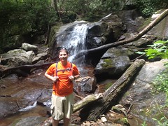
Billy called me up one Thursday evening, said he'd be in town that weekend, and wondered if I wanted to do some hiking with him. Of course I did! When he indicated that he had no particular destination in mind, I indicated the opposite, and though he didn't know it at the time, he might have preferred to have chosen himself. Billy is no fan of the slithery type, and as it turned out, where we were headed, they lay in wait, in abundance.
The family and I had recently Adventured the Chestatee WMA, in the general lower Blood Mountain Creek vicinity. On that day, we'd gone for a swim at Dick's Creek Falls, before exploring the general lower Blood Mountain Creek area.
I figured Billy might dig the falls, so we parked nearby and took a quick side trip down to it.
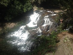
Of course, being appropriately dressed for it, I jumped off of the cliff of death and swam around in the pool for a while.
Billy wasn't interested in such shenanigans, and so we moved on quickly.
When the family and I had last been up that way, we declined the trail along Blood Mountain Creek itself because Kathryn isn't a big fan of treacherous scrambles. The girls and I however, had explored the trail years prior, and the waterfalls there were pretty amazing. I figured Billy would enjoy them, so we walked up the road a ways, and began the real hike there, near the confluence with Dick's Creek.
The "trail" that leads up along Blood Mountain Creek can barely be called that. "Scramble" is the word I prefer. I think the girls were 6 and 8 when we hiked it, and at the time I had good confidence in their ability to manage it, but looking at it again that day, I wasn't sure exactly how I had. It wasn't a problem for grown men, but it didn't exactly shout "bring your kids".
We managed it though, and the falls were just as I remembered them.
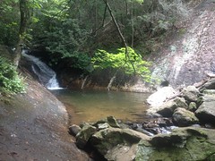
There are actually 4 cascades. The fourth is tough to get a photo of without spending more time than I wanted to. It was still early, but we had a long way to go, and I didn't want to dally about.
Above the last cascade, the trail kind of peters out. If you know what you're looking for, you can see where people usually go, where they get down to the creek, and where they usually cross. If you don't, you might just turn around, which is what it looked like most people did.
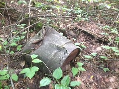
We found this weird cast-iron something-or-other up there.
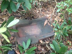
There are meadows upstream, presumably once part of a farm or settlement of some kind. And logging was rampant in the area in the early 1900's. I imagined it was somehow associated with farming or logging, but I couldn't identify it, and its location was enigmatic. It was across the creek and up a hill from the nearest old road, so it wasn't likely dumped. It seemed too high up off of the creek to have been washed downstream. Part of an old still? Seemed unlikely. No idea.
We bushwhacked a bit to the nearest road and proceeded north. Along that road we found a far less enigmatic artifact.
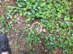
And confirmed my suspicion that the roads and trails my family and I had hiked the last time get a bit of horse traffic.
The northern-most meadow framed Blood Mountain nicely.

I had failed to get a photo of it the previous time, so I made sure to that time.
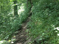
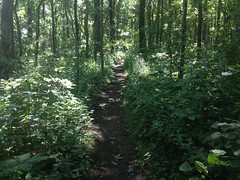
USGS Quads showed two trails in the vicinity, one of which led, allegedly, directly up along Blood Mountain Creek. The other led up some other creek that I don't remember the name of. We followed the first. It followed an old roadbed, and it was open and clear.
Across the creek to the right I spied the frame of an old shelter.
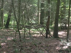
I've seen quite a few of those in the past few years.
I'd forgotten to fill my camelback at home, and it was getting a little low, so when the trail got close to the creek I took the opportunity to fill it up there.
Little did I know that the trail would get much, much closer later.
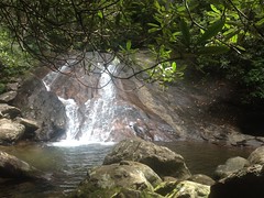
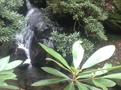
Before long it stopped at the foot of a small waterfall.
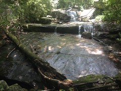
Samuel Thomas Yoder falls, I presumed.

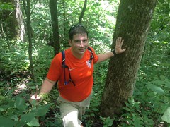
I tried to capture the scale by getting Billy to stand in front of it, but it didn't really work. The falls looks bigger than this in real life.
The old road stopped dead at the base of the falls. We scrambled up over it though, and, unexpectedly, found another old road directly above it. It started as abruptly as the other one had stopped. They were even aimed at each other. If they were connected at some point, then the bridge involved must have been quite a sight. I guess it's possible that the road was really an old railbed and a trestle climbed the falls. It didn't strike me as a rail though. Really, none of the roads in the area did.
We followed the newly discovered road up and up. We were clearly not the only ones who had ever gone that way, but it was definitely the road less traveled. Eventually, it joined another old road, which led off in both directions, and appeared equally well traveled in both. I wondered if we'd missed a spur lower down. We certainly hadn't been climbing long enough to reach the end of the trail, as shown on the map. When in doubt, keep climbing.
We did.
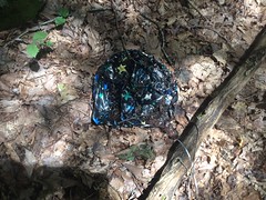
There was an old iron drum up there somewhere.
And, of course, a balloon.
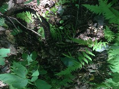
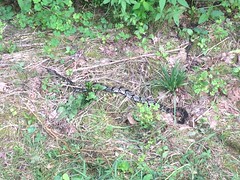
And we ran across a dead snake with no head at all.
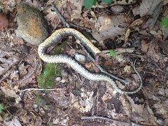
I couldn't immediately identify it. Northern water snake? Banded water snake? Midland brown? It didn't strike me as any of these, and I'm still not sure.
But I was sure of this one!
Timber rattler!
Billy is terrified of snakes. He didn't mind the dead one, but he really didn't like this one. I had stepped directly over it without seeing it. It made me wonder how often that happens. We had been discussing snakes on the way up. Rattlers are dangerous, but they've always been rather docile in my experience, the one exception being the one I ran into on Tibbs, which was super pissed after John and Marc Hirsch nearly ran it over. This one was no exception, and I pointed it out to Billy.
He was having none of it though. The old roadbed was probably 12 feet wide, and the snake was all the way to the inside, but rather than just giving it about 9 feet of room, Billy walked down the slope under the trail and probably didn't come within 30 feet of it.
"There might be ANOTHER snake down there Billy!"
"Yeah, well, I know THAT one isn't down here!"
Ha! Good point, I guess.
According to the map, the old road should eventually tee into another old road, way up Blood Mountain, but lower down than the Freeman trail.
At a point, it was clear that the map was wrong. The trail kept going and going, and then it just ended abruptly. From a later look at the Lidar data of the area, it looks like it may have made a hard left across the stream, but there may have been a bridge involved at one point. Standing there, it wasn't clear. It looked like the very end.
We stopped there, sat down on some logs, and had a bite to eat. Bugs annoyed us persistently, but none of them bit. They just buzzed around incessantly. Actually, I did find a tick crawling on my ankle, but it wasn't biting me yet.
It was possible that the road we'd expected to tee into was still further uphill, or it was possible that it just didn't exist. I wasn't sure, but I was sure that the Freeman Trail was uphill, and we'd hit it eventually if we kept climbing.
And that, we did, not 100 more yards uphill.
The Freeman Trail led to the AT.
Which led to Jarrard Gap.
Jarrard Gap road was the road that we were supposed to have intersected earlier. I was really curious why we hadn't, so we followed it as far as we could.
Turned out that wasn't very far though. It becomes a private drive after a half mile or so.
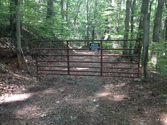
That's a fairly unusual sight: an inholding, completely surrounded by Wilderness.
When we'd been at Jarrard Gap earlier, I'd done a little scouting run down a trail leading east. Later scrutiny of the same Lidar data that I mentioned before revealed that this trail would eventually become the old road shown on the map. Someone had apparently gotten it confused with Jarrard Gap Road way back.
Well, with that mystery solved, we had to decide how to get home. We'd seen a spur to the right a little ways back, which seemed to correspond to a line on the map. If it did, indeed, then it would eventually drop us onto FS34.
And that's exactly what it did.
There was supposed to be another spur leading off of it down around Dicks Creek, but the only spur we saw down there was older than the trail we were on, and much more overgrown, so we stayed on the most well-traveled path.
At FS34, we met a man and his wife hanging out on the tailgate of their truck, just enjoying being in the woods. The man was packing heat, so I was a little apprehensive about approaching them, but they were parked in the direction we wanted to go, and I really wanted to go that way. They were quite friendly, actually. I guess the heat wasn't meant for me. They had all kinds of questions for us. They'd seen where we'd come from and wanted to know what was up that way, specifically if you could get to the AT without too much trouble. There are actually 4 different directions you can go from that point. I'd been down two of them already, so I gave him the rundown. They had only explored a bit of one of the roads we'd been on earlier. They'd found the same trail along Blood Mountain Creek but hadn't followed it for any real distance.
We chatted them up for a while, but eventually had to keep moving. The trail we were interested in was another old road. When it ended, a rough trail continued, but even that petered out eventually and we found ourselves whacking down to Blood Mountain Creek, and then back up to the road we found that horseshoe on earlier. From there we headed south through several meadows, including the one that Kathryn and the kids and I had seen the bear in earlier this year.
There were no bear that day, but there was another Timber Rattler.
And Billy wasn't any happier about that one than he had been about the last.
I guess 3 snakes (one dead) doesn't really count as the "abundance" I mentioned earlier, but Billy isn't interested in running into any number of snakes greater than 0, so I'm sure in his mind, "abundance" seemed like the right word to use.
I saw 2 coyotes too, but they bolted before I could get a photo. Their coloration was amazing though. Some of their fur was almost blue.
We eventually took the old road down Crow Mountain, back to FS34, and that back to the car.
Actually, I went for another swim below the falls before we went. It was in the mid 90's and the water felt really good after the long day. The only trouble was that my body felt extra heavy after relaxing in the pool for so long, and the short trip back to the car from the falls felt a lot longer than it was.
In total, I think we walked about 15 miles, on every type of trail imaginable, and even some cross-country. We saw every kind of think I usually set out to see: woods, waterfalls, wildlife, and artifacts. I jumped off of a cliff, and swam in a river. It had been a long, fulfilling day, and wee were both pretty exhausted on the drive home. We may have grabbed some Zaxby's in Dawsonville, but I have no specific memory of it.
Yeahhh, Blood Mountain Wilderness! Great fun. And, there's still a good bit of it that I hadn't seen yet, so I was sure to be back soon.


Sam yoder was my best friend.
ReplyDelete