I'd felt good last Sunday and Monday, but then Tuesday and Wednesday I felt pretty terrible again, like maybe I'd gotten a secondary infection. Thursday I had energy, and it seemed like some fresh air would do me some good, just as it had the previous Sunday.
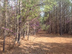
To that end, I reprised Sunday's festivities with further exploration of the Friendship Church area of the Paulding Forest.
This time I parked up the road from the church, at the other end of the loop, and hiked some "trails" on that side.
I say "trails" because most of them were much more like unmaintained roads than proper trails.
But fresh air is fresh air, and I was happy just to be well enough to be outdoors at all.
I have no idea what the actual road I was on is called, but I call it the "Friendship Baptist Church Area Road" on my maps. Somewhere out there, a ways down that road, Inland Rome has an inholding. It's surrounded by the Paulding forest, but I guess that little square of land belongs to Inland.
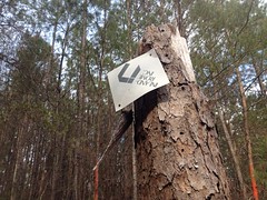
The borders were fairly well marked, with orange paint, but there were no keep out or no-trespassing signs, and the road went right through their land, uninterrupted. Temple-Inland has a reputation for being friendly to outdoor types. They sponsored a mountain bike team for a while. I also remember while scouting the area north of Rome for the TNGA, I kept running into Inland tree farms, but I met a guy on an ATV who alleged that he ridden the trails through the tree farms for 15+ years, encountered Inland staff plenty of times, and "nobody cared". I ultimately decided not to run the route through the tree farms, but it seemed like I probably could have gotten permission to, if I'd tried.
As such, I figured it was cool to pass through, just not to hunt there. Turned out it was a fairly small chunk of land too. Couldn't have been 1/4 of a mile long even.
On a little side trail, I found a DNR trail cam securely fastened to a tree.
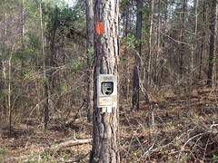
I bet they've got a photo of me taking a photo of them now.
I had a time budget, and I really wanted to get down to the Cochran Branch and Raccoon Creek area, so I didn't get to explore every trail in that direction, but I got the general gist of it.
It's barely spring, but some grass is starting to grow, and some trees are trying to leaf, especially down along the creeks.
The trees are super confused though. Usually redbud blooms first, then pear, then cherry, then dogwood. I'm always praying for dogwood because I'm allergic to cherry (or something else that blooms at the same time), but this year cherry bloomed in early February, then stopped. Then pear bloomed like a week later, and now redbud, cherry (again), and dogwood are all blooming at the same time. I saw all 3 driving in, and the woods was full of redbud and dogwood.
Ha!
I figured I'd take an off-trail shortcut down to Cochran Branch, but I ended up on an old abandoned road that went right where I was planning on going. What luck!
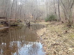
The shortcut probably saved me 15 minutes, and before I knew it, I was at the furthest extent of the old road that I'd yet explored, right where it crosses Cochran Branch.
This time, I crossed the creek and followed the road around and up over the hill on the other side.
There was a ton of river cane growing on the south side of the hill.
Some of it was 20+ feet tall and as big around as bamboo. I've seen thickets of it before, but none as dense and tall as that one.
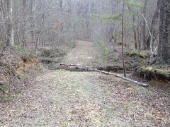
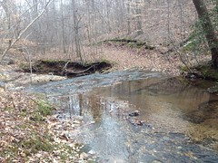
The road dropped down to Raccoon Creek...
...and eventually forded it.
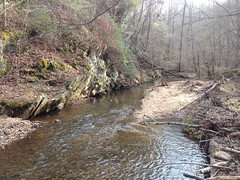
On the other side, I found a little side trail leading to a deep pool with a nice little beach.
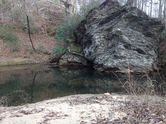
The pool looked deep enough to dive into, or at least to cannonball into. I saw some little trout in the pool too. I may be back this summer for a bit of both.
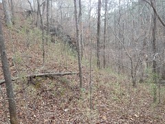
The old road led up and along the ridge of another little mountain, and eventually deposited me at the active rail that crosses that part of forest.
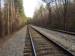
I say "the active rail" because the Silver Comet Trail crosses the forest too, and though it was once an active rail, it is now, of course, a bike trail.
There were lots of little side trails that I didn't have time to explore, so I guess I'll have to make a trip back some time to check them out. I followed what seemed to be "straight ahead" at each little intersection, but apparently, one of the little side trails, way out toward the end was "the right way" to go, and the way that seemed like the main route was actually a side trail, or at least it diverged from the dotted line on modern topo maps. It was funny too, because I was studying the map rather carefully and the route I took seemed to match up pretty well.
Hmm... Gonna have to work on that, I guess.
On the way back, I noticed another trail cam, which I'd apparently walked right by without seeing on the way out.
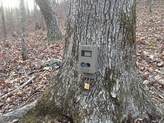
I didn't notice at the time, but when I compared photos, I noticed that both cameras have the same number on them: 7102. It makes sense to number the cameras with a unique identifier. "Bill, go check cameras 7102, 7103, and 7104." "Saw lots of hog activity on camera 7102 last week." "Who's this goofball in the black tights. We caught him on cameras 7102, 7103 and 7104 last week." And so on... But why would 2 cameras have the same number? Seems like it defeats the purpose. I guess the number is not intended to be a unique ID for the camera. But, if it's not, what does it mean?
Weird.
About halfway back, I saw a turkey running down the road. I'd seen tracks all day, but no actual turkey until then. I'd seen a chipmunk earlier too. Yay, wildlife!
I'd left a note for Sophie before I left, telling her I'd be back for 7:30, and I'd been checking the time on my GPS all day. At about 6:30, I was about 5 minutes from the car, and I was thinking to myself something like: "All right Dave, you made really good time today, and left yourself an hour to get home, even though you only need like 45 minutes. Great job!" But right as I was thinking that, I got this wave of panic like something wasn't right. Maybe the angle of the sun didn't sit right in my subconscious, or something, but whatever had occurred in the back of my mind, it eventually made its way forward as doubt about the time of day. I checked the GPS again. 6:30. I checked my phone though, too, just to be sure. 7:30. Christ. My GPS predates the 2006 changes and it hasn't "sprung forward" yet. Dangit!
So, rather than being super on top of things, I was an hour late.
Nice job loser.
I called Sophie though, and it was OK. There was plenty of chicken in the fridge and she was happy to heat it up herself. So, no crisis, but man, I hate when that kind of thing happens.


No comments:
Post a Comment