Some time ago now, back in early January, I got the urge to explore a bit up in Bartow County. My nephew Austin had, some time earlier, posted a ride on Strava that he and some friends had done up there, He'd somehow managed to ride some stuff that I had never ridden, despite me having made an actual effort to "ride everything" for the past 20+ years. Goodness! This would never do. I was determined to check it out, but a few months ended up passing before I was able.
It looks like it was January 7th when I finally made it up there, which was actually good, because if you want to be able to see stuff off in the woods, away from the trail, it's best to do that in the winter. That will be important later...
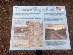
I parked at the Allatoona Pass Battlefield Lot,and just in and around the lot itself, there were all kinds of interesting things to see.
There were various historical markers and signs...


The house across the street was apparently an old plantation house, from that era - the John Clayton House, now Mooney House.
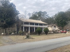
You can actually see it in one of the photos on one of those historical markers.
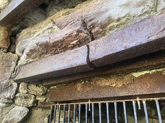
The most interesting thing to me though, was a "Sherman's Necktie" just lying about, nearby.

I din't think there was anything indicating what it was, but when I saw it, I recognized it immediately, just from descriptions I'd read online. I never thought I'd actually see on in real life. I figured they'd all have long been scrapped by now. When Sherman marched through Georgia, waging Total War, one of the things his soldiers did was tear up railroad tracks and twist them into contorted shapes like this. Prior to Sherman, it was common practice to tear up tracks and bend them, but it tured out that bent rails could be straightened, on site, and put back down. A twisted rail had to be melted down and reformed - much more labor and time consuming. Of course it was also labor and time consuming to twist them, but it was apparently worth it.
I still can't believe these still exist. I'll be upset if I find out someday that this one is a replica or something.
The trail that I was out there to ride was the Allatoona Pass Trail. Historically, the railroad led through "Allatoona Pass" before crossing the Etowah, and then continuing north from there. These days, it's been rerouted to the west a bit, but you can see on old maps where it used to be. The trail follows the old railbed through Allatoona Pass.
This is Allatoona Pass proper.

I can't seem to find info on this anywhere now, but I believe, at the time, at least, it was the deepest hand-cut ever made. I'm not sure if it still is, but I believe that it at least, was.
As I headed west along the trail, I passed a bunch of side trails and features. You can't ride a bike on the side trails, and I don't think you'd really want to if you could, so I'll have to come back on foot, someday, to check them out.
There were various entrenchments...

...a marker for the Grave of the Unknown Hero...

(I later tried to find the actual monument, but couldn't)
...and a tree eating a sign.
(always fun)
Once you get through the pass itself, the trail is like any other gravely rail-trail.
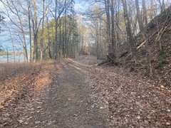
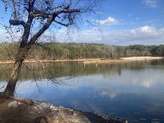
You do get nice views of Allatoona Lake here and there though.
At the very end, it tees into a gravel road. On the other side, you can see where it once continued on, but has since been filled.

I think a road crosses over the top of that fill.
I explored up and down the road a bit, only to find a bunch of private property, before heading south back to pavement. Just before the pavement though, I rounded a gate, with a bunch of private property signs on it. Was the road itself private? Odd that it wasn't marked where the trail teed into it. Also odd that drives off of it were also marked private. IDK. Sometimes I see this... The road itself isn't per-se private, but everything back there is, so the road gets marked private too. Or, the road is private, but there's a variance or agreement in place to allow legitimate traffic to anything back there (eg. Hills Lake Road).
Who knows?
Back on pavement, I headed west toward Hwy 41.
I needed to make a pit stop though, so I took a quick trip through the QuikTrip...

...which was, conveniently, on the way.
Getting up onto 41 was kind of tricky. I remembered having trouble doing it while driving, but had forgotten the details. As I'm writing this, it's been a while, so I don't 100% remember the issue now either, but I want to say that you can only get on going towards Atlanta, or maybe you can't get on at all, only off? I don't remember exactly, but I ended up either riding up the shoulder of the exit, or up the shoulder of the ramp to go south, then crossing over, hopping the highway barrier, and scooting across to the other side of the northbound lane.
It felt like Adventure. I remember that.
I basically took the shoulder of Hwy 41 north, crossed the Etowah, and took the next exit, which led me back down to the Etowah.
There, I got a good look at the old pilings that once supported the train trestle. The train would have come north through the pass, then over the river here.

From there, I headed east towards Lake Allatoona.
Almost immediately, I passed the New Riverside Ochre Plant.

I want to say that it's the oldest, continuously operating business in Bartow County, or something. IDK, maybe whatever it is is less impressive than that, but it has some historical significance.
Just up the road from that lay the ruins of the Blue Ridge Mining Company's manganese milling plant.

The ruins are interesting, but I've explored them before, so I just stopped for a second to take a quick photo.
Further west lay the Cooper's Furnace Day Use Area. In warmer months, you can drive right up and park in their huge lot, but this time of year, the gate is locked and there's a sign that says "Don't block gate", but you can't usually see it because of everyone parked right there, up against the gate, blocking it.
The Cooper's Furnace Day Use area is, appropriately, named after Cooper's Furnace, which lies just north of the road, a ways inside the park. Me and Billy hiked all over this place a few years back, at about this same time of year, so I'd seen the furnace before, but it was still pretty cool to see again, and this time I got a bunch of good pictures.


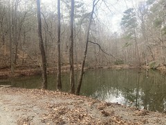
There's a gravel road leading north up into the woods near the furnace. It's mellow at first, but then you hang a right near this pond...
...and it really kicks up from there. On the way up, I passed a guy and his wife, and the guy seemed really impressed that I could even climb it on a bike.
Near the top, I passed a couple, out hiking, who had various questions about where they were, and where everything else was. They didn't immediately strike me as lost, but I kept them in mind as I rode on.
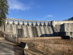
At the top, I hung a right, and rode out to this overlook-park-thing, where you can see the dam from above.

Pretty awesome!
As I came back down, I kept an eye out for that couple, and eventually saw them heading for their car in the upper lot. It appeared that they were, in fact, not lost, which was a bit of a relief.
Heading north along the road, I passed a "Christmas Tree Drop-Off", which I'd never seen before.

Apparently, you can ditch your old Christmas tree there and somebody will pick it up.
Nice!
The Pine Mountain Trail was north of that, and I could tell I was getting close by all of the cars parked along the road.

Popular place, I guess!
The lot itself, was actually fairly small.

There are only 2 trails open to bikes, and only on Wednesday and Saturday, and it's directional, depending on the day.

The last time Billy and I were up there, hiking, we had run into some mountain bikers that explained this to us. Since then, I've wanted to get back up and check it out, but never really felt the urge until learning that Austin had ridden up here.
The Pocketknife trail was steep and technical, and definitely not designed with mountain biking in mind.
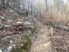
It would have been moderately challenging just to hike.
That said, it was super popular. I ran into dozens of hikers coming down as I headed up, all of whom seemed to be having a good time.
But, if I thought that the Pocketknife trail was challenging on a bike, it was only because I hadn't yet gotten to the Backpack Trail.
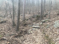
This photo doesn't do it justice, especially with nothing for scale.
It's a bunch of super-technical stair-step switchbacks, all the way down. I actually wondered if I had somehow gotten on to some hike-only trail, stopped, and checked the map, to be sure that I hadn't. No, I hadn't, and I eventually started seeing signs saying that it was, in fact, the backpack trail.
It was a lot of fun to ride, but it demanded all of the rock-crawling skills that I had.
It was so technical, that it made me wonder if maybe that wasn't what most people rode up there. I had earlier seen 2 side trails - one that led up to the peak, and the other, I'm not sure where it went. I wondered if people took those trails to somewhere else. The trails on the west side are closed to bikes, and the map made it look like the trail up to the peak was too, but later when I looked on some online map site, it showed the trail up to the peak as open to bikes. Hmm...
On the last 100 yards or so of the trail, I ran into another mountain biker who confirmed that there are other trails out there that people ride. I'd have to come back and explore some more, in the future.
At the time, though, I had other things to see, so I headed back towards the dam, making quick side trips through the picnic areas to the north, along the way, which gave me some nice views of the lake.

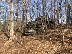
There is also a lot of cool-looking exposed rock back in there.
All that done, I bombed back down that gravel road to the furnace, and milled around the lot for a while.
This was a little creepy...

Someone had left a bike just lying there, abandoned. Nice bike, too. At first, I figured they may have just dropped it to run off and pee, and maybe they had, but it seemed like an odd location for that. The top-tube bag was empty and still open. I tend to lean my bike against something, or lay it down carefully when I get off to go run around. I usually leave it in an inconspicuous place too. The more I looked at it, the less it looked like any of that. Maybe someone stole it, couldn't effectiely ride it with the pedals, rifled the top-tube bag, then left it there? No idea. The more I looked at it though, the less good I felt about it. But, honestly, who knows? The owner could have been off doing who-knows-what, and just needed all of whatever was in the top-tube-bag to do it. I've certainly done similar, figuring my bike was safe wherever I left it because of the obscurity of the location. Could be a similar situation.
I got a good look at the Allatoona Dam from below, while I was running around back in there too.
But, I still had one more destination in mind, so I didn't spend too much time in the lot.
Legend has it that the Bartow Lumber Company had a factory somewhere up in Hurricane Hollow, and that there were 20 or so homes up in there while it was in operation. It was apparently closed in the early 1900's, and everything has since become overgrown ruins. I'd seen photos of some of the ruins, but never seen any of it in real life.
It looked like there was a bit of a trail leading up into the hollow, so I followed that. Eventually it became clear that the trail was an old roadbed. It didn't appear to get a lot of traffic, but it wasn't overgrown, and I could make out footprints and even tire tracks, so somebody uses it, here and there, at least.
I kept an eye out for ruins, and lot too far back in there, I noticed some off to the left.
Kind-of way off to the left though. If the trees had been leafed-out, I don't think I'd have seen them.
I had to cross the creek and a good bit of flat ground to get to them, and there were a bunch of thorns right up near the creek, but it was worth it. The ruins were extensive.


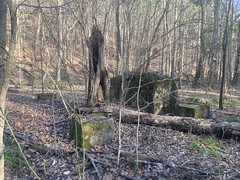
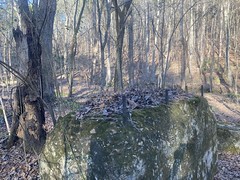

Man, so many footings and mounts for machinery. I'd be pretty surprised if those ruins weren't the core of the factory.
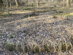
Further upstream there were some interesting rock formations, with little caves in them.

Further up from that, the road diverged from the creek and started climbing the mountain. there was also this enigmatic "32" marker on a tree nearby.

I didn't feel like climbing back up the mountain, or exploring what already looked like a maze of overgrown side trails. That would much more easily be done on foot, so I figured I'd come back for that.
Instead, I headed out, back towards the car.
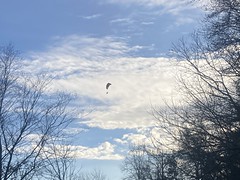
On the way back, along the Etowah, I noticed a guy in a paraglider, flying overhead.
I also noticed humourous graffiti on some old building.

Tossed Salad Gang, eh?
It was easier heading back on 41 than it had been heading out. No need to hop guardrails, for instance.
When I got back to the lot itself, I had more energy than I expected, so I rode around locally for a bit.
As luck would have it, a train came through, right as I got to the crossing, but my sweaty fingers couldn't get my sweaty phone to work quickly enough to catch the engines.

It looked like the old railbed used to cross this dam, so I followed that for a bit.

Nice view of the lake from the dam...

At the far end of the dam, near where I had first gone into the woods, ther was "The Memorial Field", which I hadn't seen earlier.

There were elaborate memorials to soldiers from all of the different states that had fought there.


It's always strange to me that battlefields and other historical places end up being turned into recreation areas. I had a good time riding my bike all day, but people fought and died here. It's similar in Pinelog. I have a great time riding my bike there, and exploring the ruins... of the prison labor mine where people were regularly worked to death for decades.
I'm not sure there's anything better that can be done, but what we do is definitely strange.
Ok, that's enough, time to go home.
It had been a while since my last haircut, and I had quite a case of helmet hair.

Heh.
I ended up running by the gas station on the other side of the road on the way out for snacks, and got this amazing Strawberry and Dark Chocolate Kit Kat.

I'd never had one before, and I highly recommend.
No idea what I did for dinner, and I don't remember the drive home, so it couldn't have been too eventful.
All-in-all, a pretty good day. I saw a lot of cool stuff, and also found lots of stuff that I need to explore in the future. Hopefully I'll be able to get back up there before it starts leafing out again. IDK though, I saw daffodils earlier this week.


No comments:
Post a Comment