On the drive up, it was 50 degrees and the rain kept flipping back and forth between downpour and a drizzle. It was always coming down, but I could always see blue sky somewhere too. No way to know whether it would be wet or dry, hot or cold. I'd been concerned about that before I left and packed every stitch of clothing I owned, just in case.
I parked just up Old Dial Road from Sandy Bottom. I'd seen a trail there before and the topo maps showed kind of a lasso too.
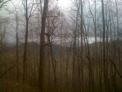
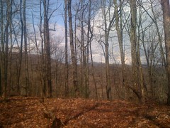
Part of the loop still existed, part had been rerouted, most of it was overgrown. There was a trail up through the middle of the loop too. It looked like people used it to get to the headwaters of the creek, but few ventured beyond that. On the south side, there was a pretty good view in the general direction of Blue Ridge.
Instead of finishing out the loop, I took a trail over towards Weeks Mountain and another one up the ridge. I figured I'd finish out the loop later on the return trip. Little did I know...
The Weeks Mountain Ridge Trail petered out quickly. On top, there were obvious signs that people walk around up there, but nothing I'd call a trail. There was an Ammo Box though.
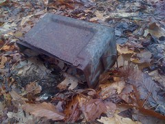
I've seen them all over near Camp Merrill. The Rangers use them as orienteering markers. Of course, they also use them to carry ammo. I wonder which this was. Geocachers use them as too, but this one looked like it's been sitting up here longer than geocaching has existed.
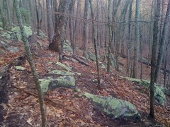
I followed the ridge toward Garland Mountain and picked up a trail down toward FS35. It looked like somebody had made a specific effort to reclaim the trail, but somebody else made a specific effort to keep a path hacked through it. Near the bottom, I spotted this enormous rock pile.
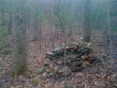
Too big to be a collapsed chimney, unless it was a really big chimney. Uphill, there were more of them.
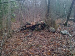
Some were sort of trying to dam a little trickle of a creek, others were just out on the hillside. They were clearly built, but why?
When I hit 35, I started jogging east. A guy in a red truck offered me a ride, but I was good. A few minutes later I passed his truck, parked off to the side. He wasn't dressed for hunting or fishing. I wonder what he was up to.
I wandered around on some side trails for a while but I didn't find anything all that interesting.
The rain had pretty much stopped and there was blue sky above me. For a while it was actually warm, but from time to time, out of nowhere, blam! and have to put my jacket back on, then as soon as I did that it would stop and it would get warm again.
One trail looked like it might lead up to South Brawley Ridge. On the way up, I found this gnarly skull of a young buck.
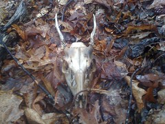
My wife sort of collects them. If I left this one here and she found out, she'd be pissed. I cut a chunk of cord, fed it through the eye sockets, wrapped it around a couple of times and tied it to various points on my camelback. In the midst of this operation, it began raining extremely hard, thundering, and sleeting. Huddled down though, as I was, with my jacket draped around me, I actually stayed pretty dry. It seemed like a good time for lunch and ate one of the bagels I'd brought with me.
The rain stopped and I got going again. The trail didn't quite lead up to the ridge, but somebody wanted it to and had marked a route with white and orange ribbons.
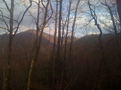
The view was nice.
I checked the time. It was getting late. I'd planned on heading down and taking a trail I'd seen before up to Ledford Gap. No time for that. Instead, I took a different trail, directly toward Ledford. When it ended, I aimed for a little gap to the west of there and sidehilled for a while.
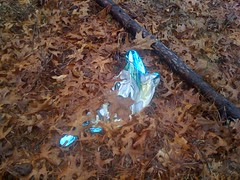
I have this theory that for every square mile of forest, there is at least one mylar balloon.
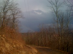
The woods got denser as I approached the gap, but I eventually picked up a trail that I'd been on before and took it out to FS45. The weather that had pounded me so hard before had moved on the east, leaving a rainbow behind, barely visible in this shot.
I jogged over to Ledford. I'm finally getting to where I can jog for a while without wearing out some odd little muscle. Not for miles at a time, but at least for miles a day. At Ledford, I looked around for an old roadbed. Some Low-res USGS maps show a road leading up from around Hurst, but the higher-res maps don't show it. Maybe it would be there, maybe it wouldn't. As luck would have it, it was, and right where the map said it would be. I didn't see any footprints, hoof prints or bike tire tracks, just the shallow impressions left by ATV's. I'm usually critical of ATV's, especially in a riparian zone, and they're certainly illegal in the National Forest, but they had tread lightly on this particular trail. There were a few short runs where it was below grade and there were a couple of reroutes, but nothing like Anderson Creek or some of the trails around Cashes Valley.
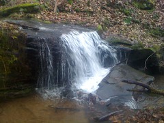
The scenery was beautiful.
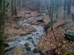
Near the creek, it might even have been old growth. I'll have to come back in the summer when I can tell what kind of trees they are. There were plenty of flatts. I wonder if there were settlements up here way back.
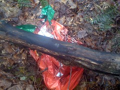
Down near the bottom, I ran across this old heap.
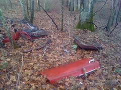
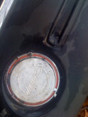
I wondered if I could identify it. This was a clue.

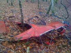
And this was a bigger clue. Probably a Dodge Charger, the only car I know of where the back glass is set into the body like that.
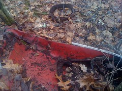
Yep, it's a Dodge Charger all right.
I love finding old junk in the woods. Not that I approve of dumping, but if somebody's already done it, it's neat to run across it 20 years later.
Another balloon.
The trail teed into FS82 right where I thought it would and I began climbing along Rocky Knob Ridge.
I'd seen a trail up there last time, heading toward Hickoryland. I'd hoped I could make my way on it, over to Persimmon Creek, up to the BMK and back down to the Sandy Bottom loop I was on at the beginning of the day.
Unfortunately, the trail ended just below a little gap on Hickoryland. I climbed up over the gap, set off on a course toward upper Persimmon Creek and immediately found another trail, which led to a vast, lichen-covered boulder field. This photo shows only a very small section of it. I've seen a lot of boulder fields, but this one, being green, was especially cool.
The trail led to a ridge and ended at an unimaginably overgrown logging road. It looked like it was pretty close to the trail I wanted to pick up on Persimmon Creek though, so I bushwhacked down through it, and voila, there it was. I needed to head southwest to get to the creek, but to verify that this was the correct trail, I needed to go northeast. I tried for a few hundred yards, but the trail was getting overgrown, the sky was getting dark and I really wanted to get to the creek while I could still see.
I turned out that I was on the trail I was looking for. It apparently heads upstream, bends around and tees back into itself. There are quite a few trails in the area that do that same thing. It's kind of weird. My first guess is that there were once farms here and these roads just led all around them. I guess they could just be logging roads, but they just don't have that kind of a feel to them. Maybe this was once a Horse or ATV trail system. Who knows?
At Persimmon Creek, it was officially dark. My original plan was out the window, but I had a new plan, and it should have been easy; find the feeder creek, follow it upstream to the Persimmon Creek trail, follow that out to FS119, 119 to Old Dial, Old Dial to the truck. I found the feeder. There was a big rock pile there, looked like a collapsed chimney, but it was too dark to get a photo of it. The map shows a trail right along the creek, and yeah, there is one, but it was choked with Rhododendron and in the dark, virtually impassible.
Nevertheless I pushed through it for what seemed like an eternity. It seemed like I should have gotten to the other trail by now. Did I pass it up somehow? If I just go uphill, I should hit the Persimmon Creek trail, but what if I pass it up too? What if I can't find my way back down to the creek? I felt like I did when I very first started learning to navigate off-trail. There are obvious answers to all of those questions, but none of them came to mind at the time. I have enough experience bumbling around in the daylight to be confident, but none of that confidence applied at night. Was it that easy to walk past the trail? Could I actually miss it? Had I gone far enough? Checking the map, I realized that all I needed to do was walk south and I'd eventually hit either the Persimmon Creek Trail or FS119. Duh. So, I did that. My brain kept wanting me to turn west, but I fought that urge, eventually got to the trail, and the jog back to the truck was uneventful. On the road, a truck passed me. I waved, they waved. It didn't seem odd to them that I was out on the road by myself in the dark :)
Looking at the GPS later, I just hadn't gone far enough upstream. I was about 100 yards from the intersection. If I'd been a little more persistent, I'd have gotten there. They say night-nav is hard. I could definitely use some practice.


please please tell me you pried off that charger logo'ed gas cap or whatever it was. neat stuff.
ReplyDeleteI almost did, but I left it, then later I thought "man I should have grabbed it." I'll get it next time I'm up there.
ReplyDelete