Having missed the Drama Queen, I woke up Sunday morning with a craving for some dirt and a destination already in mind. I'd snapped a stem bolt a few weeks back though and my front brake pads were completely worn out, so it took a few minutes to get out of the house.
It took a few minutes to get to my destination too, like about 130. My destination? Pigeon Mountain. So far I've only had a moderate amount of fun exploring up there, but I feel compelled to finish what I've started. You never know, maybe the next trail will be great.
I parked at Estelle Lot, which I'd seen on the way back to the car last time. It took me a minute to find the trail, but I did, and after a short jog up to the road, I was in familiar territory. And, then, soon after, back in unfamiliar territory - the Estelle Mine Trail.
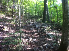
For the most part, it was rideable. The ground was strewn with debris, but the grade was shallow and consistent and I was moving right along. I did take a quick out-and-back on the Branch Trail, which intersected with West Brow and was much less ridable, at least uphill, but Estelle Mine itself was great.
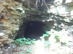
I'd been looking forward to riding this trail to solve a minor mystery. A long time ago I'd read that there were a series of tunnels along it. The tunnels were allegedly mines, but that never made sense because they were described as were short and open on both ends. I hadn't seen a tunnel yet though.
I did cross a series of dams, in odd places, and then went through a deep cut. Ohhh, wait! Those aren't dams, they're fills. The rusty gears in my head started turning. This is an old rail bed! The tunnels aren't mines, they're train tunnels. Hah!
Right about then, I saw the first tunnel. It was about 100 yards long and I could see all the way through it. The entrance was partially blocked though and I'd have had to crawl in, so I kept to the trail and went around that one. The second tunnel was slightly less blocked, but the third was wide open. I could have ridden straight through it.
Instead though, I followed the trail around to the other end...
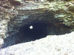
...and rode back through from that side.
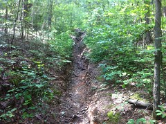
The ground was covered in big, chunky rock, but it was completely ridable.
There were a few more tunnels, including two that had completely collapsed.
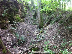
Instead of going through the tunnels, the trail followed an old roadbed up and around them. The road was extremely wide and deeply depressed. At first, I thought it had been run up a drainage, but eventually I realized that it had created the drainage. In some places it was really trenched out...
... but the trench was wide and I didn't have much trouble riding it.
I still don't totally understand the road leading up and around the tunnels though. Was it built to bring in equipment to then build the rail? Was the rail abandoned and replaced by trucks that used the road to get ore out? Was it not a road at all, but rather a series of strip mines, now connected by the trail? None of these possibilities seemed likely. It's a bit of a mystery.
There was no mystery about one thing though. The fork that I'd had rebuilt a few weeks back was working just right. The last time I was up there, it had beaten me to death. Today, I was enjoying the ride.
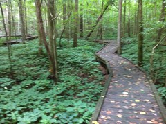
I rolled through the Pocket Road Lot toward the Wildflower Trail. I'd seen signs for it last time and it looked like it had a boardwalk or something. It turns out it's entirely a boardwalk, raised up over a wildflower area next to Pocket Creek.
No bikes were allowed on the trail, so I carried.
This is what I mean when I say "carried":
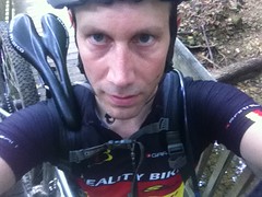
I hook the seat on my shoulder and hold the down tube near the bottom bracket with my right hand. Actually, I don't even need to hold the down tube, the bike pretty much just balances on my shoulder, but holding it takes some weight off.
I didn't see any wildflowers along the Wildflower trail, just endless tickweed.
About halfway around, I passed a lady and her daughter enjoying the view. Just past them, the boardwalk led to a trail up along the creek. I parked my bike and followed it. Some hikers were coming back the other way and I spoke to them for a minute. I asked if there were any pools up that way. They said no, but there's a big cut-out.
I didn't realize they meant that it was a waterfall!
No water was actually falling at the time though. Georgia is in a strange period right now. We're still recovering from the drought we had a while back, but since then we've had record rain and we get torrential rain pretty regularly. The creeks all look like somebody's run a bulldozer down them, but the groundwater still hasn't been replenished, and the waterfalls don't really run like they used to.
It wasn't easy climbing all over the slick limestone (or whatever it is) in bike shoes so I didn't get too aggressive with that. However, as the temps were in the high 90's, I did risk clambering down to a small pool to wash my hands and face in the cool water.
Side-adventure accomplished, I headed back down, grabbed my bike and walked out. The lady and her daughter were still there, so I talked to them for a while. It turned out she's on a climbing/caving search and rescue team and they regularly rappel over the falls there for training.
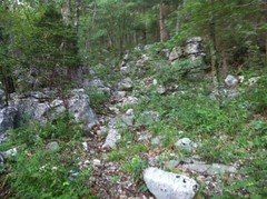
Back on the bike, I headed up the southern section of the Pocket Loop, almost all of which I ended up walking.
If it wasn't the incredibly steepness, or the rock gardens...
...it was the wet rocks, or the rocks and debris that spun out from under me. It wasn't a lot of fun.
Plus, I was itchy all over and moving so slowly that the bugs could keep up. There was a constant buzzing in my ears.
And speaking of bugs. I'd scraped my shin on a downed tree earlier and it felt a little itchy, so I looked down and noticed it had gotten covered in dirt. That's not good for a scrape. I brushed it off. Or, at least I tried to. It wouldn't brush off. I brushed harder. No luck. What the...?
Yeah, that's not dirt.
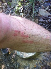
Click on that image and look at the original. Those are dozens of seed ticks. Tiny, baby ticks. And this photo only shows what was left after scraping probably twice that many off and realizing I should take a photo.
It wasn't easy getting them off. They'd come off and stick to my gloves and then my grips and everything else I touched. I kept worrying that I'd get them in my eyes. I ended up scraping most of them off with a chunk of bark, but I still found several more in the shower that night.
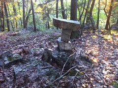
When the crisis of the ticks was finally over, I continued climbing. It was hot. I was uncomfortable. I felt low on blood sugar. There was a brief descent, and in the middle of that downhill, somebody had abandoned an old bike.
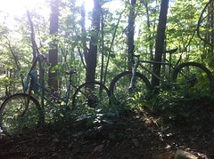
(the one on the left)
I needed to eat, and since I was stopped there anyway, it was a good spot. My lunch consisted of two Clif Blocks and the last remaining Honey Stinger block. Not a lot of calories, but who needs em? I've got too much Dave right now. It would be good to reduce the amount of Dave I'm carrying around. My brain was recharged though, and the push to the top didn't seem too hard.
At the intersection with West Brow, I was able to ride again.
When I hit the road, I was able to make much better time.
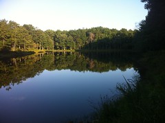
I passed the fishing lake...
...and rolled around exploring the Sawmill Camp area, looking for Hogjowl Trail. There's a small maze of roads and former roads up there. I generally knew where the it had to be, but it took a bit of elimination to find it.
Find it I did though, and none too soon. It was about 8:20 and I only had another 20 minutes or so of light in the woods and maybe 20 more on the road.
The first half mile or so was extremely fun. The trail gets way less traffic than the others in the area, but was surprisingly free of debris.
Abruptly it became incredibly technical though. Pigeon mountain is more or less terraced. To descend any face of it, you roll along a terrace, then drop over a ledge of rock and work your way down an extremely steep backslope to the next one, where you roll along again until the next opportunity to drop down. Many of the drops require you to commit to a line before you can really see what you're committing to. I rode as much of it as I could, but I drew the line at committing to blind rock gardens.
At one point, I lost the trail, but thankfully somebody had built an arrow, indicating the right way to go.
And, yep, there was even a red trail marker in that direction.
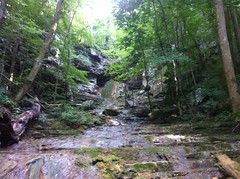
The trail crossed Nichols Hollow at the base of a dry falls.
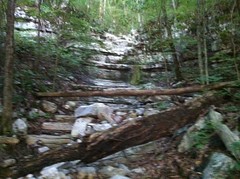
It looked like there might be even be another cascade above this one, but I had no time to check it out.
The further down I got, the more insane the rock gardens got.
Not pictured - anything ridable. By me, at least. Scott Morris would, no doubt, chuckle and show me how it's done.
I tried to stay relaxed, move with the terrain, be the deer, not the bear... But Pigeon Mountain hates me and it attacked me relentlessly. Rocks shifted, downed trees and soft ground grabbed at my my wheels, brush yanked at my hands and face, there were slip layers on the inside of switchbacks. Everything.
Eventually, I crashed. Something grabbed my back wheel and threw me against the bars. A split second later my chin drove into a rock, half buried in the ground. I didn't expect that. I had put my hands down. The slope was just so steep that they hit the ground at the same time as my face. I immediately thought of Clark, who'd gotten his face crushed during our last ride together. It was like the forest was getting even with me on his behalf. Nice jab Pigeon.
I got another jab a few minutes later in the form of a flat tire. I'd picked up a thorn over a half inch long. I almost put the new tube in without checking too. Almost.
I could hear cars on the road below. It was frustratingly close for how long it took to actually reach. The trail just kept switching back and back and back.
When it did end, at Hogjowl Road, right next to Hogjowl creek, it was the most anonymous end of any trail, ever. Unless you just knew it was there, you'd never know it was there. There was no sign at the bottom, but there had been a sign at the top, and red markers all the way down. There was one alternate route most of the way down, but it had a homemade gate across it and it looked less travelled. It's possible that's a former route and the trail might be marked at the end there. Oh well, I was down off of the mountain before dark and that's all I really cared about that that point.
Across the street, the creek was roaring. It was dark in the woods, but not quite dark out on the road.
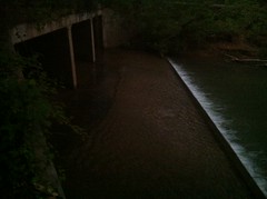
"Is that a dog? No. An otter!" It was an otter. Maybe it was a beaver. It dog-paddled on the surface, but it dove and spun and twisted around like an otter. A beav-otter. Schrodenger's otter.
I saw several large trout too.
Ok, the water's probably not too polluted. I couldn't resist a swim. These days every mountain bike ride involves a swim. It was cool and delicious. I didn't want to get out, but I had to. It wouldn't be light for long.
It had taken almost 6 hours to get to that point. I took the road back and nearly doubled my mileage in the 30 or 40 minutes it took to get back to the car. It should be clear why from this ridiculous elevation profile.

The sun was setting over lookout mountain.
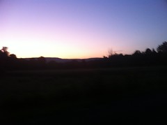
It's too bad my phone takes such poor photos in low light. It was a beautiful sunset. Soft colors. Warm little lights on the mountain. Bats were chasing moths overhead. If I hadn't been constantly pelted with tiny bugs, it would have been perfectly serene.
I grabbed some dinner at Sonic in LaFayette. It was the only thing open. Don Lolo's was even closed.
I was able to asses the damage to my face too.

Not too bad. It seems like I crush my face about once every year and a half or so. The last time was hiking the Art Loeb. Prior to that, a wrench broke loose while I was working on my truck. That one required stitches. No stitches this time though. In a week I'll be good as new.


Great read. I live about 20 minutes from Pigeon Mtn. and enjoy reading peoples stories about that place. I camp alot up there thru the fall,winter, and spring.
ReplyDeleteThe tunnels were there for the "Dinky " line to run through. It was small track that brought the iron ore from the main mines at the Pocket back to the Estelle area where the crusher and railroad were.
ReplyDeleteThe largest of the seven tunnels, the only one on the Estelle side, is only a ten minute walk from the parking area off of Hwy 193.
Many of the old road beds were from other activities after the mines closed, and before the state turned it into a WMA.