A few weeks back I mounted another solo expedition along the old forgotten route from Nimblewill to Stock Hill.
To get from Nimblewill to Stock Hill these days, you'd take FS28-1 to FS77 to FS58. In the olden days, the route was infinitely more complex and involved substantially more climbing and descending. It would seem that they really didn't like to side-hill back then. And, I guess that makes sense, as it it easiest to navigate up along creeks and ridges, especially when you don't have a map.
For this Adventure I planned on taking the old road down from Fryingpan Gap (NE of Winding Stair Gap) to Frick Creek and beyond, maybe all the way to Hickory Flats. But I'd also throw in a side-route that the old topo maps show running up along upper Frick Creek. Maybe I'd find the ruins of some old buildings that were alleged to have existed up that way as well.
On the drive in, I took FS42 up the ridge from Doublehead Gap, and I noticed something that I'd never seen before, lying on the side of the road, way up the mountain, kind-of near where the AT crosses.
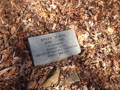
So, there was once a school there???
This was hard to believe. The maps of that area, from that time period, show nothing of the sort. For there to be a school, there must have been a community, and a sufficiently prosperous community, at that. The valley to the northeast was cut by Stover Creek. The AT bombs down through that valley these days, but in antiquity there was a road through there. Conventional wisdom would say it's a logging road, but maybe not. Maybe the valley was populated way back. Again though, the maps from that period show nothing. To the southwest, the valley is cut by the Tickanetley Creek. There are plenty of old roads down that way, and if you go far enough downhill, it's still fairly heavily populated. Maybe it was once populated that way up one valley and down the other and the school served both communities. If the school was really up on the ridge there, then it would have been a heck of a walk to school though, from either direction.
I may have to contact the Fannin County Heritage Foundation. I've seen several of their markers, and they are all very intriguing.
Oh yeah, it was rather chilly outside.
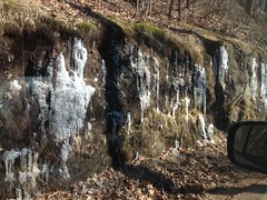
Just a bit over freezing.
I had been a little worried about freeze-thaw on the roads near the top of the mountain, but it turned out to be a non-issue. Everything was dry and solid up there.
I parked at Fryingpan Gap, in the Zombie Hyena lot...
...and took the connector trail over to the old Fryingpan Gap Road.
There are actually 2 roads that lead from Fryingpan Gap down to Frick Creek. The newer road sidehills its way down and is in fine shape. The old road bombs directly down the fall line and is prone to becoming this kind of thing:
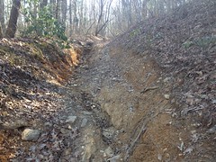
...and thus was supplanted by the newer road.
I took the old road down to the point where the newer road crosses it. I'd seen where it continues on down before, but it always looked too overgrown to be worth following. That overgrown section is what the old maps shows as the correct way to go though, so I took it.
Yep, total garbage. Deep below grade, heavily braided. I can see why it was replaced.
At Frick Creek I noticed an old bridge off to my right.
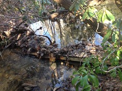
It's funny. The first time I was down there, like 10+ years ago, I thought I saw a bridge, and then every time since, I never noticed it. I didn't even see it when I'd look around quickly for it. Eventually I decided I was wrong about having seen it the first time, but no, I was actually wrong about that. It was just hard to spot.
Looks like over the years, crap had piled up behind it and swamped it pretty badly. I didn't even attempt to cross it.
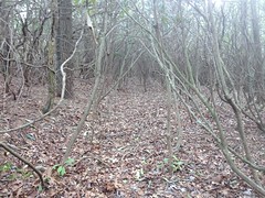
The side trail I was looking for ought to be off to my right somewhere, and after a bit of searching I found it. It was very overgrown, and very difficult to follow, but since it was notched into the backslope, I could always re-find it when I had to go around some massive tangle of downed trees.
Occasionally it was somewhat clear though, and overall it seemed like I was making ok time.
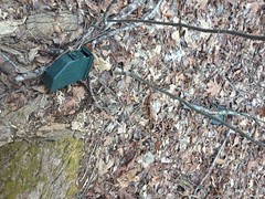
I saw this pretty regularly too.
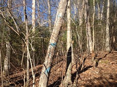
Three slanted blue blazes. I'd seen the same markings earlier on the old Fryingpan Gap Road too, and in years past, I'd seen them in other locations in the greater Blue Ridge WMA. Most recently I'd seen them along an old road leading down into the upper Frick Creek valley from Puncheon Gap. I wondered if they marked a loop from Fryingpan Gap, down to the creek, back up to the ridge, and back to Fryingpan Gap. Hmm...
Further down the road I found a few more interesting things.
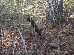
A cable.
Which doesn't tell me anything, as they were used for a dozen purposes way back.
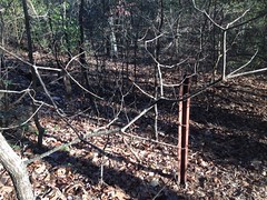
And a fence post.
Which appeared to be part of a fence line leading due east-west, across the road.
Beyond the fence, it looked like there might have been a field at one point, and it was super difficult to figure out how the road crossed it. Eventually I managed to find it, but then it looked like maybe there had been another field, separated from the first by a small stand of trees, and it was again, quite difficult to re-find the road.
That old field (if indeed that's what it was) contained a pretty big pine tree...
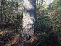
...and appeared to be bordered by the same fence line.
Past both of those, the road was a new level of overgrown, and there appeared to be yet another old field, and there were at least 2 spurs of the road that confused me, and I kept running into more of the old fenceline...
I eventually sorted it out, but I was quite confused for quite a while.
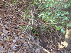
Oh yeah, I also ran into this gnarly old pitchfork tree.
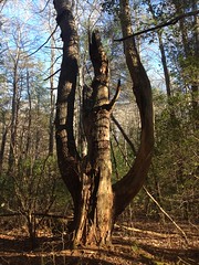
Wild.
And, man, every time I'd want to give up and declare that I'd found the end of the old road, I'd wander around and find more of it, follow it for a while, find what would appear to have been another old field, and lose the trail again.
It was slow going, and though I found that fence, and all of those fields (maybe), I never found any ruins.
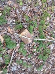
I did find an old paint bucket though.
And trash from the '80's, as evidenced by pull-tabs.
The road kept going beyond where the old map said it would. It crossed a creek at a point that appeared to have once had a bridge, and led up a little ridge. The branches there were super low.
My back got a little tired from hunching over to get under them.
Eventually I popped out on that road down from Puncheon Gap that I'd seen those blue blazes on earlier.
I didn't take it all the way out though. Instead, I whacked up to Coppermine Gap through some fairly open woods.
On the way up I found a spot where the Rangers might have had a shootout, ages ago. There were 4 ammo cans...
...a medicine bottle...
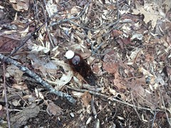
...and various other odds and ends strewn about. Glancing around, I just kept finding stuff, and ultimately piled it all up on top of that ammo can. If I'd wanted to, I literally didn't have enough space in my camelback to pack it all out.
Further up toward the gap, I saw what kind-of looked like they might be footings for some building. There was no road or trail to it in either direction though, and one of the footings appeared to be sitting on a big rock, like maybe the rock just cracked up and formed the pieces naturally. Also, the piles were fairly spread out. I eventually decided that it must be some natural formation and didn't even take a photo. When I got home though, I checked the maps, and the one from 1914 shows a structure at that exact location. No idea what it could have been though.
When I hit FS42 on the ridge it was thinking about getting dark.
But, as I hiked back, I noticed a little trail off to the right that I hadn't seen before.
It led all the way up to the peak of whatever unnamed knob that is to the east of Fryingpan Gap. Fryingpan Knob, maybe?
Oddly, it didn't appear to continue along the ridge, and there was no established-looking campsite up there. It was well trampled, but there weren't any fire-rings or anything.
Somebody goes up there just to be on the peak, for some reason. Maybe the Rangers do that.
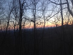
From up there, I could almost see the sun.
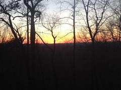
But it was definitely setting. Time to go home.
Instead of taking the trail back down, I whacked down the southwest side of the knob, and man was that slippery. It was really rocky, and loose, wet leaves on wet granite is no good.
I survived the descent though, and made it back to the car before it was officially dark, but it was pretty dark before I got down off of the mountain.
I want to say I grabbed some dinner from Shane's Rib Shack in Ellijay. That seems right, at least.
Not the best time, actually. Though I made some discoveries, they were a little lackluster, and it was just so difficult to follow that old road. Man!
It wasn't awful though, just not great, and of course, there's always next time.


No comments:
Post a Comment