I've been wanting to go for a long walk for a while, and today that seemed like the right thing to do. Specifically, I wanted to see if there were any trails between Settles Bridge and McGinnis Ferry Road along the Chattahoochee river.
I grabbed some brunch at the Dutch Monkey and drove down to McGinnis Ferry Road. There was a bunch of construction going on, no obvious trailhead and some houses really close to the river. It was clearly the wrong end to start at. So I headed north and started at the right end.
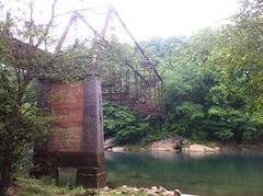
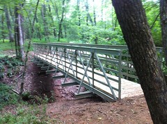
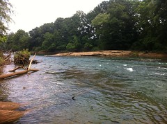
Settles Bridge:
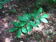
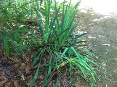
The girls and I have been all over that unit. We know it well. This time of year, it's infested with ticks. This weed covers the ground and encroaches on every trail, everywhere:
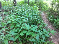
I don't know what it is, but there are 1000 ticks per leaf of it. Somebody tell me what it is. To me, it's tick weed.
I headed south as quickly as possible and before I knew it I was back at the chasm that had stopped the girls and I last time.
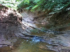
It was tricky, but I managed to cross it. The woods on the other side didn't get much traffic. There were no trails. There weren't even any "trails." Here and there it looked like people, or maybe just animals, went that way sometimes, but the woods was fairly open and it didn't take a lot of effort to get through it.
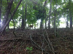
I spooked a few deer lying down in the tick weed. When they jumped up and took off and it kind of freaked me out. I've never seen deer lying down like that and I didn't expect such a big animal to emerge from the foliage.
There were quite a few deer in that area. One let me get fairly close and take a semi-decent photo.
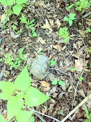
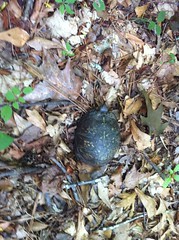
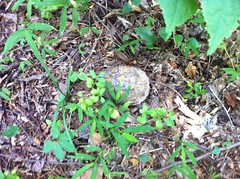
There were also several turtles.
With last weeks storms, it was cooler than it's been when I got started, but as the day ran on, it got a lot warmer. My clothes were soaked and sticking to me. I'd had to push through some brush and I was covered in bugs and little bits of debris, not to mention dirt and mud from climbing in and out of various ravines. It reminded me of a certain off-color line from a certain Pantera song. Suffice it say, I was filthy and feeling pretty satisfied with that.
That sunburn from last week was giving me a little trouble though. My arm sweat was getting bound up and barely doing it's job. Bubble skin:

Blah.
At Level Creek I encountered this balance-beam playground.
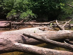
If I wanted to keep my feet dry, I had to walk back and forth, log to log, from one side to the other. Iz would have laughed at my hesitation, but I am no gymnast. Plus, there was a half inch thick layer of mud on every log that caked up on the bottom of my shoes, making them heavier and more oddly shaped with every step. I made it though, and stayed dry.
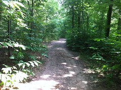
The next section was slightly more heavily travelled than the previous. I managed to get on a "trail" right away. There were a few points of interest too.
This might be a waterfall if it's raining.
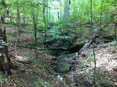
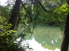
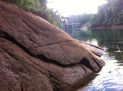
And after virtually crawling down a worn-in sidehill covered with what I think is Autumn Olive for a quarter mile, I found this nice little overlook.
It's hard to see in the photo, but there's a cliff and a big rock affording a view over the cliff with the river about 20 or 30 feet below. I haven't seen anything else like that 'round these parts. Nice.
Not too far after that, I ran into some real trails. By "real" I mean they were clearly built and there were even interpretive signs describing local wildlife. According to the sign, I'd seen muskrat prints earlier in the mud along the river.
Unfortunately there were no signs describing the plants. There is tremendous diversity in the flora along the Chattahoochee River. I recognize most of the trees, at least the ones that grow to any decent height, but the weeds and little scrubby stuff... Pfft. Right. No idea. At least for most of it. There is some obvious stuff - river cane, may apple, yucca, christmas ferns... But in a 20x20 foot square, there's got to be 40 different species of stuff growing on the ground and I don't know what most of it is. It's stratified too. For a mile or two you see mostly one thing, then later it's mostly something else, then later still, back to the first thing.
That area was dominated by this stuff:
My first thought was "some kind of hickory" but I'm not aware of any alternate leaved hickory. What is this? It's everywhere.
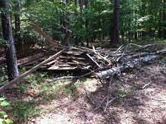
The trail led directly to another ravine, which had recently suffered an impressive washout.
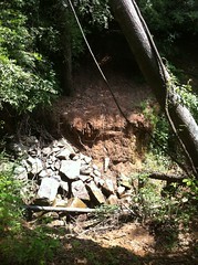
The old bridge lay in a pile on the other side.
There was a pile of materials that would become a new bridge too.
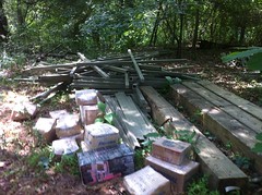
And not much further up was a recently completed new bridge over the next ravine.
They may have finished it earlier that day. The boards smelled like they'd just been cut and they were still a little slippery. It totally had that just-made feel to it.
The trails there were well developed compared to what I'd been pushing through all day.
There was even a rope swing.
And a beach.
The beach wasn't really part of the development, it was just the inside of a bend in the river. Standing there, I remembered learning in 5th grade that you get erosion on the outside of a bend and deposition on the inside. I guess my teacher knew what she was talking about.
There was yucca.
Lots of yucca.
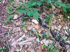
And snakes.
That one's a Black Racer. Probably my favorite snake. They like to lie up on top of stuff.
I checked out a bunch of little side trails. They mostly led to some field at the back of some neighborhood. This time of year, I like it when I find a field because all along the edge, there are blackberries.
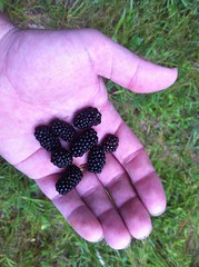
They were delicious.
One of the side trails led to a bridge, but the bridge was out.
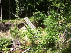
I was unmotivated to cross that ravine. It was deep, and I'd have ended up going in the opposite direction from where I wanted to go. Maybe next time.
I found an old well.
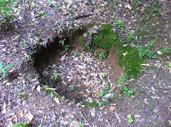
I think that's an old well.
That was the end of the clean trail. From there on, there were vague hints of trails, promises of trails, rumors of trails but no actual trails. The brush got denser and denser.
The turtles increased in frequency.
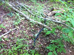
As did the dangers.
That's a punji stick - river cane, cut at a sharp angle at ankle height. I stepped directly onto it. Thank you Keen, for your tough rubber soles. I love you.
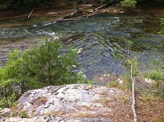
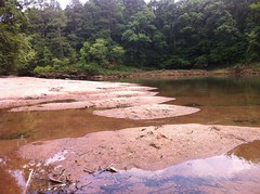
The brush kept getting denser and denser and I the only decent route through it was pretty far away from the river. Near yet another ravine, I found a path down the bank and took a break on this little shoal.

I washed my filthy hands and face in the freezing cold river and ate peanut butter granola. It was the first break all day and I didn't realize how tired or hungry I was. I thought hard about whether I should keep going or turn back. I hadn't looked at the map all day. It's such a straight shot downstream, there wasn't much point. But as such, I hadn't been keeping good track of where I was. I took a look there though, and it didn't seem like I was very far. Ok, onward.
I found another black racer.
Favorite snake.
Further up, there was an exceptionally difficult ravine crossing that I ended up sliding most of the way down into. Yet another black racer was climbing out up a nearly vertical wall. Without seeing it, I wouldn't have guessed a snake could climb something that steep. Unfortunately it was too far away to get a good photo of it and the ground was too sketchy to get closer.
I had to do some real Dave vs. Wild stuff to get myself out. I couldn't find a way up except by climbing up the branches of a tree that had grown sideways out of the bank. It worked, but it was quite a challenge.
And, after all that effort, disappointment. Not 20 feet from the bank was somebody's backyard. Or maybe not their backyard, but some mowed, grassy clearing with a shed or something in it. I didn't see any markers or bearing trees. I hadn't seen any signs and I hadn't crossed any fences. My map showed a NRA buffer zone around the river all the way to McGinnis Ferry Road. Had I stumbled onto private property? I stayed as close as possible to the ravine and headed to the river. It was dense and impassible down there. I had two options - walk through some dudes yard or walk in the river itself.
I walked in the river. For a while, there were a bunch of logs that I could walk on, and here and there I could walk on the bank in only an inch or so of water, but eventually I was up to my knees. It was surprisingly warm. It had been freezing back at the shoal. Why was it so warm now?
If anyone had passed by in a boat, I'm not sure what they would have thought.
I came around a bend and I could see the McGinnis Ferry bridge, but there was a big rock in my way and I'd have been swimming if I tried to go around it.
It took a bit more Dave vs. Wild action to get over the rock but I managed it, and picked up a "trail" for a while on the other side. There were houses up the hill. I could see their fences, but I got back in the river as soon as I could.
At last.
Getting up out of the river there was a serious challenge. In antiquity, there had been a ferry there, or at least, nearby, presumably owned and/or operated by the McGinnis's. I'm guessing that when they built the bridge, they back-filled the bank. I can't imagine anyone climbing down to get to the ferry. The bank was near-vertical and densely vegetated. I tried to get into the rip-rap under the bridge, but the water was just too deep. I just had to go slowly and work my way up, one step at a time.
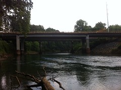
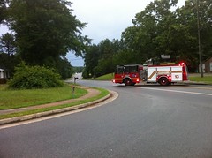
Up top, I was in the middle of the construction I'd seen earlier.
They're widening the road and building a new bridge.
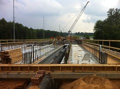
It's nice to see. Traffic is terrible through there.
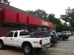
Just up the road, I stopped at the QuickTrip.
I imagine I was a sight - very dirty. This photo doesn't really capture it.
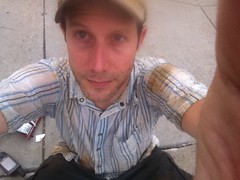
Kirk has suggested that I burn that shirt. I might have to. It's my favorite shirt, but it doesn't really get clean any more.
For all intents and purposes, I was in the middle of town. The intersection was McGinnis Ferry and Peachtree Industrial. I wondered if people thought I was homeless. If they saw them, the iPhone and GPS might have made them second guess that, but still, why was I so dirty? Maybe I'd been doing yardwork, but then why the backpack, what's that tube sticking out of it, and why did I walk in? Yes. Mass confusion.
I grabbed some Doritos, M&M's and a Coke, sat down on the curb out front, feasted and evaluated my situation. It was a long way back up river to the real woods and a lot of bushwhacking once I was there. There was a storm coming in too. It had taken almost 5 hours to get to where I was and I only had 3 and a half hours of daylight left. All signs pointed to taking the roads back. It was longer but I could go a lot faster, it would be less dangerous and there would be more opportunities for shelter if it started hailing like it did last week.
Sidewalks it was.
And it looked like the right decision.
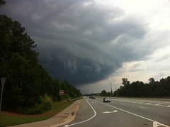
The storm moved in quickly and struck furiously. I almost lost my hat a few times. It wasn't cold though. Trees went down left and right. One took out a powerline on Suwanee Dam Road...
...forcing a detour through North Gwinnett High.
Go Bulldogs.
The pavement was tough on my feet but I felt a lot better about staying out of the woods after seeing all of the downed trees. I made it back to the car in three hours. The whole trek had lasted about 7 and a half hours. I'm not sure of the distance.
It was a weird day: difficult terrain for how flat it was; lots of off-trail hiking but no actual navigation; I got way dirtier than I usually do; I walked in a river; and all in the middle of town.
Back at home I found several ticks. Including one on my shoulder. I love ticks.
What a day. Weird hike. Bad weather. The bad weather left this gift behind though. A beautiful sunset.
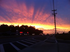
Satisfying.


Tick Weed... Haha, that's funny. Since I'm irrationally afraid of ticks, I'm gonna' keep my eye out for that stuff.
ReplyDeleteIt was cool to see the McGinnis Ferry bridge construction from below - I drive by there on the way to work and I always wonder what's going on down at river level. Now I know.