This past Sunday, you'd think I'd have done some epic mountain biking but for some reason these days, I feel more like hiking. I go through phases like that, I think. When I haven't done something for a while, I suddenly get a hankering for it, then it's all I want to do for a while, then I suddenly get a hankering for something else, and so on. These days I get that with the road bike, the mountain bike and hiking, but when I was a teenager I alternated between freestyle and skateboarding. Back then I called it the Vander Syndrome after Dave Vanderspeck who was a pro freestyle rider and skater back in the 80's and he talked about alternating between them like that in an article I read once. Google Vanderspeck when you get a chance. He came up with some rad tricks and died an odd death. Bark hard curb dog.
But I digress.
All that Oliver Creek adventuring last week made me want to explore Frozen Knob, which is right next door. I've seen maps alleging that there are "trails" up there and for the longest time I've had little dotted lines on my maps of the area. No longer! I won't stand for it.
I parked at Old 69G and a quick survey of the surrounding area yielded faint signs of human traffic uphill from there. Those led to an old roadbed which eventually led to an actual road. Not like an old abandoned road, but a somebody-drove-a-truck-on-it yesterday road. What? How did this escape previous detection? I really wanted to find out but I suddenly realized that I had neither map nor phone in my possession.
My heart sunk as it has only sunken once before, when I thought I'd lost my GPS. With the GPS though, it was like losing a companion and I felt a much deeper sense of loss. With the phone I was mainly worried that it would cost me a lot of money to replace it and I wouldn't be able to take any photos. The map was a less significant loss, but it meant I might not be able to explore as much as I'd like. I generally like to have a map with me when I'm off trail.
I'd stopped twice earlier. Once on the side of the road, right by my car, to let my GPS sync up, then again later to fiddle with my pack. Perhaps I'd set the map and phone down on the ground at one of those locations and left it. It took a bit of work but I found the spot I'd stopped to fiddle with my pack. No phone. No map. However, as it turned out, for some odd reason, I'd put the map in my pack. Why? I don't know, but I did. Ok, one down. The phone was not there though. I whacked back to the road as quickly as possible but the phone wasn't there either. Had someone picked it up? Had I dropped it somewhere else? No. I'd left it in the car. In the car! I was glad that's where it was, but seriously, that's just silly.
With phone, map and GPS, finally in hand, I hit the reset button on the adventure and made my way back up to that road I'd found earlier. It turned out it led to a campsite one way and FS69 in the other. Maybe somebody had always been camped there in the past and I never had an opportunity to check it out. Ok, mystery solved.
The map alleged a trail around there somewhere, leading up to Little Frozen Knob, but after quite a bit of looking there was nothing to be found. There was supposedly another one to the south though, so I headed that way along the road.
Along the road, as I am prone to do, I got distracted by the sound of rushing water and headed off immediately into the woods to check it out.
Yeah... Good call.
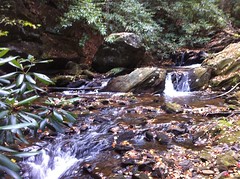

There was an old road there too and either an old bridge or ford right below the falls. It appeared that I wasn't the first to discover it though.
The old road appeared to have been the route used to build the dam that forms Rock Creek Lake.

I couldn't resist following it for a while, nor following the fishing trail that it led to which went almost all the way around the lake.


There were a couple of people camped out on the east side. It's amazing how well voices carry across calm water. From all the way across the lake, I could hear them speaking as if they were 20 feet away.
When the trail petered out I picked up Old 69A and eventually just bushwhacked down to Rock Creek where I reprised my Friday luck and crossed on some fallen trees without getting my feet wet. Ha!
The loop around the lake was a nice diversion but it didn't get me any closer to my objective. I didn't see any distinct trail where one was alleged to be, but I'd long noticed a little trail leading up the hill across from the lake, not terribly far away from there so I checked it out.
Somebody had been camping along it and had apparently heard that you can start a fire with dryer lint.

There was also a balloon nearby, lending further credibility to my one-ballon-per-square-mile theory. This one wasn't mylar though.

A densely overgrown logging road led uphill for a while, then became clear enough for a nice view of the hillside below...

...before ending abruptly.
Grrr. No trail. Fine! No trail. I headed uphill anyway.
I first crossed another old roadbed, but it ended right where I crossed it and led downhill in the other direction. Before long though, I ended up crawling my way up over a series of rocky outcroppings.
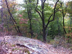
The whole western face was strewn with outcroppings and cliffs. It was tough to capture the coolness of it in a photo though.
As I neared the summit, a "trail" appeared, coming in from the northwest. It matched the location of the first one I'd been looking for. I yearned to follow it downhill and see where it came from. How could I have missed it earlier? I say "trail" because it barely counted as a trail. It was more of a "people-go-that-way". I followed it up though and once I had a line on it, it was fairly easy to follow. It led right where it should have too, up and over Little Frozen Knob and east along the ridge.
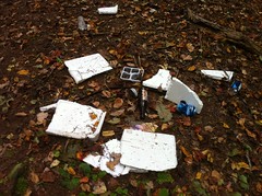
Unfortunately there wasn't much to see up there. There were a few interesting rock formations, but nothing big and crazy. The views were mostly obstructed by leaves or brush. I alternated between following a well defined trail and just going in the most open-looking direction through the woods. Several old logging roads intersected here and there and a couple of trails looked like they led out along various spurs or ridges. There was very little trash but the bits I found looked like Ranger gear.
Toward the eastern end, I did, finally encounter some points of interest.
This tree had been struck by lightning, had burned almost completely and was barely hanging on by an inch or two of wood at the base and then again halfway up.

I feared that the wind would blow it over before I got the photo.
On Frozen Knob proper, another tree was eating this ancient WMA boundary sign.

While ascending Frozen Knob, I heard what at first I thought was a deer sneezing. As ridiculous as that sounds, it sounded even more ridiculous in my head when I first thought it, but I couldn't imagine what else it could be, unless it was some other animal sneezing. It wasn't a snort. Then I heard it again. And again! I finally just stopped and stood still for a while. It never happened again though and eventually I moved on.
Not a quarter mile later, I discovered a big pile of trees that had just been cut. They still smelled strongly of sap.

I puzzled over the trees for a few moments. They hadn't been dropped across the trail, nor over a campsite. The trees themselves looked healthy. They were of several different sizes and species. There was no paint on them, nor on any other trees in the area. I could not, for the life of me understand why they had been cut. Finally though, I noticed that whoever cut them had tried a few times on each tree before finally getting their cut in the right spot. Maybe somebody was practicing cutting down trees. Hmmm. There was no oil smell though. Maybe they were practicing with a crosscut saw. Maybe the sound I'd heard earlier was the noise made by a crosscut saw. Maybe they were still practicing and had just moved to a different location. Who knows. It made more sense than a deer sneezing, but it remains another mystery.
At Low Gap, I lost the trail and spent a while looking for it. Maybe it ended there. No, I eventually found it. It looked like an old road led over the top of the knob to the east and the trail followed it.
At the top of the hill, there was this ancient orienteering marker.

"Number 2." There are markers all over the place in the woods surrounding Camp Merrill. I've found dozens of them over the years, and posts they've been removed from. This might be the oldest generation of them though. Newer-looking ones are made of plywood and a few years back they started using professionally-made-looking ones coated in reflective paint. I think this one might be the most distant from the camp that I've found yet. And, it's funny, every one of the ammo-box markers that I've found have been filled with acorns.
It doesn't look like anybody goes past Low Gap all that much from the west, or approaches from the east very often. There were a series of old logging roads leading down from the knob to Frank Creek but they were barely passable.
When I got to FS346, it wasn't dark yet, but I didn't have that much time before it would be.

As much as I wanted to backtrack and discover the source of the trail along the ridge, I knew by the time I got there, it would be too dark to follow with any confidence. Oh well, maybe next time.
I jogged along the road for a mile or so before giving that up and just marching. Man, I suck at jogging.
It got darkish in the woods around 7:15 but I made it back to the car before it was officially dark.
Once again, I managed to knock 3 dotted lines off my maps, only to add about 15 more. That's how it is. What would I do if I ever ran out of places to go.


No comments:
Post a Comment