My Adventure backlog is still 3 Adventures deep. At this rate, it'll be that way forever. Right now I'm waiting on a long running build process though, so I have a little time. Maybe this week I can find a little more and get caught up.
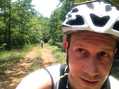
The last time Billy and I were up at Berry College, we gave it a good once over, but even after 40 miles of riding, there was still plenty left. Sunday, a week ago, we figured we'd see what else we could see.
Sometimes I do a little research on the places I'm planning on riding, and sometimes I run into some really interesting stuff. One of the roads we hadn't ridden last time was CCC Road. If you google "ccc road berry college" you'll find that there are legends galore about how it's all haunted and stuff. It's also referred to as Seven Bridges Road because there are allegedly seven little bridges along it.
"There are stars in the southern sky..." That Seven Bridges Road? Maybe. The song wasn't mentioned in what I read, so maybe not.
At any rate, if you head out one way you'll count seven bridges and if you head back the other way you'll only count 6. Thus, it's haunted, or so the story goes. After stumbling across something like that, I couldn't resist making that the first stop on our journey.
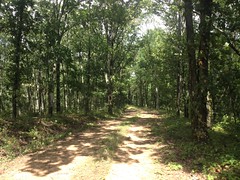
My map-printing skills left a bit to be desired that morning, and it actually took us a while to find CCC Road. It's also known as Selman Road. Or, more correctly, it's Selman Road for a block or two, then becomes CCC Road at the edge of the WMA.
We parked just past the game check station, got the bikes and ourselves all put together, and proceeded west toward a gate.
The sign at the gate seemed a little threatening, so I called the number.
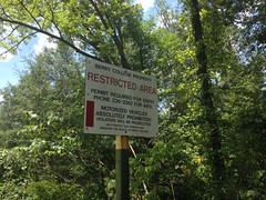
Berry College police answered and assured me that it was fine for me to proceed around the gate on a mountain bike or on foot, just not in a motor vehicle. Excellent!
We proceeded.
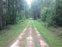
It was very hot, the sun was very bright, and the dead straight, dead flat expanse ahead of us reminded me of riding in Florida.
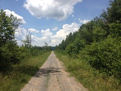
The only difference was that the road was gravelly rather than sandy.
We counted 1 bridge right at the gate. There was a culvert a ways down the road, and then in the middle of a clear cut that stretched across both sides of the road, there was some old-looking little rock construction on the north side of the road that might have once been a little bridge, but was totally backfilled now.
And that was it. No other bridges at all. The heck? Is there a different CCC Road near Berry College in Rome? At the time I figured there must be, but after looking into it since I got home, no, that was it. After re-reading the descriptions though, the road is alleged to lead to the Mountain Springs Cemetery. The road that we rode did not. Instead, it teed into another road and the cemetery was to the north. There is a road that connects the cemetery to CCC Road, and I suspect that in antiquity, CCC Road may may have followed that connector, but since then it's been cut through to the other road. Now I'll have to go back and see where that other road goes.
At the time we were puzzled, but we had plenty more to see and do, so we kind of forgot about it right away.
At the end of CCC, we turned right, climbed the Hurtin Gator, which seemed to put some serious hurtin on Billy.
We passed a group of women hiking it, and it seemed to be hurtin them too.
At O'Bryan Gap, there's like a 5-way intersection. One way is the way we'd come from, another leads to the House O' Dreams. The other 3 we hadn't explored as yet, but had planned to.
Turns out the old road directly across from Hurtin Gator doesn't go anywhere interesting. It bombs down off of the mountain and ends at private property about halfway down. There's a beat-up old sign indicating that the land is private, but man, if I ever own land with a road on it, I'm going to put up a "Private Road" sign. I've seen so many cases where the land to either side of a road is posted, but the road itself is open. A lone sign to one side of the road, just isn't enough to clearly delineate the property. I am not a fan of trespassing though, so we went as far as to check the lot lines on Zillow to determine whether it was ok to proceed. That's right. We stood there in the woods, with a smartphone, looking up property boundaries on the web. Yep. Because we're nerds. Indeed, the property boundary clearly crossed the road ahead of us.
Dangit.
We climbed back up.
It was definitely OK to the east though, so we went that way.
There was another gate nearby though, and some wild cotton growing near it.
Never seen that before.
While walking my bike over to check the sign at the gate (which said the same thing as that one earlier), I managed to somehow get my rear derailleur wrapped up in my spokes and either bend the hanger or the derailleur.
Man. I do that more than anyone I know. By a lot.
It took a little adjusting, but I got it working well enough after a minute or two. It wasn't anything terrible.
The road we were on was Lavender Mountain Road. And like the rest of the roads up there, it was closed to vehicles most of the year, and in really, really beautiful shape.
It ran along the ridge for quite a while before finally diving down off of it near the highway.
We passed a guy hiking with two kids. He was hiking with a baseball bat in his hand. We weren't too sure what to make of it. Protection? From animals? From us? We kept moving.
There was one spot with a great view of The Great Valley though.
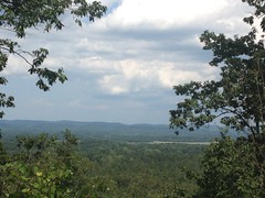
We debated what hills those are in the distance. The view was to the southeast so they weren't the Cohuttas or Taylor's Ridge. I couldn't offhand think of what lay in that direction other than the hills around Burnt Mountain but those seemed like they'd be way further away. I could see Plant Bowen to the right (outside of the frame) and the airport down in the valley too, but they didn't really help. Turns out they're ridges I've never heard of: Ward Mountain, Armstrong Mountain, Cass Mountain behind those... Might be worth a look someday, on the road bike at very least.
We ended up on Scenic Road and then Highway 27.
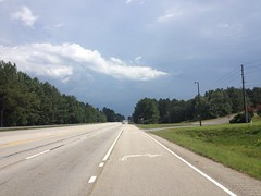
It was super hot. Goodness, it was hot, and exposed on the road, we burned through the water we had quickly.
Fortunately we were on the road, and there were gas stations. Unfortunately, the one we picked was one of those bulletproof glass guard shack type gas stations with no public restroom. They did have a spigot outside though, and that was fine with us.
The loop we'd ended up doing wasn't anything like what we'd hoped to do. We were near the car, wondering what to do next, trying to avoid backtracking as much as possible, and hoping to incorporate at least some amount of shade into the ride. The plan we ended up with was heading back down CCC, riding some stuff we'd ridden last time, coming back on a road we hadn't seen yet, and calling it a day.
And we did exactly that.
As we approached the car though, we noticed that somebody had opened the gate. It was definitely closed when we parked there, I'd called that number to be sure it was cool to go through. Now it was open. Odd. Was that like a once-a-week thing? Is it always open after noon on Sunday? Or did we happen to hit the one day a year? No idea. But hey, one less obstacle to negotiate.
On the way out the first time, we'd seen what looked like an old silo off to the left.
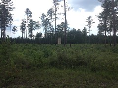
No way I'm not checking that out. I'd seen what looked like a little road leading over to it earlier too. There were signs saying "foot traffic only" though, so we parked the bikes and walked. Turned out that it would have been faster to just walk directly to it from the main road though. It was a lot further back in the field than it looked.
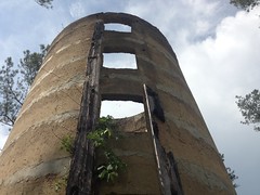
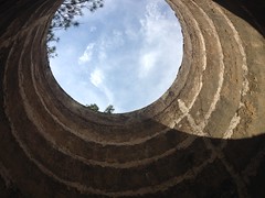
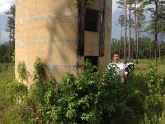
Yep, definitely an old silo. Must have been a farm there at some point. I imagine the whole area may have been farms at some point.
We took a short detour to the old cemetery, thinking maybe there was a cut-through to where we wanted to go, but there were several cars there, several people milling around, up to something, and they indicated that there was no cut-through. It occurred to us that they might have been the ones that opened the gate, needing to get to the cemetery for maintenance or something.
Near Old High School Road we saw a few deer.
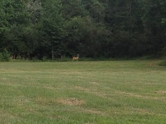
Decent sized buck there.
There are plenty of single and double-track trails, but Old High School Road is the only triple-track that I know of.
It was really nice and shady too, a welcome break from the ever-present burning murder ball we'd been dealing with all day.
Near the campus we hung a left, took that other unnamed road back to CCC Road. There was an electric fence running down the right for a while. Later it looked like a bridge had been demolished. The road just fords the creek now. Not that it's really much of a creek, or much of a road, for that matter. The trail fords the trickle.
And that was about it.
It was a nice ride. I'm not sure how many miles it was, but the diversity of trail experience and challenging conditions made up for any lack of mileage.
Berry College is a unique system. Lots of roads, but they're all so different from each other, they're all closed to cars most of the time, and some of them are really more like singletrack-on-an-old-roadbed than a road proper. It's a great system. The Pinhoti runs through somewhere to the north too. I bet there's an epic loop in there somewhere. I might have to put something together and give it a try, sometime in the next few months.


No comments:
Post a Comment