Dover Creek?
If you go to Duke's Creek Falls, from the first viewing platform you get a good look at a several-hundred foot tall cascade bombing down into the gorge. This is commonly referred to be Duke's Creek Falls. However, it probably shouldn't be, as that falls is actually on Dover Creek. Duke's Creek is the creek that it flows into, but Duke's Creek Falls proper (or at least one of the many cascades along Duke's creek) is the one that you can see from the second viewing platform.
Dover Creek heads off to the west and FS244 vaguely parallels it, at least for a while. I ended up following it myself last weekend, sidehilling forever along the south side. Along the north side, it looks like there should be an old railbed, and this past Saturday I went looking for it.
This time, I remembered to bring my map, and that made it substantially easier to figure out where to park. It's funny too, there's a campsite there, surrounded by what looks like impenetrable woods, and no evidence of any kind to support that a train ever went ripping through there. That is often the case though, and with a little perseverance, I found the old bench cut.
For a while, it was pretty overgrown. Not impassible, but I had to move branches out of the way with every step. I came around a corner though, and it was suddenly very different. The recent burn had apparently made its way down that far and cleared everything out. The railbed acted like a firebreak, so downhill wasn't very burned, but along the rail itself, and uphill was totally clear of brush and debris. All that remained were random trunks of fallen trees.
I had been following a little feeder creek so far, and where it joined Dover Creek proper there was a pretty substantial waterfall. Getting a good look at it would have required a lot of work, and I wasn't up to it at the time, but I may have to go back to check it out at some point.
At that same corner, there was an equally substantial rock fill:
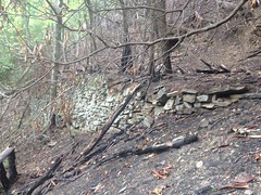
It wasn't nearly as long as the one I'd seen down by Pheasant Branch, but it was pretty long, and ironic that it was on the same creek.
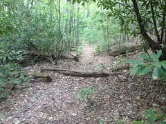
The trail ahead pretty much looked like this for a really long time:
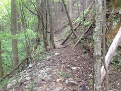
And it was so clear that I made several discoveries quite easily:
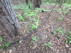
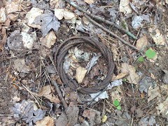
The obligatory snapped and discarded cable:
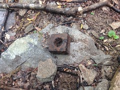
An old square nut, with threads still intact:
More cable:
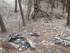
And two different cast-iron something-or-others:
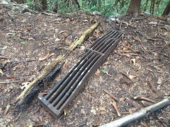
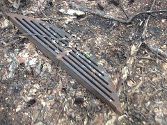
What the heck are those? They must have weighed more than 50 pounds each. Way too bulky to have been part of an old truck. I assumed they were part of a locomotive or crane, but after looking at dozens of photos and diagrams, they really don't appear to be. Maybe they were just dumped out there, but if I were doing the dumping, I'd have dumped them somewhere much less inaccessible.
No idea.
To the right, for most of the way, the backslope was super, super steep and there were all kinds of jagged rock formations.
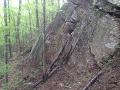
These appeared to have once had a fill spanning them, but it had long since washed out.
At a point, the backslope flattened out, the creek bent north and the old rail followed it. Before long, it switched from being cut into the backslope to lying on a built up mound in the flats. I've seen that before, but I'd never seen it go on and on like this one did. It must have been half a mile or more of build-up earth.
It's funny too, it didn't look like much. I might have questioned whether it was even artificial if I hadn't seen the transition. That seemed to be the general case too...
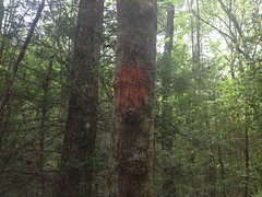
As I approached FS244, I saw signs that I wasn't the only one who'd been there in the past hundred years.
Eventually I found a few paths crossing the old rail too, but no discernible trail followed it.
I'd be tempted to declare it "reclaimed" on my map except that it was only covered in ferns, and very easy to follow, if it occurred to you to do so.
Eventually I ran into FS244 again. The trail continued across the road, but again, if you didn't know it was there, it might not occur to you to look. There was barely a path through seemingly impenetrable jungle. But, once you were on it, it became really obvious where to go.
In fact, Orange Blazes led the way.
On that side, it looked like the rail had been converted to a road before eventually being decommissioned, probably when that side had been declared Wilderness. It was wider and rolling dips and turn-outs had been cut into it. At FS244, it was barricaded by Kelly Humps.
It was wide open and clearly a popular trail, as uninventoried trails go at least.
About halfway up I noticed two old rock piles off to the right. Here's one of them:
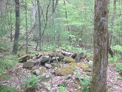
The other wasn't so photogenic.
Clearly man-made, but their purpose was ambiguous. Were they the ruins of something? Perhaps a two-chimney homestead? The stones seemed a bit large for that. There wasn't anything else nearby to shed any light on the mystery. Again, no idea.
The road forked. The left fork looked like the right way to go, but I figured I'd see where straight ahead went too. It became a skid, eventually a pig trail, and then eventually nothing at all.
The weather forecast had called for a 50% chance of thunderstorms. It had been overcast, and I'd heard rumbling earlier, but nothing too threatening. Then, out of nowhere it started pouring. Not sprinkling, or drizzling, but pouring. Storming!
Fortunately it was warm out. It had been in the 90's at the home, and it was still in the mid 80's in the mountains. The rain was a little annoying, but after the initial shock, it wasn't too uncomfortable.
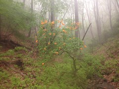
I did have trouble with my iPhone's camera though. There were Wild Azaleas blooming all over the place up there, and I wanted to get a picture, but it took quite a while to get the touch-screen to work.
I was headed towards High Gap and I figured I might as well keep going until I got there.
Sadly there wasn't much there when I did. Just a shredded old WMA sign.
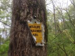
That's some weird shredding though. What in the world makes marks like that?
The descent back down the old skid was sketchy. It was really steep in one spot, the leaves were kind-of deep, and it was really wet. It reminded me of descending icy trails into the Canyon. Small steps. Keep moving. Don't try to stop too quickly. Fortunately it was only sprinkling at that point and as luck would have it, stopped raining altogether about 5 minutes later.
The other fork of the road was the correct way to go, as evidenced by more and more orange blazes.
Near Carr Gap I found a little newt on the trail.
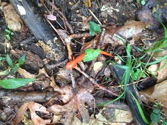
I'd seen a few less spectacularly colored ones earlier in the day, but they all ran away too quickly to get a photo. This little guy held his ground though. Thanks little guy. Other than a turkey on the side of the road in Marietta, those salamanders are the first wildlife I'd seen yet this year.
The old road climbed over Carr Gap and sidehilled along whatever mountain that is. Piney Mountain I think. I suspect that it ties into a trail that appears to run along Piney Ridge but I didn't follow it too far. It was getting late and the very far end of Piney Ridge is private. I'd like to put a few waypoints in the GPS before going too far west along that ridge. No one would likely expect you to be coming from that direction, and the border isn't likely marked.
I did find an old pine tree mauled half to death, presumably by a bear.
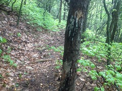
That's a really common sight in the upper Jasus Creek area, but it's been a long time since I'd seen it anywhere else.
The descent was uneventful except for another short burst of rain, and for the nagging pain in my left Achilles Tendon. It's been bothering me for weeks now, and whenever I think it's better it turns out not to be.
I followed some side trails on the way back to the car. It looked like when they converted the rail to a road, they preferred to cut a new bit into the nearby hillside rather than use all of the built-up section.
After backtracking through the burned out chunk, to that rock formation I took a picture of earlier, I decided that rather than push through the last quarter mile of it, I'd climb the backslope. The road was directly uphill. The slope looked less inascendable there than it had been looking, and there were plenty of holds. Yes, I was confident I could do it, and I was right. It was a lot of work, and crawling over the scorched earth left my hands really, really black and dirty, but before long I was on the road and it was an easy walk back to the car from there.
It rained again on the descent down the mountain, and then stormed again on the drive back home to such an extent that I wished I had newer tires. Might need to invest in a set of those in the not-too-distant future.
I ate at La Cabana, as usual, though this time I had the Pollo en Mole. It was delicious, but it comes with cheese that the menu doesn't mention. So if you don't want cheese, be aware of that.
Be aware!


No comments:
Post a Comment