Earlier this year, I rode Goat Island for the first time, and spent most of the day out there, trying to find my way around. Some of it I couldn't ride because of standing water, and there was one little bit that I didn't ride for some reason that I don't remember now. It's apparently been dry since the end of the summer though, so this past Sunday presented a good opportunity to check it out again. So, check it out, we did.
I don't remember why, but it seemed to take forever to get on the road. I remember that it was challenging to get a map to print, and then going in and out of the house like 6 times forgetting stuff, and then bailing on the super slow Wendy's drive-thru, and Whataburger getting my order wrong... Maybe there was even more, but eventually, we did get on the road, and it didn't seem like it took very long to get to the trail.
There are like 6 or 7 different "official" trails out there, but really, if you take the trail to the left, and stay left, it makes a lollipop with a figure-8 at the end. Everything else is just shortcuts to the main road, or across the loop part of the trail.
There is an interesting side trail though, that I hadn't ridden the last time, so we checked it out when we got to it.
Basically, an old roadbed crosses a spur of the river and leads all the way out to where there was once a bridge:

Only the ruins of a single pier remain today.
My dad marvelled at how abruptly it ended. If one was trusting, one might keep going on the road where the concrete starts, and just ride of into oblivion. There are no signs, fences, or anything. You just have to know to stop, which to me was obvious, but maybe not to everyone.
Somehow, somebody got a truck back there, and a family was milling around when we rode up. No idea where they came from, unless they had a key to the main gate for some reason.
There was a singletrack loop out there too, but it seemed recently created, and like it hadn't gotten much traffic yet.
I guess that area is Goat Island proper too. It's cut off from the "mainland" by a cutoff fork of the river. We didn't see any goats though.
Back on the main trail, we were moving really fast. In the spring and summer, it gets really overgrown with little grasses, and it's kind of difficult to tell where to go unless it's been mown recently. Early winter, there's no grass, and it's really, really clear.
Most of the way out on the loop part, there are a couple of overlooks, and you can see Lock and Dam Number 2 pretty well.

The lock part is that "box" on the far shore. The dam extended across the river to the near shore from there. There were apparently big iron hinges, for lack of a better way to describe them, extending up from the dam. In old photos, it looks like they could be raised or lowered to control the depth of the water behind the dam. There were doors on the lock that could be opened to fill it or closed to drain it. I don't know where the power came from. Maybe it generated its own power. I haven't dug into it too much.
Here's Dad at one of the overlooks.
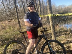
Note the caution tape behind him, which was absent at that bridge overlook.
We rode a lap of the lollipop, then took an old roadbed that I hadn't been able to ride last time because of standing water back out. I managed to crash trying to get through a busted up old downed tree, get my bars twisted, and jab myself in the thigh. Thank goodness for Ti spokes. Eventually the old road became a trail and joined the other trail.
My dad could really rip that trail. It's really windy, and I he's better than I am at staying off of the brakes these days. Dallas trails are like that - really windy and twisty. You have to lean forward to get your center of gravity low, and either ease up pedaling to be able to carry your speed without braking, or drag the brake while pedaling. It's a very particular skillset that you can't develop very well in Georgia.
On the way back, we checked out another overlook that I hadn't seen before.
Apparently there's a water treatment plant over there, and this is its spillway:

Pretty cool, actually, as waterfalls are few and far between in East Texas.
Last time I'd been there, I'd ridden a levee road out a good ways, but it was super rough and bumpy, and at the end of the day, I got tired of it and just turned around. We tried riding out on it again, and it was much less bumpy, but it wasn't incredibly fun. When we saw horses ahead we were like nah, lets just call it a day.
And so we did. Fun trail. Not all that challenging, but it has more of a backcountry feel than anything else around.


No comments:
Post a Comment