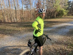
A few weeks back, Billy and I finally got together for some MTB action. We'd been trying for weeks, but between holidays and family stuff, it had been quite difficult. Eventually though, it all worked out, and we made it out to the Paulding forest for some miles on the mixed-loop.
The so-called PaCO Mixed Loop is actually a collection of various loops in and around Paulding County (PaCO) and the Paulding Forest, in particular. There are plenty of roads through the forest, both old-and-abandoned, and still-used, but most of them are (AFAIK) closed to bikes and horses, and only open to vehicular traffic during hunting season, for the purpose of hunting. Years ago (2014?) I had a discussion with some set of folks about that. I think it was the county and the DNR, but it's fuzzy now. They had to research the actual rules, and it took quite some time to figure it out. Basically though, bikes and horses can't ride roads behind gates, but anything else is fair game, including state/county roads, of which there are many, and many are gravel. If you string them together, you get a mixed loop - that is a mix of pavement and gravel. Thus the PaCO Mixed Loop. I didn't name it BTW, I just learned about it from the web page of the organization formerly known as Pauding Sorba.
You usually start the loop at the Rambo Trailhead on the Silver Comet, ride out to some road that crosses it, do one of three increasingly larger loops, and then ride back on the Silver Comet. It can be anywhere from like 25 to 75 miles. I've done all of these loops, and they're great fun, especially in the middle of the summer when you almost run out of water over and over, and your second bottle of Gatorate is guaranteed to start to ferment in the sun.
We were having none of that though. There's actually a good place to park and start, about 1/3rd of the way around the loop - High Shoals Falls. I'd never parked there before, but it always looked encticing. Yes. That would be our starting point, and we'd skip all of that Silver Comet nonsense as well.
It actually took us a little while to find the High Shoals lot. There are signs that point toward it, but there's no sign at it, and you're just expected to recognize it, which is tricky because there's a cemetery there and it's easy to think it's just the lot for the cemetery.

We figured this out though, got kitted up, and after a quick nature break in the woods behind a different cemetery nearby, got right to it.
The north end of the loop was how I remembered it. We were doing the shortest of the loops, and really, an abbreviated version of that even, so we didn't go all the way up to Cartersville. Rather, we rode some pavement and gravel for a while, then rolled into the community of Braswell. And, when I say community, I mean, hotel, convenience store, sherrif's office, and not much more.
Part of the route that I take, which is slightly different from the prescribed route, leads past what used to be an old, abandoned hall of some sort. It reminded me of a roller-rink, but I was never really sure what its intended purpose was. Well, it's been renovated since, and is now the Braswell Mountain Music Venue.

All right!
The route is pretty rough around there - old rutted roads, downed trees, and a jaunt up over some railroad tracks.
Down by the tracks, at the end of this seldom-traveled gravel road, there was a table set up, with a semi-permanent roof over it, and a bunch of campaign signs promoting various republican candidates. It seemed super random at first, but our best guess became that the property to the right was probably a deer lease, the table/shelter was some kind of sign-in, and the ads were there to promote the candidates to the various hunters.
Mmm, hm. Sherlock Holmes.
I was discouraged to find that a significant length of the road leading up over Brushy Mountain had been paved since I was last there. It was certainly easier climbing, but I think I liked it better when it was dirt.
Part of Yorkville Pass was still gravel though, so we enjoyed that.
On Hwy 101, you hang a left, then bear left at Darlene's Pizza onto some other road. Gold Mine Road maybe? There's an extended downhill there where you can get compltely spun out on a mountain bike, and like halfway down that, I heard an ominous tearing sound from behind me. Rrrrrriiiipppppp.... I turned around just in time to see Billy hit the pavement at full speed. If you know Billy, and his crash history, you can imagine the terror that gripped me.
He'd caught his tire on the edge of the pavement, and could just bump off into the grass for a second, because it was right in the middle of this big rut.
Fortunately, he seemed uninjured. He had some road rash on his hip and thigh, but everything else was fine. He'd torn up his arm warmers and shorts a bit, and scuffed up various parts of his bike, but his head hadn't slammed into the ground, and he didn't get too twisted up in his bike or anything. Signs pointed in the direction of good fortune. We stopped up the road a bit and I checked him out a bit. No dialated pupils. Full range of motion. His hip hurt a little. We had to readjust one of his brake levers, I think.
Ok though, amazingly, we were good to go.
On the various roads leading back north, I noticed that some of them had been full-on paved. Last I'd ridden them, they'd been BST'ed, but now it was black top.
Near another crossing of the same tracks we'd crossed earlier, there was this old house, that I'd seen several times. This time though, it was totally burned out.
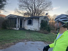
We joked about how that had insurance scam written all over it. Long ago, it was a cute little country cottage. Then they built a railroad right next to it, but not on the actual property, so no luck getting the railroad to buy up the land. Demolition by neglect ensues, eventual fire, insurance claim. $$$
Maybe. I don't know enough about insurance fraud to know whether that's plausible or not.
The roads north of that were still gravel, almost all of the way back to the car. On High Shoals Road, I couldn't remember which way to turn, and, after committing to the wrong direction, remembered that I'd experienced that same confusion in the past, and that we needed to go the other way. Billy was all "I think it's the other way" right at that same moment, which was pretty helpful in making the decision to turn around. It had seemed wrong to him too.
Yep. Just down the road, we saw signs for the falls, and pretty soon we were back at the car.
It was getting slightly dusky, but we both wanted to go check out the falls, so we changed clothes and took a quick walk down to it. We could hear it, so we were pretty sure it wasn't too far away.
Not too far away, indeed!
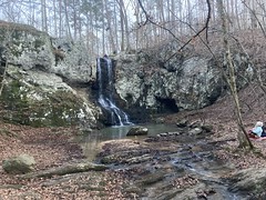
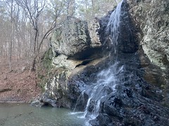
Awesome!
There were a few other folks down there. A couple that looked miffed about how many other folks were around, some guy playing guitar, his girl, and his kid, and a whole crew of drunk locals who'd climbed to the top. They were hollering and chunking rocks down periodically. I saw two of them slip, two different times too. This did not seem safe, but nobody fell, and nobody got hit with any rocks. Hey, have your fun.
I don't remember what else we did. I remember eating dinner by myself, so I probably just drove him home and grabbed something. Yeah, I need to make time to journal when it's all still fresh in my head.


No comments:
Post a Comment