This past Monday evening, while perusing gravelmap.com for some gravel nearby (to my parents' house) I noticed a longish strech a bit to the north, but not terribly out of range. What was this mystery stretch? "Chaparral" it appeared. Hmm... a 10 mile section, and a 40 mile section. The photos looked like an abandoned road that gets plenty of bike traffic. Interesting!
Turned out the "Chaparral Trail" was the first leg of the Northeast Texas Trail - a rail trail, sections of which were paved or unpaved, depending on who-knows-what decision making process. It was, allegedly, mostly unpaved from Farmersville northeast to Paris, and then from there to somewhere else, it was, allegedly, mostly paved. I did a little more research on it, but not a lot, put together a GPX file by tracing the route that Google Maps showed for the trail, and checked the weather forecast. It would be clear Tuesday, but Wednesday it was going to rain. Good, solid rain - 1 or 2 inches. This meant that Tuesday was the day! The GPX track showed 62 miles - the 52 that gravelmap showed, plus a bit of paved trail on either end. Excellent!
I called my Dad at work: "What are your plans for tomorrow?" and gave him the details. Considering that it was the holiday season, it wouldn't be out of the question for him to take the day off. Hmm... He called me back a few minutes later with good news.
I struggled that evening to get the GPX loaded into my Etrex. I'd load the tracks, click "Show on Map" and if I had more than 1 track shown, it would display some random set of them, but not all of them. Turns out, there's a bug, where it "loses its index" or something and you have to restart it, clear all tracks, restart it again, load your track, and restart it again. Then it'll pick up the tracks and show them all. Woohoo. Two hours of fiddling with it, but I finally got it working, and after a little fiddling with bikes and gear, we were good to go.
We targeted leaving the house at 8AM, and, amazingly, managed to actually get out slighty ahead of time. Since we were riding point-to-point, we had to drop a car at either end. We loaded the bikes on my Dad's car's rack, and he followed me to Paris. On the way up, I noticed that it had rained a bit the night before. Nothing significant near Forney, but the further north we got, the wetter it looked. The soil out there is this silty, black clay. If it gets the slightest bit wet, it cakes up like nothing else. One rotation, and your tires will lock right up. If it was wet along the route, we'd be in trouble.
As we drove into Paris, we passed a guy out for a run. Not a jog, but a run. He looked like a Kenyan running a marathon. Middle of nowhere, hard on the gas. I felt like he might be moving faster than we would be at the end of our ride, and my Dad and I joked about that later on.
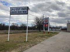
We dropped my truck at Dragon Park in Paris - a soccer park just south of the trail and took his car to Farmersville at the other end. It's always funny dropping cars for a point-to-point ride... You get a good sense of just how far you have to go as you drive back to the start. Every time, I'm like: "What have I gotten myself into?" Then, you get going, and it's fine, but it's funny to me how I always think that.
I forget if it was on the way into Paris or Farmersville, but I think it was on the way into Farmersville that I saw a trailer with a big "Locke Supply" logo on the side of it. Locke is a plumbing supply company out of Oklahoma City. They were a pretty significant customer of 4Access Communications, a company I worked for from 2002 to 2010 or so. We made a POS system that processed checks and credit cards. They liked our terminal and we wrote custom software for them that tied it into their accounting system. I flew up to Oklahoma City to troubleshoot some stuff for them once and got along pretty well with the GM up there. Seeing it brought back unexpectedly good memories.
We parked at the Onion Shed, which I guess was once a farmers' market. Maybe?
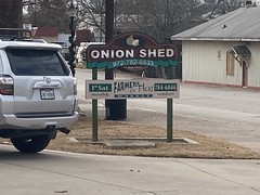
There were people using it for something when we drove up - music playing and people exercising, it seemed. I wasn't totally sure.
Two riders came off the trail, and were parked next to us, so we got to talking. One of the guys had allegedly tried to ride south from Paris some time ago and couldn't find the trail. He described it as terribly overgrown with branches poking out into it: "Like there was no trail." He eventually became exhausted and had to call his wife to come get him. He seemed to be describing the trail near Roxton, but I couldn't be sure. They'd just ridden 10 miles north and back though, and claimed that there were no rain-related issues. Ok. So, good and bad?
I guess we were about to find out!
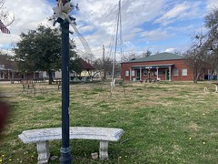
We'd driven past the lot, through the square, and back to the lot on the way in, and the square looked kind of cute, so we spun a quick lap around it, since we were there.
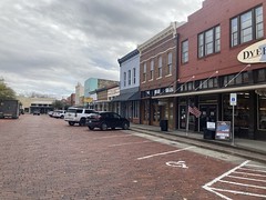

Yep, pretty cute.
But, we had lots of miles ahead of us, so we didn't spend too long sightseeing.
Let's go!

The first few miles were paved, as expected, and pretty busy with walkers, joggers, people with dogs, and a few cyclists.
Soon though, it transitioned to dirt...
...but it seemed to still be a pretty popular trail.
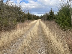
Eventually, it became a pretty wide roadbed...

...and then doubletrack.

There wasn't much traffic out that far.
Some of the "fiddling with bikes and gear" that we'd done the night before was gluing the sole of my shoe back down. The sole of my right shoe, and for some reason, only my right, started pulling off of the body a few days ago, and as of the previous evening, had become completely detached, except for 2 rivets at either end. We'd cleaned it really well, shoe-goo'ed it, taped it together to compress the shoe goo, and stuck it under a hair dryer for a couple of hours. The next morning, it seemed just right, but we'd had to make a game day decision whether to use it or swap my cleat onto an old shoe of my Dad's. It would seem like the obvious choice would be to go with the old, but less busted, shoe. However, me and Eddie had spent like 30 minutes last year, getting the cleat just right on this shoe because when it had been slightly off, it had been killing my knee. An unfamliar shoe with a maladjusted cleat had knee injury written all over it, so the less intuitive, but possibly wiser choice was to try to fix the existing shoe. We'd considered taking the other shoe with us, but didn't have enough room between pockets and camelbacks to do so.
If the shoe gave me any trouble on the trail, I could hack it back together with duct tape and/or an ace bandage, zip ties, etc. Or, if we weren't too far out, we could spin back for it. We were getting past the spin-back distance, and it seemed to be holding itself together just fine.
Excellent.
At some point out there, we crossed a concrete bridge.

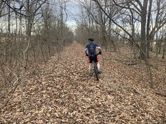
And the doubletrack got a little more narrow and raggedy. Branches started intruding from either side, and we had to stagger so that either of us could jump over onto the other's line if need be.

Then there were a series of less and less structurally sound bridges.
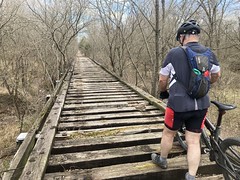
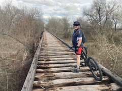
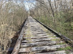
But, it wasn't like they just got worse and worse outright. There was a downward trend, but some of the bridges had been covered with wood, had railings, and were perfectly rideable. Heh. Actually, I'd hopped up onto that first bad one, thinking I'd be able to ride across it. Almost immediately, I realized that if my bars got turned sideways somehow, the wheel would drop through and I could get dumped over the side. Then I noticed how ratty some of the boards were, and how it would be just my luck that one would be rotten and crunch at some bad angle... So, I stopped as soon as I got up onto it and very carefully put my foot down on one of the ties, rather than between them. It felt sketchy at the time, and from then on, we walked any bridge with exposed ties.
Ratty bridges notwithstanding, we made excellent time for the first 15 miles. It took us just over an hour. At that rate, we'd be done in 4 or 5. We joked about this, but also joked about jinxing it, and about how it always seems easy, and as soon as you decide that it's going to be for a while, it suddenly becomes difficult. I'd definitely experienced that on some rides in Florida. So, we didn't really get our hopes up. And, honestly, expected some trouble, considering the story that guy had told us at the trailhead.
But, for quite a while, we continued to make good time.

At some point in there, we passed 3 guys on gravel bikes coming the other way. They seemed in good spirits.
There was a semi-long section that looked like a tunnel through the cedars.

You could see two tracks, but you had to dance between them. I was only able to take that photo at a particularly straight bit of it, and it doesn't really capture how much of a tunnel it was.
As we approached Wolfe City, we passed a bunch of trailside art.


There were benches too, and signs, and other "this is definitely the trail" indications. I'd marked and loaded waypoints for various gas stations, water sources, and restaurants the night before, and there were 2 in Wolfe City, but neither of us was hungry, low on water, or tired. I'd grabbed 2 Clif Bars at a gas station on the way up, and my dad had grabbed some kind of Special K white-chocolate strawberry bars that turned out to be really good. Like, he might just eat them for fun kind of good. So, we kept moving.
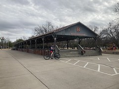
There was more doubletrack past Wolfe City, and a campground just off of the trail, near a lake.

We both kind of marveled at how the character of the trail changed so much. Being old railbed, and thus, necessarily shallow and straight, you might think you'd have about the same experience along the length of it. The silver comet, for example, is much like this, as is Simms Mountain, and the rail-trail section of the Pinhoti. But, it's not really like that. The tread changes a lot. You go in and out of woods. There are different kinds of trees on either side. Sections get more or less traffic. The gravel is significantly chunkier or less chunky depending on whatever. It get overgrown sometimes, and what it's overgrown with changes between short grass, tall grass, and intrusive trees. We value "diversity of trail experience" and there had been, surprisingly, no shortage of that.
The next significant town was Ladoina. I kept calling it Lavonia (which is a city in Louisiana) but I was corrected by a sign on the way into town. It's Ladonia.
It was clearly once a stop on the railroad, so the town square and city hall were just one block north.
There was a row of cute shops.

It looked like there were vending machines with sodas and snacks up in those shops as well, clearly targeted to trail users.
We were about 32 miles in though, and I'd hoped to stop for some legitimate lunch. Google showed the Pig and Whistle Cafe...
...but it was closed. 3PM on a Tuesday and it was closed. The whole square, in fact, was a ghost town.
"Nothing stirred."
It was eerie. I remember riding out to Seagoville from my folks' place like 10 years ago, on a super hot day, and it was the same thing. Downtown was vacant. No people. No cars. All shops closed, in the middle of the day. On that day, it made sense. Kind-of. It was super hot outside. Not this time though. Like I said. Eerie.
Even eerier was the Ladonia Presbyterian Church next door.


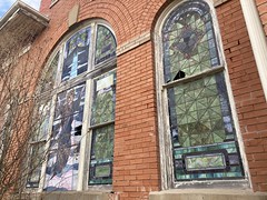
Built from 1910 to 1912, abandoned in 1978, and restored in 1997, it was again, falling into disrepair. But the grass was cut, and there were wreaths on the door. So, somebody still cares, to some extent.
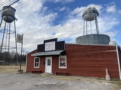
I'd marked a waypoint for a Philips 66 just up the road, so we headed off in that direction. If I couldn't get a BBQ sandwich, maybe I could get some microwaved ravioli.
Turns out no.
It was more of a liquor store with gas pumps than a convenience store.
But, they had gatorade, chips, beef sticks, candy, and other materials to refuel a tired cyclist, so we took advantage of their inventory, as well as the little step out front next to the ice machine.

Ahh, recovery.
The owners were surprised that we'd ridden as far as we had, and even more surprised that we were continuing on to Paris. Heh... When we first rode up, they were locking the door. I was worried that they were closing, but it turned out that their credit card machine had quit working and they had to swap it with the one from next door. She just wanted to lock the door while they were doing that. We actually had to walk next door to pay.
We didn't sit around for too long. Basically, just long enough to have cold legs when we got back on the trail.
Perfect!

Not far from Ladonia, we passed some truck that I guess someone had driven down the trail, driven off the edge, and flipped over. It subsequently burned. Man, I hope they got out.

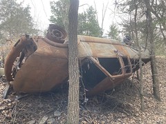


Maybe a Ford Ranger, or a Chevy S-10. It wasn't immediately apparent.
My Dad noticed that someone had come in and scavanged the catalytic converter. Probably all that was left of any value.
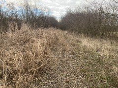
Again, the trail changed character many times. It was that doubltrack above on the way out of town. Then, it became grassy doubletrack for some time.
On the way into Pecan Gap, we crossed a road, and just had to ride down one edge of a field, divining the route by looking for the slightly raised fill of the old bed.
Beyond that, we could discern the corridor through the gap in the trees, but the trail itself was all but obscured by tall grass.
Somebody had pushed through it before us though, so we continued. It passed through another field in front of somebody's yard, then back into the woods. It passed by this old mill.
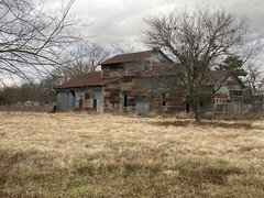
Or warehouse, or factory, or whatever that cool old corrugated metal building is. The corridor was always discernible, but this section definitely got less traffic than the rest.
Then, it became confusing. We eventually rode up on this makeshift gate. Just barbed wire strung across an old cattle guard, with a stick on one end, and a loop of barbed wire holding it closed.
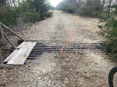
There are allegedly many of these out west. "Always close the gate behind you" is the rule. I'd never seen such a thing though. Did East Texas count as "out west" enough for this to be one of those, or was it private property ahead? There were no signs of any kind. No keep-out, no private property, no no-trespassing. Nothing. There were ribbons on the gate, so you'd be sure to see it. The corridor ahead was exceptionally clear. No downed trees, no tall grass. Just leaves. And, the trail, as described by Google Maps, and as presented to us by my GPS continued directly ahead.
We debated what to do, mused about the variations in trespassing law from state to state, but eventually decided to keep going.
We could see why the gate was there. There was a good fence to the right, but to the left, the fence separating the rail corridor from the pasture was almost nonexistent. You could see, here and there, where it used to be, but it was discontinuous at best. We could see cows out in the middle. We hoped an aggressive bull wasn't among them.
We crossed several more bridges, each junkier than the last.

The trail ahead was clear, but also clearly didn't get a lot of traffic.
After the first bridge, there were contiguous fences along both sides of the corridor, and after a while, we hit another gate-ish thing. Wire mesh, tied with additional pieces of wire. It had a rectangular sign dead-center, but we could only see the back of it. Great. Would it say "Private Property." Odds were that it would.
Nope!
"Keep Gate Closed"
All right!
So, we couldn't be absolutely sure, but it seemed pretty likely that yeah, it's ok to ride through there, but the fences to either side are a little suspect, so the corridor is fenced and gated just to be sure.
We passed through like 10 more of those gates, some more rigged-up than others.
We crossed many bridges too. A few were concrete, but most were just exposed ties. One had burned!


Goodness!
We were very careful crossing that one, making sure to stay over the support beam on the right side.
That last bridge was just outside of the community of Ben Franklin, and there was a known obstacle ahead - the Sulphur River.
There is no bridge over the Suplhur River. Or, at least, there no bridge remains over the river. There was once a railroad bridge, but it's long been washed out. Satellite photos make it look like, if you can get down the bank, you might be able to get downstream to a wide, rocky spot, and cross where it's narrow. Or, maybe cross where it's wide, if it's shallow enough there. But, would the river bottom be solid? Could we even get down the bank? Lots of questions. No way to answer them without being on location.
But, first, we had to get there.
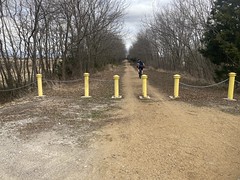
The trail was open and clear-ish for a while, just some tall grass to weave through, but after crossed a road, the trail was gated ahead. And, it wasn't a little rigged up gate. This was a bit more serious. Most importantly, to me, it was padlocked.


"If it doesn't say don't, I might, but if it says don't I won't" is my general rule of thumb. I tend to interpret a padlock as "saying don't." Google says the trail continues, but who knows how Google got it's data. Maybe the trail used to continue when the bridge was intact. Or, maybe the trail intends to continue at some point in the future, but just hasn't been developed yet. I'd read online about taking Co 38 into Roxton, instead of taking the trail, to get around the lack of bridge. Nobody mentioned even trying to cross the river. I figured maybe nobody was adventurous enough to try. There was no mention of a locked gate. Who knows?
It was starting to get dark though. We knew that for sure. We had to commit to something, and the padlock seemed like a good decision maker. Despite being able to write a paragraph about it, I actually made the decision very quickly. We backtracked, got on Co 38, and followed it north.

Co 26250 allegedly led back to the trail, so we tried that, but somebody had strung a bit of electrified fence across it. Goodness. It was just a single wire, and in the dark it was very hard to see. I happened to ride right up on a ribbon, so I could see it, but there was no ribbon over where my Dad was, and he ended up riding right into it. Fortuntely it was low enough, that his front tire pulled it down, and he also maanged to stop before it could pop out from under and get him.
There is similar electric fencing keeping the goats in at Oglethorpe, and Sophie dared me to touch it once. Apparently all the college kids touch it, and she'd touched it. It kinda burns, but doesn't actually burn you. It feels like it burns, I guess, but doesn't. Who knows how strong that wire was though.
Again, Google says that the road beyond is a county road, but again, who knows if Google's info is up-to-date. IDK how to interpret an electric fence. There was an open field behind it, but no obvious livestock. People just gate roads sometimes, for whatever reason, right or wrong. Ivylog Larry and "Old Steve" up Cashes Valley come to mind.
Whatever. We didn't really know what the condition of the trail was, even if we were able to get to it. For all we knew, that was the section the guy at the trailhead had been complaining about. It would kind-of make sense, if he'd made it to there from Paris, and gotten worn out from bushwhacking.
It was officially dark, too, so we backtracked and took Co 38 all the way to Roxton.
It was tricky to find the trail in Roxton. Again, we had to just look for some slightly raised ground in the vicinity of where the GPS track says it should be. That led through kind-of a park and down a driveway next to some seed silos. We never saw where it went in the other direction, so we couldn't evaluate how passable it was from Roxton, heading southwest, but we eventually found official Northeast Texas Trail signage neading northeast, and got right back on the trail.
There was a short section with fresh, compacted gravel down. I guess it's being prepped to be paved? Past that, it was alternately clean doubletrack and narrow singletrack, all but taken over by tall grass. There were Road Closed highway barriers at every road intersection, and wire mesh strung across at some of them. It seemed that wherever they were successful at keeping trucks and ATVs off the trail, it got spongy and overgrown, and where they were not, the trail was compact and rideable. Kind-of exactly the opposite of the intent!
We stopped at one point to rest and eat, but just kind-of chucked our bikes down and left our lights on and red lights blinking. A road kind-of paralleled the trail a few hundred yards to the north, and we saw lots of cars drive by. But, after 10 minutes or so, we saw what looked like two cars drivng straight towards us. I joked that whoever was driving those cars might have thought they saw aliens and were headed over to check out the crashed flying saucer. It was just a joke, but indeed, something like that was going on. Whoever it was was coming over to check us out. Best guess was that they saw our lights at the back of their property and got suspicious. Understandable. We were on the trail though and there was a fence between us, but still... We figured we'd get moving.
Turned out it was a truck and one of those side-by-side ATVs. They stopped at the fence line, but were facing each other, not us. The guy in the truck honked and the other guy came over to him. Then they started talking to each other. It's not impossible that it was a coincidence. Nobody said anything to us at all. I kind-of waved as we got going again. Nobody followed us. No idea.
That section seemed pretty endless. Maybe just because it was dark though, or maybe because we'd been riding for like 7 hours. We were getting close to Paris though, so we felt pretty good about the progress we were making. We eventually popped out beside somebody's house and crossed a road. The corridor beyond was unrideable. It actually, pretty well matched the description the guy at the trailhead had given - terribly overgrown with branches poking out into it: "Like there was no trail." I couldn't imagine this was the bit he was describing though. We were like 5 miles from the trailhead in Paris. He couldn't have gotten exhausted that close to the start. Right?
Maybe it only goes a few hundred yards. Nope. You could walk it without too much trouble, but I'd call it unrideable. My Dad was certain that it couldn't be trail, but he had no GPS, and I was still on the track on mine, and it felt like an old rail corridor. Maybe this section is unfinished? Maybe this section of the trail diverges from the corridor for some reason? Maybe you are, in fact, supposed to go this way? I've followed Karlos' routes through crap just like that, but his routes aren't formal state trails.
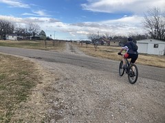
After about a quarter mile of no improvement, we turned back and took some roads toward town.
We'd seen a power plant in the distance as we'd driven out of town that morning, and we ended up riding right by it. Steam from the cooling towers just pours out over the road there.

We kept riding in and out of warm pockets of air as we passed it. I'd never been that close to anything like that before. It was surreal, especially at night.
Speaking of surreal, it always seems surreal to me to be riding down the shoulder of a highway at night. It's so opposite of the experience I usually associate with a highway. There are no cars. It's pitch black except for your light. You can't see anything to either side. You're moving comparatively slowly to how fast you'd be in a car. During the day, you'd be pretty exposed to the sun, but there's no sun. It's just all wrong. I'd done it a few times, but my Dad hadn't. I wondered if it seemed weird to him too.
We finally crossed where the GPS track said the trail ought to be, and it was an active rail.
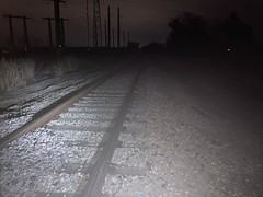
What even? A mile west it had been an unrideable, abandoned corridor. Did the tracks end shortly after crossing the road? Did they diverge to the north? It wasn't a mystery we felt like solving at the time, so we just accepted it and took more roads into town. We needed to get to 24th street, and we were on 6th street, but the next street was 4th street. ??? It just kept getting more surreal. We jogged south when we could and picked up the Trail de Paris - a paved trail that makes up part of the Northeast Texas Trail but doesn't follow the old rail corridor proper. That took us over to the street we were parked on, but I first got us off of it one street too early, and then after realizing my mistake, got us off one street too late.
It took a minute to figure out where we were. I tried searching for Dragon Park, but no local Dragon Park came up. If I'd just have looked around though, instead of having my face in my phone, the solution would have presented itself. Fortunately, my Dad was looking around, and recognized a gravel trail that he'd seen a lady jogging on when we'd parked that morning. We were just on the other side of the park from our car, one street over. Ha! We took that trail west. Fortunately the car was still there, and bam! Done!
70 miles in total. 8 and a half hours total, maybe 7:45 of riding time. Not bad at all!
No mechanicals. No injuries. Copious Adventure.
Just right.
We threw the bikes on my roof, drove back to Farmersville, where it seemed cold compared to how it had seemed in Paris, picked up my Dad's car, drove home, had some delicious dinner that my Mom had made earlier, passed out, and slept well all night.
I think that might have been my Dad's longest ride. Certainly the longest contiguous ride. We've done plenty of 50+ rides, and he's done some 24 hour team events, where he may have ridden farther than that in a 24 hour period. If not the longest, definitey up there, and almost all dirt. Couldn't have been even 10 miles of pavement. Nice!
It seemed like we made the right decision to go for it yesterday too. Today, I woke up to rain, and it's been raining all day. It might freeze tonight.
RIP Dallas trails.


No comments:
Post a Comment