On the way back from the TNGA start, I took the scenic route. Hwy 76 is a beautiful drive, and if I'm up that way, I like taking it, even if it's the long way home. It was especially nice that day, as there were lots of low hanging clouds nestled up in between the mountains. It wasn't fully overcast though, just random clouds. Some up high, some down low.
I wasn't just enjoying the drive though, I did have a plan, and that plan involved Brasstown Bald. It had been years since I was last up there, and I wanted to see if I could get some information that I failed to get last time.
So, I hung a left on 75, a right on whatever that road is that leads over to Jack's Gap, and another right up to the top of the mountain.
I've hiked up to the top 6 or 8 times already, and I was feeling lazy that day, so for the first time in 20+ years, I took the shuttle. Ultimate laziness.
There are normally gorgeous views in every direction from the top, but not that day. It was completely socked in.

Just my luck.
No matter though, I've seen the view, many times, in all conditions. I guess technically, now I've "seen the view" in these conditions too, degenerate as it was. No matter also because I wasn't specifically there to see the view. I wanted information. Information!
Specifically, there are a bunch of old photos of logging that was done in the area that I had tried to get shots of in the past, but a bunch of them turned out all blurry. I was able to get those this time.
This spot, I've actually been to:

It's at or about 34.757798, -83.796406, west of Low Gap Creek. The trestle is gone, but the abutments are still there. The train is heading south in the photo, and there's actually a switchback ahead. I wonder if the guy that took the photo had to operate the switch.
The rest of these, I'm not sure where they are, but I've wondered if I could figure some of them out.


In addition to those old photos, there was additiona information that I was interested in. Maps!
There's a small exhibition kind-of near the logging photos, featuring a slightly creepy animatronic Arthur Woody, manning a forest service desk, in some old forest service office. Arthur Woody, for context:

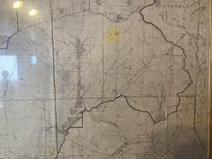
On the wall behind "him", there's a map of the National Forest, from 1930. Interestingly, it's a map of the Blue Ridge Ranger District of the "Cherokee National Forest" (not Chattahoochee yet), but it shows the forest as it was during a period for which I have no other map. I have USGS maps from 1914, and 1947, and a TVA map from 1936, but the TVA map shows very little detail. I saw the map last time I was up there, and got a crude photo of it, but it was largely blurry. I needed to get up into the exhibition to get a set of good photos. The last time I was there, I was very pressed for time, and though there were people working, they were busy with tourists. The last thing I wanted was to just get up there without being able to ask, get in trouble for doing it, and never be allowed to get the photos. So, I figured I'd come back eventually, be able to ask, etc. etc. As luck would have it, when Brasstown Bald is fogged in, hardly anybody wants to go up there. There was staff, they weren't too busy, I was able to get permission to take photos, and TA-DA, photos!
I started at the top left, scanned right, then back left, then back right, until I had shots of the whole map. I also tried just takinga panoramic photo of it, but it got super bent and weird. No idea why. It would seem like that would be the best way to do it. Some of the photos didn't turn out so great, but they were good enough. I should be able to stitch them together, eventually, with software.
Meanwhile though, some interesting finds follow...
Blue Ridge Lake (AKA Lake Blue Ridge) was once The Toccoa Reservoir and Tooni Mountain was Towonee Mountain:

The Cooper Creek WMA area was surpisingly unpopulated:

Trail Ridge was Train Ridge, and there was a proper road leading across the varios ridges of the Upper Chattahoochee towards Sheep Rock. Also Tom Elliot lived in the old Vandiver place, I guess:

The Forest to the east of what's now Hwy 192 was the Nantahala National Forest:

Various Upper Chattahoochee creeks have very different names:
There are 2 roads leading north from Tesnatee Gap, one became the Richard Russell Parkway, but the other, I've never explored. Also, the toll road is shown as a trail:

Pine Tar Knob is Tar Factory Knob, apparently there was a Rogers Mill on Rock Creek, and a food plot at the end of FS766 was once the Hughes Homestead:

The Blue Ridge WMA was once the Cherokee Game Refuge No. 2. Noontootla Creek was Noontootly Creek. The road led up along the creek, hung a left on the Appalachian Trail, over to Hickory Flats, and up to Hightower Gap. The whole length of the road was populated. There was a Newberry Mill at the bottom end of Noontootla. Homes along Winding Stair Gap Road... So much in this map:

Greasy Mountain area was "State Game Farm", Little Sal Mountain was Salls Mountain, and the Gold Coin trail existed back then, running along Little Sal Ridge. There were homes all along Mauldin Creek, and all through the area north of Ward Gap in that general highlands area up there:

Lance Creek was called South Fork (of Jones Creek), the Etowah below Hightower Gap was also just called Montgomery Creek:

The Hickory Flats Cemetery was called New Bethlehem Cemetery:

...and tons of other stuff.
So cool to a map nerd.
I didn't just obsessively gather information though, I also walked around the observation deck.

The eeirie observation deck, that is.
I noticed a rabbit hopping all around too.
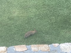
What's up, doc?
It was summer, at the time, and generally warm out, but the temps up at elevation, in the clouds, were quite nice. Chilly even:

There's a benchmark up there, that I knew was there, but couldn't find. I eventually asked one of the staff, and it turns out it was behind a locked panel/door thing on the stairs leading up to the fire tower.

I guess either that panel/door thing was open the first time I saw it, or maybe didn't exist back then. Who knows?
I did the rest of the touristy stuff up there, watched the little movie, talked to people, etc. and eventually took the shuttle back down. It was kind of a memorably trip actually. I'd never been up there just by myself before, and never paid as much attention to the exhibits before.
As I was walking to the lot, several road cyclists entered the lot as well. They'd just climbed the road up from Jack's Gap, something that I've actually never done. These were older guys, too. Older than me, so it gave me hope that some day I'd be able to do it. Not that day though.
I passed Trahlyta's Grave on the way home. The whole gap is a big traffic circle now; way better than the old stop signs.

I ate at Rooster's outside of Dahlonega. This time I remembered that they put pickles on eveything without telling you, and specifically asked for no pickle. Still got a pickle though.
They had this kind-of funny sign behind the counter too:

Huh huh.
The Cincinati Womens Open was on TV too, and apparently some company called Hologic had advertising everywhere during the match. All I could think reading it was "Ho Logic" though, and that also made me chuckle.
Goodness. I think I was getting tired and delirious. When I got home, I crashed on the couch, got up for dinner, then crashed again until the next morning. Yeah, I was definitiely tired.


No comments:
Post a Comment