Ever since TNGA 2019, I've been meaning to explore the far west reaches of the Pinhoti trail. Back in 2019, it seemed like it would be a lot of fun if I hadn't already been riding for 4 and a half days when I hit it. I kept putting it off, and putting it off. There was always something else to do. Then I forgot about it for a while. I'm not sure what jogged my memory, but a few weekends ago something did, and I was like "That's right! I forgot about that trail!", and I felt driven to explore.
Sunday morning, I woke up at a reasonable hour, grabbed some lunch, and headed west to the town of Cave Spring. I parked at Rolater Park, through which the Pinhoti passes, directly.
It was all vaguely familiar. The last time I'd been there though, it was the middle of the night, and it had a much different vibe. For one, it was completely deserted except for Honcho sleeping in his running truck by the Hearn Inn. This time, it was the middle of the day, and there were people everywhere, doing park stuff.
I noticed a bunch of other buildings, on the other side of the park from the Hearn Inn too.
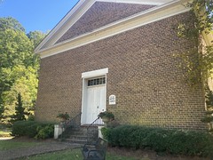
There was The Olde Baptist Church:

There was some other old house that, from the number of cars directly out front, looked like it was hosting some event at the time:

There was, of course, the Hearn Inn:

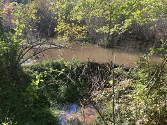
Adjacent to the Inn was a lake that appeared to be maintained for swimming, but it looked closed at the time:


I made use of the facilities for changing...

...and noticed this funny sign on the outside of the building:

The crude "Dogs Be On Leash" was funny enough, but I first interpreted "No Metal Detectors" to mean that they were specifically forbidden inside of the bathroom, as opposed to being forbidden in the park, in general. I mean, maybe that's what it means, and there's some metal detecting subculture that I'm not familiar with. IDK, the more I thought about it, the funnier it seemed.
You can't go to Cave Spring without seeing the actual Cave Spring, so I did that.
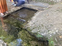
I suspect the actual spring is to the left inside a building and the above is just a touristy thing where the water pours out of a pipe from the real spring, but honestly, I'm not sure.
Whether it's the real spring or not, that thing above feeds a pretty big lake.

And there are trout constantly swimming upstream toward the spring.
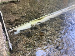
Some guy said that sometimes they go in and hang out for a while before eventually coming back out. They have to jump a little barrier in both directions, but they do it all the time.
There was a park dedication near the lake:

Yeah, pretty nice place. But, I wasn't there to check out the park. I had lots of miles to cover, and I didn't want to spend too much time at one end of them, so I eased out the west exit and started heading south.
...where I immediately encountered the Cave Spring Church of God and figured "Ok, one last photo."

For real though, after that, I began riding south, in earnest. I'm not sure how far south I followed the road before picking up the trail itself, but it felt like a while. Again, this was the first time I'd done it in daylight, and the trail was a lot easier to spot.
Almost immediately upon entering the woods, I passed this smashed old tree stand.
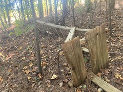
I hadn't noticed it in the dark the last time, or if I did, I don't remember.
There was also this "destination sign" or whatever they're called:

I didn't remember it from last time, and even in the dark, I think I'd have noticed that.
The trail was very pine-needly.

Pine needles are great for protecting the trail surface, but they're only great to ride on when the layer is pretty thin. This layer was right at the boundary of being good to ride on. It was mostly great,but a little thick here and there. The last time I rode through there, the rolling dips just ate me alive. After the initial descent, there's a long, steady climb, and there's sort of a minimum pace that you have to be able to keep to be able to take advantage of each dip and not have to just climb out of them. I was able to keep that pace just fine that day, except when the pine needles were thick, and I had a lot more fun than the last time.
Further on the forest became a lot more mixed and the trail was a lot less pine needly.

I had the greatest time riding too. It's unfortunate that there aren't a ton of rideable miles out that way, without also including gravel roads, because the singletrack is really, really nice. I shouldn't even call it singletrack. It's more like 3/4 track. It's difficult to push your bike and have room to walk next to it. Not that I had to do much of that the other day.
I eventually crossed the interestingly named Santa Claus Road...

...and had a little trouble finding the trail on the other side.
The Mountain Home Road crossing was equally confusing, but after figuring it out, I crossed this neat little footbridge almost right away...

...before riding more and more of the same great singletrack as before.
At a point, I crossed Esom Hill Road, and the trail on the other side clearly got a lot less traffic. I wasn't even immediately sure that the opening in the woods was the trail. The tread was a little overgrown, and there were branches hanging down. I want to say I had to cross a little creek too, and had to dismount to do so. Pretty soon though, the trail hung a hard right and picked up an old rail bed.
There was a bit of a wetland to the left, and more than 1 beaver dam across various feeders leading out from it.
There were nice bridges over the feeders, I guess just lain over the old trestles.
The trail eventually diverged from the old rail bed and made its way along the northern side of a lake.

I ran into a through-hiker somewhere in there too. He looked like he'd been on the trail for a while.
Right before I crossed Jackson Chapel Road, there was another trail sign.

At Jackson Chapel Road, it was difficult to tell where to go. There was what looked like an old parking area across the road. Or, I guess I should say, there was an open, flat area up the hill on the other side of the road, where it was clear that in the past, people had driven up the hill and parked. It now had cables strung across the various "drives" with signs saying "No vehicle traffic" though. Between the cables and the trees, there was no obvious way to get around the cables, on bike, horse, or foot. Maybe that's not the trail?
I'd had trouble finding where to go on both previous road crossings though, and had to jog left or right a bit at each, so I rode up and down the road for a while, looking for where to go. There were various gated side roads, all marked private, and none looked more Pinhoti-like than any other.
I eventually decided that the trail must continue directly across the street, and I found what looked like a spot where people maybe went, just up through the trees.
On the other side, I found a bunch of blue blazes.

Not the white blazes I'd been following though.
???
Some of them looked like they had been painted over white though, unless they'd just faded really badly. I couldn't tell. I knew the Pinhoti continued all the way to Mount Cheaha though. I'd crossed the Alabama sections many times. Maybe it's blue-blazed in Alabama? I wasn't sure. If so, it struck me as odd that the blazes didn't change color at the border.
It all gave me a bad vibe, but I'd been in that situation many times before, including just recently crossing Esom Hill Road, and continuing on was, in fact, the right thing to do.
Not 100 yards up, there was a very welcome Pinhoti sign, verifying that yes, this was, indeed still the Pinhoti, and I wasn't just on some random person's land, about to get shot.

From there, it was basically one really long, sometimes pretty steep climb, all the way to the Alabama border. Almost immediately, the trail passed through what looked like mines of some kind. There were pits and tailings everywhere, and the trail just wove between them. They weren't super deep, but they were everywhere.
There was also a memorial in that general area, though I couldn't tell who it was dedicated to.

The trail was more of that three-quarter track that I'd ridden earlier, but a lot steeper.

I felt good climbing, but it was quite a climb. It looked like it maybe got more traffic than the previous section, but not a lot more. That kind-of made intuitive sense at the time. According to the Georgia Pinhoti Trail Guide, which I'd read some previous version of, many years ago: "Non-motorized mountain bikes are allowed on all sections except from Bear Creek Loop to Mountaintown Creek Trail." But, I wouldn't imagine most folks would be too keen to do a super steep out-and back way out at the border. They'd likely skip that section and just do some sort of trail-gravel-road loop.
At a point, I rode up on this shelter, which struck me as odd. You usually only see shelters on hiking trails. There is one on a multi-use trail in Pisgah, Black Mountain, I think, but I think it's literally the only one that I've ever seen.

Was this section hike-only? Was I poaching the trail? I certainly didn't mean to be, but the fear that I might be washed over me, standing there.
Setting out, I'd felt confident that all of the Pinhoti in Georgia was open to bikes, except for that one bit near Mountaintown, and there have been efforts in the past 10 years to realign that section and make it open to bikes such that the whole of the Georgia Pinhoti is open to them. I "knew" this from reading the trail guide, and talking directly to various members of the GA Pinhoti Trail Association over the years. But, indiations in the field were starting to make me wonder: the blue blazes, how steep the trail was, the obvious lack of traffic. If you hike and ride enough, you recognize little telltale signs indicating what kind of traffic a trail gets too - tire tracks, foot prints, subtle widening and build-up on the outside of curves on bike trails, creep on the outside edges of hiking trails. I hadn't seen any of that though. Nothing to distinctly tell me one thing or another. The trail was steep, but not any steeper than other sections that I'd ridden in the past. It made sense that it didn't get a lot of traffic. I had interpreted the "no vehicle traffic" signs to mean "don't try to drive your car up here. Neither bikes nor horses are "vehicles" under Georgia law.
I eventually kept going, both because I was already well commited and pretty close to the border anyway, and because there was no definitive indication, there on the ground, that the trail was closed to bikes, and my general rule of thumb is "if it says don't, I won't, but if it doesn't say don't, I might".
The trail got rockier as I climbed...


...and I had to walk two sections for like 100 yards each. Again, though, there are sections on Dug Gap Mountain that are equally rocky...
I eventually reached the border, and there was this cool marker there.


I kind-of expected to see a carsonite sign with the little bike, hike, horse stickers on it at the border there, but no, there was nothing of the sort.
It made me very uneasy, so I didn't hang out at the border long.
The descent back down was pretty fun. I had to walk part of one rock garden because I got bumped off line, had to stop, and it was just too bumpy to get started again. Other than that, and that one super chunky bit above though, I had little trouble with the descent.
About a quarter mile from the road, I had a two-wheel slide in some deep pine needles while hanging a sharp left and ended up brushing my left shoulder on the bark of a pine tree. If I'd hit it a little harder and a little closer to my neck, I might have broken my collar bone. Lucky, lucky. Instead, I just ended up with a dozen little fine slices that bled and bled, but were ultimately just superficial. It sucks to brush pine bark, but it was way better than the alternative.
At the road, I consulted my map and debated which way to go to get back to Cave Spring. I ended up heading south on Jackson Chapel, which bent around east almost immediately, following that past the other side of that same lake I'd seen earlier...

... then jogging north on Mountain Home Road, before picking up Santa Claus Road, and riding the full length of it.

It was mostly dirt, but the far end of it was paved, near this other lake.

Lots of lakes that day.
From there, I picked up the same paved road that I'd driven in on earlier, and took it all the way back to the truck.
The park was somehow even more bustling when I got back. There was a huge gathering of people at the pavilion nearest to the lot I was parked in, and they had a big game of cornhole going. One of the guys was giving some girl trouble because she wasn't super accurate: "I get it, you're just not very... athletic." and she was like: "Come on! I just don't play cornhole very much... I've played [long list of lifetime team memberships and athletic achievements that I don't remember now]" and I got the idea that the guy was pulling her pigtails but legitimately didn't realize how accomplished she really was. Ahh, high school.
I got dressed, packed up, and milled around town for a bit, looking for something to eat. The only place that was open was the A and B Creekside Restaurant (or something like that) so I parked and went inside. There were like 6 people waiting ahead of me, and after 15 minutes of no one even showing back up at the host podium, I figured they must really be backed up and pursued other accommodations.
I ended up eating at Jefferson's in Hiram - fish and chips. It was... pretty good. Not great, but I'd eat there again.
When I got home, whether I'd poached that trail was wearing on my mind, and I spent quite a bit of time trying to figure it out. It turns out that the section in question was Section 13, located on Indian Mountain. The Alabama side of Indian Mountain is part of the Forever Wild Land Trust, and the website for that tract says "Recreational opportunities abound in this picturesque locale, including hiking, camping, hunting and wildlife observation." It doesn't mention bikes or horses, and could be interpreted to exclude them. However, the Forever Wild Land Trust section starts a bit west in Alabama and ends at the Georgia border. So, that description doesn't apply to the section in Georgia. I took another look at The Guide to the Pinhoti Trail in Georgia, on the website of the Georgia Pinhoti Trail Association, and it looked like it was updated in 2021. On the front page, it alleges that it "Covers Sections 14 through 31" but then the very next line alleges that it covers "Alabama State Line to Benton MacKaye Trail" which are inconsistent with one another, as the trail from Jackson Chapel Road to the Alabama border is in section 13. So, either it really "Covers Sections 13 through 31" (or at least part of Section 13) or it covers "Jackson Chapel Road to Benton MacKaye Trail". In the introduction, I read "Non-motorized mountain bikes are allowed on all sections except from Bear Creek Loop to Mountaintown Creek Trail" which made me feel semi-confident, and further down in the introduction, I read "The only overnight trail shelter along this part of the Pinhoti Trail is the Spring Branch Shelter, 0.8 mile from the Alabama state line" and since that's inside of section 13, it made me think that yeah, maybe the guide does really cover Section 13, or at least part of it, the "Alabama State Line to Benton MacKaye Trail" is correct, and the bikes are allowed anywhere but that bit by Mountaintown might also be correct. I felt more confident when I saw on page 8 that mileage was given for "Alabama – Georgia state line to Old Jackson Chapel Road" as "2.7 miles (mileage for Georgia portion of Section 13)." Then, pages 10 and 11 describe "Section 13 (in part) and Section 14 Alabama - Georgia state line to Cave Spring, GA (U.S. Highway 411)." Yep, feeling even better now. But, then on page 12, in the section titled "Section 14 (continued)" it states "Mountain bike travel is prohibited south of Old Jackson Chapel Road (Section 13)." and "Horse travel is prohibited south of Old Jackson Chapel Road (Section 13)." While the trail leads due west from Jackson Chapel Road, a small part of the trail does lie south of a small part of the road, and I suspect they mean to indicate that the trail in section 13, in Georgia, is closed to bikes and horses.
IDK if I just missed that way back, or if it wasn't mentioned, or if the rules were different, or what, but it looks like I was wrong, and it sucks.
It would be great if, in the field, there were those little no-bike, no-horse, yes-hike stickers on it, like there are on the east side of Jackson Chapel Road. It would also be great if The Guide to the Pinhoti Trail in Georgia stated that it "Covers Sections 13 (in part) through 31" rather than "14" through 31", and if it mentioned the access rules for Section 13 at the top of the page that describes Section 13, rather than after the page that describes Section 14. And, it would also be great if it stated "Mountain bike travel is prohibited west of Old Jackson Chapel Road (Section 13)." and "Horse travel is prohibited west of Old Jackson Chapel Road (Section 13)." At the end of the day though, if I'd done more thorough research, I'd have gotten it right, or at least thought to email somebody about it. The information was out there, if difficult to find and interpret correctly.
Other than poaching that one section, I really liked the trail. I need to explore the area more. I'll bet there's a decent road/gravel/singetrack loop to be done out there.
Next time, I'll just remember to avoid Section 13.


No comments:
Post a Comment