I met the E at Dahlonega Wheelworks around noon. He'd been fielding last-minute phone calls and texts all day. It was just non-stop. He had a hard time finishing a sentence without his phone going off. We both have iPhones, so every time he'd get a text, I'd think it was me that got one :)
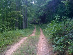
I got a pile of arrows, a stapler, staples and some pink ribbon and got ready to head up to the Bull/Jake area. At the last minute, I realized I didn't remember how part of the course was supposed to go. How could that happen? I designed the course, you'd think I'd know it. But, alas, I could not remember. I got online to look at it, but for some reason the route wouldn't pop up over the map. I'll have to look into that. We figured it out though and I got going.
My dad's got my truck at his shop right now, and I've got his Grand Marquis, so I had to keep my speed down and pick good lines on the gravel roads. It's funny, normally I don't think of those roads as being the least bit tricky, but they are in a 2wd car.
On the bike...
Puttin' up signs.

Hope this is enough to show people which way to go. On black branch, there were a bunch of orange ribbons already up for something else. At first glance they kind of look pink. Fortunately they go the right way though, so it's no problem if somebody gets confused. Hopefully nobody will follow them, realize they're not pink and backtrack looking for where they got mixed up.
At the end of Black Branch I stapled the signs up pointing the wrong way. Eddie just happened to be driving up right then and noticed the problem. Oh boy. I fixed them and headed down to 28A.
On the side of the road, a tree was knocked over. It looked like it had been pulled down by something. Maybe a bear? There was delicious looking red fruit all over this tree. I've seen pin and black cherry trees in various places up there, but this one had different leaves, with smooth edges, kind of like rhodo. Maybe it's laurel cherry? I'm curious because pin, black and choke cherry are good to eat, but laurel cherry is seriously toxic. I'll have to ask the experts.


I met Eddie at FS28A. He took of to mark Jones Creek. I headed up 28A...
... marked it to the No-Tell connector, and kept going up to Turner Creek, but first a little diversion...


I've been there before, but never got any pics until now.
Turner Creek is awesome. You come flying down Winding Stair, jog left, jog right and just keep on flying.

Woohoo! I put up ten billion signs at the complex intersection near the doubletrack, but first had to spend 10 minutes fixing the stapler. How can you misload a stapler? Well, I did, and almost got it all jammed up. Whee.
Marked the doubletrack.

Marked the singletrack across the creek. Headed back up 28A.
Marked the no-tell connector.

Climbed the gnarly climb at the top.

Turned down No-Tell...

...and, suddenly, torrential rain. Full wrath of nature rain. Stinging eyes from sweat getting washed into them rain. Ugh.
Before long I was back at the car. Eddie was still out there. Rain was still coming down. I took off my gloves and helmet, laid them on my trunk to wash out, sat down on a stack of rocks and enjoyed my outdoor shower. If it had been cold, it would have sucked, but given that it was in the mid 90's, the rain was actually nice.
Eventually the rain let up, but still no Eddie, and no cell service. Did he want me to meet him at Montgomery Creek? Man, I just couldn't remember. Something was wrong with my brain. I think I was about 20 IQ points short. I climbed up to the top of the hill and tried to call him. I had signal but he didn't. I went over to Montgomery Creek, but he wasn't there either, so I rode back and wandered around a bit.
Hey, look, chokeberries. (I think)

And some little vine fruit thing. What is this?

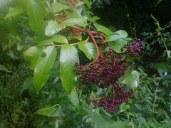
I'm pretty sure this is elder.
Eddie rolled up 5 minutes later, we drove to Wahsega, grabbed some more flags and marked the rest together. Eddie is fast. I'm sure he was just riding along, but I had to work hard to keep from being dropped on the climb back up to FS141. It felt like the Reality Wednesday ride. We got our mark on though, 141, Black Falls and the singletrack leading into the camp. There's this powerline cut that's tricky to mark and when we stopped there, we heard some large animal crushing it's way though the brush downhill from us. We didn't see it, but man, it was loud and raucous. Maybe a bear? I've only seen deer move gently through the brush, but I've seen bears manhandle it. Whatever it was, we could only see where it went, not what it was.
Ed's brother and nephews met us at Wahsega with pizza and drinks. Ed took me to get my car. I showered and changed. It was right at 9 PM when I got back on the road.
A long day, but a good day. The race is tomorrow. I actually need to get going now if I want to make check-in tonight.


No comments:
Post a Comment