Rain, rain. It rained all night and all morning. The weather map showed rain coming. I'd planned on riding with my dad, but I really didn't want to trash my bike today. My dad would be in town through at least Tuesday, so I should get another chance to ride with him. Plan B when it's wet is hiking.
Ages ago I drove my truck up FS880, AKA Two-Run Creek Road, but I turned around when I ran into a deep, rutted mud-puddle that I wasn't confident I could cross. Ever since, I've wanted to get back out there and see what's what, but I always had something better to do. Today I didn't.
But, first things, first. On the way to Two-Run, you pass through the Cane Creek Community. Recently I explored a bunch of trails leading from Horseshoe over to and up Cane Creek, but my map's still got a bunch of purple lines on it in the area south of there. Intent on killing two birds with one trip, I drove all around up in there first. Didn't find anything terribly interesting, but I did de-purple some lines, and that's always good.
On to Two-Run.
I parked just up the road in the first available spot and started walking. Before long I ran into the same mud puddle that had stopped me before. Today it was even more full and the deep ruts were totally obscured.
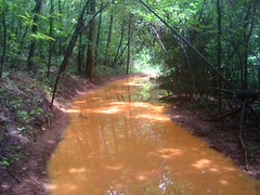
The frogs were having a great time though. I must have seen 5 or 6 big ones in this puddle alone. When they jump in and swim, they leave a trail of disturbed mud behind them, clearly marking their path. I wonder how well that works out when they're trying to escape from a real predator.
After looking at the ruts again, I'm not so sure I couldn't get my truck through them. But, even if I could, this would have stopped me.
But it won't stop me on foot. Onward. Upward.
I have an old map at home that shows the community of Two-Run on it, but it's not accurate enough to pinpoint the exact location. This road does lead up along Two-Run Creek. Maybe the community could have reached up in here. I looked hard, or at least as hard as one can look without leaving the road, but I didn't see any anything interesting.
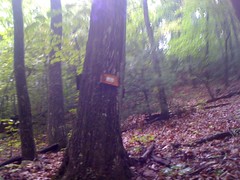
Well, maybe one interesting thing.
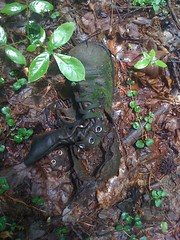
Looks like something's been gnawing on it.
I guess this is an orienteering marker. The rangers have much fancier markers. Maybe this one is for students at Hidden Lake. Who knows.
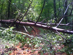
Before long I was past the northernmost point shown on my map, but the road kept going, and got much steeper.
Muuuuch steeper. Except for a few recently downed trees, the road was clear. It doesn't look like anyone's been brave enough to drive a Jeep up here in a long time though.
Maybe it would go all the way up to Long Mountain. Just as I wondered about that, it took a hard left and ended abruptly. Grrr. I checked out a couple of side trails below. Maybe one of them would lead over to Lumpkin Ridge.
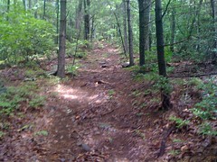
What do you know?! One did. At least, it almost did. It stopped about 20 yards short of the actual ridge, but the ridge was right there, so I just cut cross country, and lo, a trail.
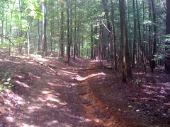
Ha! I'd always wondered if there was a trail on the ridge. Indeed there was, and a pretty clean one too. Would it lead up to Long Mountain? Only one way to find out.
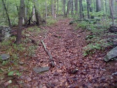
The trail was steep and braided. It split, weaved and rejoined itself a dozen times. Did I mention that it was steep. Yeah, and it was also steep too. But it did, in fact, lead right up to Long Mountain, and right where I'd thought that it might. I'm not sure how it was that I didn't see it last time I was up there.
It teed into a clean trail running east-west along the Long Mountain Ridge. I wanted to head east and see where it went, but my brother had invited us over for dinner and my dad had just called to remind me. I had about an hour to get back to the car. Long Mountain would have to wait.
Down.
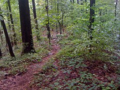
Down, down, down. The trail just followed the ridge. I was making good time, even jogging when I could.
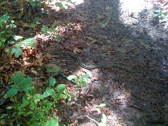
The slithery type. I saw one of these last time I was hiking too. Circle head, no danger.
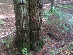
This stuff is a bit dangerous though, if you don't see it and almost walk right into it like I did.
Eventually I got down around Hidden Lake and had to stay to the left to stay in the national forest, but it was well marked.
I could tell I was getting close to my truck because I could hear and even see some guys in a red Jeep gitten-er-done down below on 880. Not far past Hidden Lake, the trail just kind of petered out. The woods was nice and open, but there was definitely no trail. I followed the ridge until it got dense, then just gave up, backtracked and walked downhill to 880.
I didn't find any waterfalls or old houses, but I did find some nice new trails, and of-course, a snake. All-in-all, a good day.


No comments:
Post a Comment