A few weekends ago, I tried to ride at Fightingtown Creek, only to be pushed back by the weather. The next weekend, I was determined to actually ride there. The urge to hit a bunch of different trails in one day had pretty much passed by that point. I just wanted to hit this one.
I had a sense of where it was, but I didn't know for sure. Back when I was exploring the Cashes Valley area, I saw Fightingtown Creek on the map, so I knew it was in that general area. It's funny... In that general area, there are: Fightingtown Creek, Devil's Den, Hell's Hollow, and Dyer Gap. Such intimidating names! I used to know a guy who married a lady with the last name of Payne, who was from halfway between Devil's Den and Hell's Hollow. His family used to joke with him about that.
Siri knew where it was though, and got me there in good time.
It's really out in the middle of nowhere, as all good trails are, way back up a nondescript road, with a bunch of random houses on it. It kind-of looks like a neighborhood. Not exactly somewhere you'd expect a trail system to be. Yet there it is.

The system consisted of 4 trails: Upper and Lower Prince Loops, Laurel Loop, and the Creek Loop.
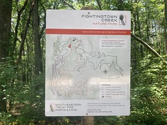
The Prince Loops are named such because the whole system lies on Prince Mountain. The Creek Loop runs along Fightingtown Creek proper. I'm not sure where the Laurel Loop gets its name from.
There were a number of cars in the lot when I got there, both hikers and mountain bikers. it seemed like a popular place. I got dressed, hit the trail, and had a blast, right away.
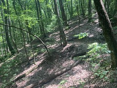
The whole system is fast, twisty, bench cut. More of that Sorba trail I've recently described, but modern sorba trail, with more aggressive grades, switchbacks, and rocks. You can fly, but at those speeds, it's pretty technical.

I ran into a hiker coming the other direction about halfway around Lower Prince, and we chatted for a second. I wanted to ride everything out there, and since Lower and Upper Prince were stacked, I ended up riding Lower Prince again, and passing the same hiker the second time. At Upper Prince, I realized that I hadn't started Strava, and so I ended up riding yet a third lap around Lower Prince to get the GPS data, after riding upper, once again, passing the same hiker.
After the Princes, I rode the Laurel Loop, which was basically just more of the same, if not slightly more aggressive.
The whole system had that just-built feel to it. It was pretty well worn in, but the backslope was still very notched in, and the outside edge hadn't rounded off yet. It looked like P3 when it was first cut. I'm sure in a few years it'll look like P3 does now.
About halfway around Laurel, I passed an elderly gentleman on an eBike, and then a little while later encountered a guy coming the other way. The trails are directional, so we spent a few minutes figuring out which of us was going the wrong way. I was relieved to find out that it wasn't me, but it just as easily could have been.
There were a couple of humps on Laurel that I was tempted to boost, but was then glad that I was conservative with it because in almost every case, the trail turned abrubptly afterwards, and it could have been ugly if I was still in the air.
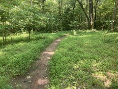
The Creek Loop seemed more difficult than the other three. At first I thought maybe I was just getting tired, but after riding it a bit, no I think it was actually more difficult. Rockier and twistier, I think. It looked like some of it might have been road-trail-conversion and other bits just followed an old trail that was good enough. There were a bunch of switchbacks that appeared to have taken the place of an older, fall line trail. Some of it was just in the flats and kind-of soft as a result.
Down at the bottom end of the trail, there was an old chimney.
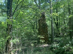
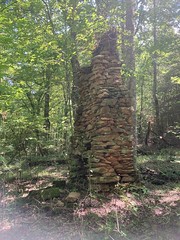
There were also ruins of this strange creek camp.

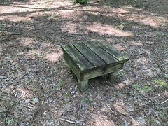

No idea. I'm curious about the history of the area now, though.
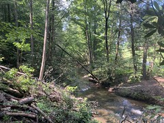
Eventually the trail dropped down and ran along the creek itself for a few hundred yards through a magnolia tunne. The magnolia was blooming at the time, and it was really pretty. There was also this section where trees had fallen, where you could get a good view of the creek.
The climb back up to the parking lot involved those switchbacks that I mentioned earlier, and it was a bit of work.
When I got there though, I noticed that the lady that I'd seen hiking earlier, and the guy on the eBike were hanging out in some chairs, talking to each other. It turned out that they were a couple, and both in their late 70's. He likes to ride and she likes to hike, so they go do that together. It made me really happy talking to them, and we talked for a while.
As I was changing back into my regular clothes, I noticed some hemlock buds nearby.

I didn't realize they'd still be budding this late into the summer, but it was nice to see. They're pretty tasty, like something between orange juice and Pine Sol. I guess not so much delicious as novel, but still, a treat.
On the way in, I'd passed a church, and on the way out, I noticed its strange, hanging tables.


Pretty much every church in North Georgia has an open-air pavilion with tables under it. They're usually concrete though. Occasionally you'll see a wooden table. I'd never seen one that hangs from the roof of the pavilion though. Very interesting.
I don't remember now, but I had some reason to get back home, so I didn't dally about. I think I ate at Shane's in Ellijay, but I really don't remember that either.
So, Fightingtown is a well designed and well built trail system. It's definitely more of an enjoy-the-trail type system, than an enjoy-the-woods type system, but there actually is a good bit of enjoy-the-woods and enjoy-the-weird-stuff-in-the-woods on the Creek Trail, so some of both, really. It'd be great if there was some way to get to it from the Bushy Head Gap area, which is just over Prince Mountain to the west. There are a bunch of nice gravel roads over that way, and it would be cool to be able to combine them all into a longer ride.
Maybe some day.


No comments:
Post a Comment