In late June, I had an annual work thing down in Sarasota, and like last year, instead of flying down, I drove, and I brought my bike with me so I could ride somewhere on the way back to Atlanta. I hoped to ride somewhere in the immediate Sarasota area, but it looked like the local trail was actually a bit south and I didn't want to have an even longer drive home, so I started looking at what was on the way back. There was some trail that looked great, but various comments indicated that it was no good in the summer - always underwater. So, I kept looking, and eventually found the Wilderness Park Trails, AKA Flatwoods.
Looked like I had a plan.
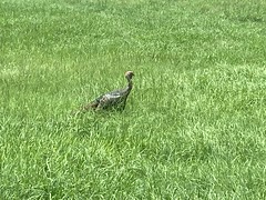
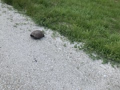
It was a little tricky to find the trailhead. Mile 0 was kind of up on a levee, and there wasn't any parking nearby. The only thing in the area was this turkey.
It turned out that the actual trailhead was in a big lot, out on the main road. It was really pretty obvious. Only I would have trouble finding it.

I got changed, paid the parking fee, and studied the trail map for a bit.
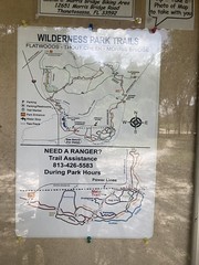
It looked like I ought to spin a loop around the Flatwoods Loop, picking up some of the farther-out side loops when I got to them, then try to decipher the various southern loops when I got back, if I still had energy to do it.
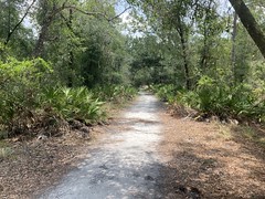
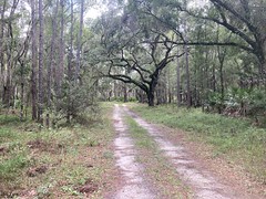
The Main Trail was pretty well traveled and fairly easy to follow. The woods was mainly pine and oak, with a million palmettos, and the occasional cactus.

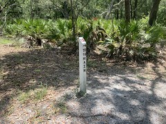
There were trail markers at nearly every intersection.
The character of the trail changed pretty regularly too. Eg. it popped out on a right of way for a while...

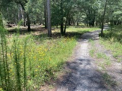
...then went back into some fairly open woods with wildflowers...
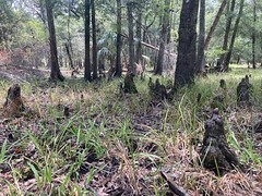
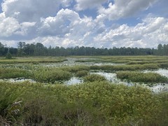
...and there were wetlands replete with cypress knees...
...and a little pavement...

...which included a crossing of the Hillsborough River.

The first option I had was the Eubanks Parkway. Rather than take it immediately though, I followed the main trail up and around, then looped back on it. Oddly, there was also an Int 2 trail at the first intersection, which was not on the map.

Interstate 2?
Eubanks looked like it got substantially less traffic than the Main Trail, but it was still pretty fun.
I eventually realized that Int 2 meant Interpretive Trail #2. There were all kinds of interpretive signs along it, and some benches. It looked like it got a lot of traffic. Way more than Eubanks. It seemed like it ought to be a loop, but instead, it circled around and eventually teed in to the Main Trail. To get back to the start, I had to get out on the road for a while. That would have been weird if I'd been on foot. I could kind-of see where the loop might have once continued, but it was pretty overgrown when I rode it.
IDK. Weird.
So, the main trail teed into a road, which I had taken left, then looped back on Eubanks and Int 2. I eventually ended up back at the road where those 2 trails split off, and there was a kiosk with a map and a you-are-here there. While studying the map, a roadie rode up and we talked for a bit. He knew which way to go, and was headed that way, so I followed him on the road until I saw the trail.
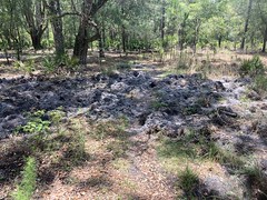
Along that section of the trail, and really, along the entire rest of the trail, there was a good bit of hog rooting.
I eventually started seeing pigs too. At first, just little black foot-long dudes, but eventually gigantic 200+ pounders. One was tan with big black cow spots all over it. That one took off running parallel to the trail and it seemed like every time it would turn, the trail would turn too, and I accidentally chased it for like a quarter mile before it finally crossed the trail and took off to my left.
At the far north end, there were more wetlands.

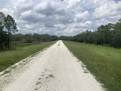
The trail up there zigzagged back and forth across this doubletrack...
...occasionally popping out and running down along it.
It was definitely more of an "enjoy the woods" kind of trail system than an "enjoy the trail" kind of trail system. While the trail was fun to ride, the woods itself was also just so beautiful. At least to me. The live oak, longleaf pine, spanish moss, cypress, and all those palmettos... you just don't see any of that in North Georgia. Well, maybe the occasional live oak, but they're usually pretty stunted. I'm sure if I rode there all the time it wouldn't seem like much, but seeing it so rarely, it made quite an impression.
The Panther Trail teed off to the north, so I took that loop. There were even more beautiful wetlands off of the Panther Trail.
There was also a road up there that forded some other feeder of the Hillsborough, and some side trails. I think one was called Squiggy. I rode all of that before ending up on a Levee...
...and taking that back north to eventually loop back to the Panther Trail.
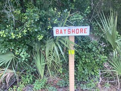
The Main Trail eventually led back around to that same levee, further south, and just ran along it for a while. At that point, I was pretty close to where I started. Mile 0 was up on that levee. There was an almost separate set of trails down there, the Bayshore Trails, and I milled around on them for a while. They basically looped around a couple of lakes, in different directions. One of the trails was super rooty and bumpy, and I somehow ended up riding it twice. Not on purpose.
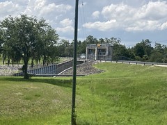
At at point, I realized that I'd explored most of the official trail, other than the maze on the south side of the main road, so I rode back and forth, and around the bottom end of the levee for a bit, and got a shot of the dam.
I also encountered three separate Gopher Tortoises!


Ok. Time to explore this maze of trails on the south side.
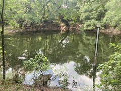
First up: Sinkhole.
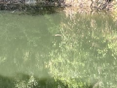
I could totally see why it was named Sinkhole. It passed by not only one, but two sinkholes.

The second of which had a pretty big snapping turtle floating out in the middle of it.
From Sinkhole, I tried to ride Grandpa, but ended up somewhere else, and had to figure out how to get back to where I meant to be. Somewhere in there I crossed paths with this beautiful yellow rat snake.
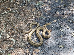
I rode around the end of a tree that had partially blocked the trail, and it was stretched out on the other side. I had to speed-hop to keep from running over it. Fortunately it didn't flee, just contracted, and I was able to get a photo. The only yellow rat snakes I've ever seen have been in Florida. One on the CFiTT, way back, and this one. I don't think they exist in North Georgia, or if they do, they're super rare.
It wasn't long before I gave up trying to decipher the trails on the south side there. While the intersections were well marked, I couldn't always reconcile what I was seeing on the ground with the map. I was also running low on water and food, and honestly, the heat was getting to me. I also had a long drive back still ahead of me, and I didn't want to be crawling in at 2 in the morning, so I packed it in pretty quickly after seeing that snake.
Man! So much wildlife - turkeys, pigs, turtles, and a snake! It would have been a great ride just for all the wildlife.
I was a little sad that I didn't persevere and ride everything, but hey, If I'm back down there next year again, I'll see if I can pick up the rest of the system.


No comments:
Post a Comment