After ripping Chicopee the day before, I was a little tired this past Sunday. I still wanted to ride, but I felt like exploring something new, rather than hammering or grinding. My initial plan was to ride at Cohutta Springs, which is way up near Sumac Creek, almost in Tennessee. I hit the road a little late, but hey, it's summer time, and the sun doesn't set until about 9, so it really didn't matter.
75 to 411, and 411 up through White, Rydal, Ranger, Chattsworth, Eton, and a bunch of other little towns. I had forgotten just how many of them there are. Back in the early 2000's, we used to drive up that way a lot, to get to Fort Mountain, Sumac Creek, Iron Mountain, and even Windy Gap. But, that was pre-Pinhoti, and pre Mulberry Gap. I wonder how much traffic those trails get these days...
But I digress. As I approached the Cohutta Springs property, I noticed signs saying things like "Private Road, Registered Guests Only" and such. Was this place private? That would be a drag. I hadn't read anything about that in any of the resources online. That would also be just my luck. I ended up calling them, and yeah, it's a private facility. It is possible to get a day pass to ride the trails, but not until fall, because there are kids at camp there all summer.
Well, crap. What else can I ride? I wracked my brain for a minute, remembered that there are various roads off of FS630 (Mill Creek Road), including Rocky Flats. The last time I rode that was with my Dad, in like 2001, and I didn't even own a GPS at the time. Yeah, I could explore Rocky Flats. That might be fun. I needed batteries though. The batteries in my GPS were questionable, and I'd need to mark waypoints. I couldn't just rely on the strava app today.
I'd seen a Dollar General on the way in. In fact, I'd seen one in every town along 411, all the way up. There must have been a dozen of them. But, again, I digress. I headed back to the DG, which was like less than a mile away, purchased some batteries, and headed over to Rocky Flats.
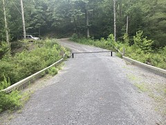
It took me a minute to figure out where to park. I couldn't tell if I was at the bottom end of it, or the top end, and I didn't recognize it from 20+ years ago. After driving around for far too long, I figured out where I was, parked, got dressed, and got going.

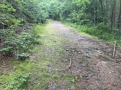
Rocky Flats is, in theory, an OHV trail, but it's super well maintained, and almost entirely on par with an average FS road, if slightly less well-used.

Way out near the end, there are some ruts and puddles, though.

So, it's like the Dallas trail of forest roads - generally easy, but punctuated with challenges.
Or, at least that's how it would be in a Jeep or something. I was on the bike and it was nothing.
There were a bunch of side trails that, oddly enough, I still remembered seeing years ago. One went to a food plot, and I didn't find anything continuing on from there.
One had the character of a firebreak, but it didn't go super far up the mountain, and it looped back on itself, weirdly. Maybe just a strip cut? I don't know, it was odd.
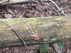
There were cool claw marks on a piece of deadfall on that one.

I also got stung twice, on the butt, by a yellow jaket, while exploring that. Man, it hurt. I joked with a friend later that I needed to hire a personal injury lawyer to sue the yellow jackets for pain and suffering.
There was another trail that also had the character of a firebreak. It was pretty well choked with deadfall though. On foot, it wasn't a big deal at all, but it wouldn't have been possible to ride it, for very far, at least, in either direction.
There was one scenic feeder creek, but it was hard to get a good photo of it.

Other side trails included active and abandoned camp sites, a steep climb, and a tricky climb that then paralleled the road and came back down.
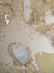
Out at the end, there were both turkey and bear prints in the sand and puddles.


It's their woods, really. We're just visiting.
If I remember correctly, Alex Nutt's book said, ot at the end there, to hang a hard right, up over Kelley Humps, and follow the trail back toward FS630. Before it hits the road, it drops down steeply to the creek, crosses it, then ascends steeply up to the road. Something like that.
Oddly enough, the directions for where to park were also something like the reverse of that: hang a right, cross the creek, ascend the other side, and park. I want to say that the mileage was off too, or I misunderstood it. At any rate, when we first drove out there, I mistook the lower end of the trail for the upper end, and drove my Durango, with bikes on the roof, down and across the creek, and began trying to climb the steep-ass jeep trail on the other side. I quickly realized that I did not have the skills to do that, bailed on the attempt, backed down into the creek, and wasn't sure what to do next. Fortunately some guys that knew what they were doing just happened to be driving by, saw us, came down, and talked me through how to get out of the creek and back up to the road. In later years, I developed much better 4wd skills. The descent down to the creek, and back up to the road would have been nothing to future Dave. The steep climb up the other side, however, I never got good enough that I'd have felt confident attempting, and it was fortunate that I'd had the presence of mind to bail on it when I had.
At any rate, way back, when my Dad and I first rode there, the road didn't exactly end where it does now. There were humps, but you could definitely drive a Jeep farther down it, so we kept going, thinking we were still on the right path. Not having a GPS, or even bike computer, we didn't realize where we were, or that we were supposed to have taken that hard right. Eventually, we hit a second set of humps, with a super old, faded, almost unreadable Private Property sign lying on the ground on the other side that looked like it had been there for 50 years. At the time, it struck us as abandoned, and not being necessary to pay attention to. That was actually, kind-of true too. We popped out into some old, abandoned-looking property - there were some old homestead-type buildings to the left, a grassy patch between some overgrown corn fields, and eventually an abandoned-looking, but modern house. We could see the Ellijay-Crandall road ahead of us, and there were some drunk guys on 4-wheelers parked up by the road, who had, it seemed, been riding back in there just like we had. Since those days, the entire farm has been renovated, and the property probably wouldn't be as safe to cross as it was.
But, again... I digress. The other day, I made it out to the end of the road, and where my Dad and I had continued the last time was now, thoroughly overgrown, and looked impassible. Maybe in winter, on foot, but definitely not by me, that day. I checked the hard right, and it too was impassibly overgrown. There was a side trail, just a little ways back, that looked like it might have bypassed the humps, so I checked it out, but also became overgrown pretty quickly. Again, maybe on foot, in winter, it would be different, but I couldn't have ridden it that day.
Eventually, I turned around and just backtracked out. When I got back near my truck, there was a couple with 2 little kids milling around by the creek. I talked to them for a while. They'd been caving the day before, and needed to wash their clothes. Rather than wreck their washing machine, or clog their bathtub, they'd taken them to the creek to hand wash. They'd throw them in the washing machine when they got home, but this was the first pass.
On the drive out, I couldn't find any trace of the road that I'd taken down to the creek 20 years ago. I'm sure some remnant of it still exists, but I couldn't remember where to look. Maybe if I go back up and look carefully, I'll be able to find it.
So, I more or less salvaged the trip up there, and had a good time exploring the mountains, which I haven't done much of in a really long time. It felt good. Maybe I'll do some more of that in the coming weeks.


No comments:
Post a Comment